
Caitlin Dempsey
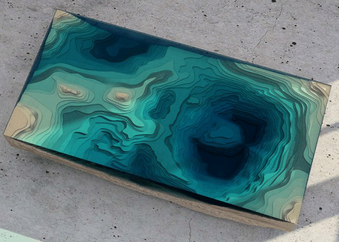
Topographical Tables – Geography as Art
These furniture designs combine glass, wood, and other materials to emulate the land and water. Ocean Table Christopher Duff of ...

Explore Maps of the United States from 1884 to 2006
The U.S. Geological Survey and Esri are working together to make over 178,000 maps of the United States available to the public via an ...

What is a Pole of Inaccessibility?
A pole of inaccessibility is a geographical point that represents the most remote place to reach in a given area, often based on distance from the nearest coastline.

Where Can You Travel On Your Passport?
How easily you can travel across the world is determined on your passport's listed nationality.

GIS Data of the World’s Wetlands
There are currently 2,185 sites worldwide that the Ramsar Convention considers to be wetlands of international importance representing over 208,597,750 hectares. GIS Data for Ramsar sites is available from Wetlands International.

Rud-e-Gaz and Rud-e-Hara Wetlands, Iran
This satellite image captured of southern Iran shows what an arid and inhospitable area most of this region is.
Gender in the GIS Workforce
This article takes a look at the state of gender balance in the GIS industry.

The Great Inversion – Cities That Are Outpacing Their Suburbs
The rise of the suburbs and the declining urban city which dominated much of American growth in the last half of the Twentieth century is reversing course.

How the Earth’s Magnetic Field is Changing
The ESA recently released the results of data collection from Swarm from the past six months that analyzed changes in the Earth's magnetic field.

Using Google Street View to Track Urban Decay
The Michigan city of Detroit has an estimated 20 square miles of vacant, abandoned and underused land.

Statistics for Thematic Cartography
The Geographic Information Technology Training Alliance (GITTA) has an online lesson plan that provides some helpful information about creating thematic maps. ...

Tule Fog Declining in California’s Central Valley
A group of researchers analyzed satellite imagery over a 33 year span to establish an understanding of the fog climatology in the Central Valley.

Access CryoSat-2 Ice and Ocean Data Products
CryoSat-2 has been collecting data since its launch in 2010, allowing scientists to better understand changes in the thickness of polar sea ice, the elevation of the ice sheets that blanket Greenland and Antarctica, and mountain glaciers.

Tonle Sap Lake – One of the World’s Most Productive Freshwater Ecosystems
Located in Central Cambodia, Tonle Sap Lake is the largest lake in Cambodia and is considered one of the world's most productive freshwater ecosystems.

Where is the Only Area in Europe Where no Borders Exist?
Lake Constance's shoreline touches three different countries: Germany to the north, Switzerland to the south and Austria at its eastern end. The water body itself contains no borders since there is no legally binding agreement between the three countries.

Mapping Time: A Detailed Look at Minard’s Flow Map
Mapping Time: Illustrated by Minard’s Map of Napoleon’s Russian Campaign of 1812 combines historical and geographic analysis with cartography to examine mapping change over time.

Aralkum Desert: The World’s Newest Desert
Replacing the shrinking areas of the Aral Sea, the Aralkum Desert is located in Uzbekistan and Kazakhstan, making it the world's youngest desert.

Verifying Ancient Roman History with GIS
Tom Whitley, an Assistant Professor of Archaeology at the University of Western Australia (UWA), used GIS to test population estimates and patterns of migration and war to see how the historical aspects known about the Gallic Wars measures up to geophysical evidence.

Meet a Geographer: Kristina Jacob
Kristina Jacob, a GIS professional, shares her thought about what drew her to both geography and photography.

National Climate Assessment Report Released
The National Climate Assessment, an important report on the impacts on climate change in the United States today and in ...

GIS Data of the World’s Glaciers
An international group of seventy scientists hailing from more than eighteen countries have created the first global datasets of the ...

Richat Structure: A Geologic Wonder
The Richat Structure, a geologic wonder viewable from space, is a striking circular feature found in the Sahara Desert in ...

When Streets Have No Trees
The presence of trees in cities yields multiple benefits.

Teaching Basic Map Skills To Young Children
These books and online resources help teach young children spatial skills and map making.

Five Fun Facts About International Borders
Learn about some of the most fascinating international borders in the world.

Tobler’s First Law of Geography
The first law of geography was developed by Waldo Tobler in 1970 and it makes the observation that 'everything is usually related to all else but those which are near to each other are more related when compared to those that are further away’.