
Geo Contributor

How Collecting LiDAR is Being Supported by the USGS 3D Elevation Program
Quantum Spatial (QSI) is currently working on more than two dozen LiDAR collection projects in support of the 3DEP. Here’s a look at three of the projects QSI has worked on in 2018.

How Texas is Using Geospatial Technologies to Mitigate Forest Fires
Texas A&M Forest Service partnered with Timmons Group, a national geospatial solutions firm, to develop the Texas Wildfire Risk Assessment Portal (TxWRAP).
How Plex.Earth is Used in Teaching: An Interview With Professor Martin Cajade
Eleni Natsi of Plexscape interviewed Martin Cajade, a FADU faculty member at the University of the Republic in Uruguay, on his students' use of PlexEarth as a data mining tool.

What Imagery Source is Best for Your Business?
Erin Jepperson, Technical Sales Engineer at Nearmap, outlines how to weigh the pros and cons of aerial imagery and drone imagery.

A Story Map Journalism Experience
Eudel Cepero shares his experience developing a popular story map for Diario de Cuba using ArcGIS Online.

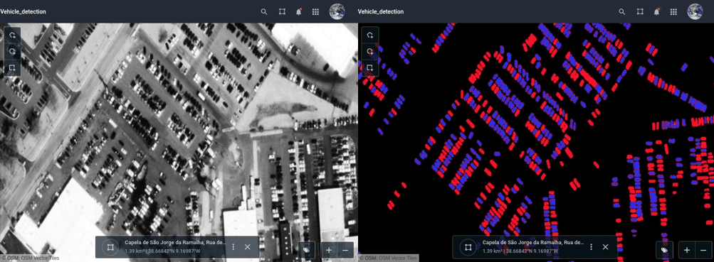
Seeing the World with Data: 3D LiDAR with MapD and Uber’s deck.gl
Dipti Kothari, an intern with MapD, has developed an open source project that uses LiDAR to create a 3D visualization of tree coverage around buildings and the impact of rising sea levels on buildings on Jekyll Island, GA.
Run Image Processing Tasks in Your Browser with the EOS Platform
This guest article by EOS introduces the newly upgraded EOS platform, a set of mutually integrated cloud products for searching, analyzing, storing, and visualizing geospatial data: Landviewer, Processing, Vision, Storage.

Regulations Affecting the Use of Drones in India
Bankim Chandra Yadav, a Ph.D. student at Indian institute of Technology Roorkee, discusses unmanned aerial vehicles (UAVs) technological implications under the Indian government laws.

The Rise of African Mapping Technologies
Stuart E. Hamilton, GIS Graduate Director at Salisbury University in Maryland, discusses why he considers East Africa to be a leader in geospatial education and opportunities.

Adding “Early Voting Wait Time” Information to a Layer in ArcGIS.com
Tracy Garrison outlines an example of how a “County” might provide current early voting wait times to the public with ArcGIS.com and coding.

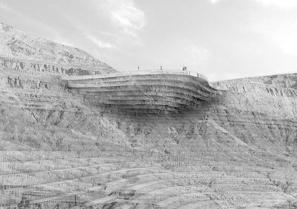
When Predictions Match Reality: The Power of LiDAR for Flood Warnings
LiDAR data is being used to develop highly accurate elevation-enabled flood inundation mapping in advance of major storms in North Carolina.

Is the Newly Revised Geospatial Data Act Worth Supporting?
Anthony Calamito, Chief Geospatial Officer of Boundless, explains why Boundless stands behind the new Geospatial Data Act.

How LiDAR is Being Used to Help With Natural Disaster Mapping and Management
Michael Shillenn, vice president and program manager with Quantum Spatial outlines three projects where LiDAR data from the USGS 3D Elevation Program (3DEP) has been used to assist in planning, disaster response and recovery, and emergency preparedness.

OpenRouteService’s ‘Quiet Routing’ Creates a Less Stressful Route for Pedestrians
Prof. Dr. Alexander Zipf introduces OpenRouteService's experimental routing option 'Quiet Routing' which guides pedestrian travel around noisy urban areas.

How to Make a Map in Excel Using the 3D Map Add-in
This tutorial by Nick Williams provides an overview of how to create a map in Excel using 3D Map for Excel 2016 (or Power Map for Excel 2013).

Using Free and Open Source GIS to Support Natural Resource Management in the Developing World
Rohan Fisher describes his GIS work for decentralized, evidence-based resource management in developing nations.

WMS Map Viewer
WMS Map Viewer, developed by Pantelis Rodis, is a http/JavaScript application for visualizing, combining and indexing web maps.

Creating and Editing Features with MapInfo
This tutorial by Nick Williams, a MapInfo trainer at Acuity Training, provides an overview of how to create, edit, and convert features within MapInfo.

GIS RoadMap and Mobile Strategy for Engaging Missouri Constituents
Douglas Fees, the Information Technology Services Chief with the Missouri Department of Conservation (MDC) discusses how his agency collaborated with Timmons Group to develop a GIS roadmap and mobile strategy that resulted in a suite of applications to better serve citizens, visitors and internal MDC staff.

Using GIS to Conserve the Greater Sage-Grouse
GIS has emerged as an essential analysis and communication tool for the Oregon BLM in general, and its sage-grouse conservation efforts.

Understanding What Six GIS/Map Software Providers Offer
Matt Sheehan from WebMapSolutions is posing a series of six questions to six GIS/map software companies (Pitney Bowes, Esri, Mapbox, Carto, GIS Cloud, and Boundless) to understand their similarities and differences in product offerings.

Using Terra and Aqua Layers with Open Satellite Map
Georgy Potapov of OpenWeatherMap introduces the availability of low resolution MODIS imagery from Aqua and Terra satellites via the VANE platform.

Habitat Fragmentation: A Multi-Scale Approach detailing its lasting impact on Earth’s ecosystems
An analysis performed at multiple spatial and temporal scales argues that destruction and degradation of natural ecosystems are the primary cause of global declines in biodiversity.

Three Examples of Geospatial Innovation in Emergencies
Bailey Morton outlines three examples of how innovative geospatial analysis can help save lives in emergency situations.

VANE Query Language: Intuitive Access to Satellite Imagery
Georgy Potapov of OpenWeatherMap introduces the release of the VANE language service, an entirely online service that presents a new concept for accessing satellite imagery. Potapov shares OpenWeatherMap’s vision of how developers can work with satellite and weather data to help the overall geoinformation market to grow.
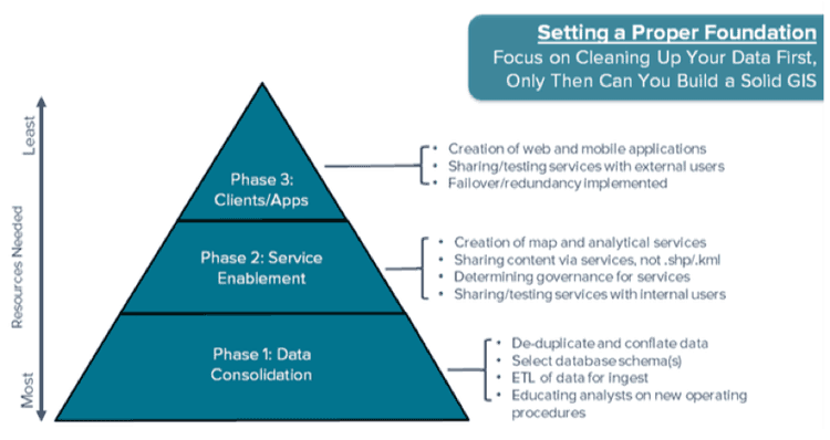
Harness the Power of Open Source GIS with a Hybrid Architecture
Anthony Calamito, Chief Evangelist at open source GIS company, Boundless, explores how companies can harness the power of their open source GIS systems.