
Geo Contributor

Next-generation Lidar: Seeing the Forest Through the Trees
Next-generation Geiger-mode lidar’s high density and multi-angle looks offer a better chance of seeing through tree foliage to map what's underneath.

6 Open Source Powered Projects to Enrich Your GIS Programming Skills
This article presents six projects with suggested tools, prerequisites and learning resources that would help you to improve your geospatial programming skills.

Mapping Our World, Saving Lives with Humanitarian OpenStreetMap Team
The “Mapping our World: Saving Lives” episode of the AfricaGeoConvo Podcast, examines the world of mapping and volunteering, with Geoffrey Kateregga.
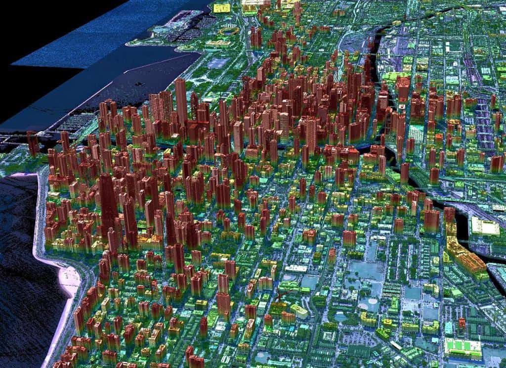
Geiger-mode Lidar and Geospatial Data Acquisition
Paul Nash discuses Geiger-mode lidar and its use in geospatial data acquisition.

3 Tips to Help You Get a GIS Promotion
This article from Bootcamp GIS provides tips for how to get promoted in GIS.

5 Reasons why the GIS industry continues to grow
If you work in GIS, you have seen tremendous growth in software sales, services, and solutions over the past 20 years.

3 Tips to Maximize the Value of Your GIS Internship
Andres Abeyta, the Executive Director of Bootcamp GIS, discusses three ways to get the most of your GIS internship.

Securing a Funded GIS Graduate Program
Adebowale Daniel and Nnenna Nkata from the AfricaGeoconvo podcast share important information about securing a GIS graduate program.
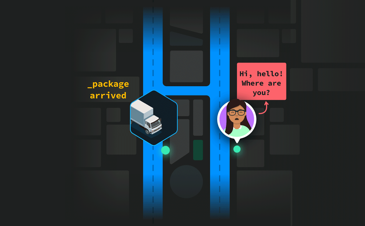
Last-Mile Problem: Achieve Pinpoint Accuracy With Hyperlocal Maps
Curated points-of-interest of a hyperlocal mapping and routing solution enable enterprises to lower cancellations and achieve higher map accuracy.

How Much Would the Ocean Rise if Everyone Sat in it?
If everyone in the world decided to sit in the ocean all at once, how much would the sea level rise?

Using ArcGIS Online to Manage Content
With the Item Report Dashboard from GEOACE, you can use out-of-the-box tools in ArcGIS Online to manage content within an organization.

Billions of Cicadas Will Be Emerging In the United States
Starting sometime in April or May, depending on latitude, one of the largest broods of 17-year cicadas will emerge from underground in a dozen states.

Using GIS to Create a Vaccination Route Modeling Tool
NHS South, Central and West CSU has developed the new bespoke Covid-19 vaccination route modeling tool using Esri's GIS.

From the Arctic to Mexico: Tracking the Epic Migration of Birds
In winter, more than 1 million shorebirds that breed in the Arctic will visit and move throughout the coastline of northwest Mexico.

Eco-fusion: the Mixing of Native and Non-Native Species
Species have moved (and have been moved) around the planet recombining to establish new or “novel” mixes of native and non-native species.

Why the ‘One Map Fits All’ Approach Doesn’t Fit All
A custom map stack can help leverage maps in new exciting ways.

Mapflow.ai — New Buildings Model and Kepler.gl Implementation
GeoAlert provides an overview of some of the features of its new Mapflow application.

How Black Cartographers Highlighted Injustice
The work of the Black Panther Party, a 1960s- and 1970s-era Black political group featured in a new movie and a documentary, helps illustrate how cartography can illuminate injustice.

New GIS Dataset on the Interconnection Between Urban Centers and Rural Areas
A freely downloadable GIS dataset – the Urban–Rural Catchment Areas (URCAs) – shows the diversity of urban-rural systems worldwide.

NextBillion AI Solves HyperLocal Geospatial Infrastructures To Advance Mapping Ecosystems
NextBillion AI builds AI-based geospatial infrastructures to strengthen logistics, transportation, and supply chain services throughout the ecosystem.

Using GIS to Map Election Results Based on Where People Live
Greg Bunce, from the State of Utah’s Automated Geographic Reference Center, presents an approach that uses GIS to create more representative election results maps.

Automatic and Efficient Data Logging of Weed Management Activities
Harley Schinagl, the developer of STA logger, write about how this geospatial hardware is designed for conservation and land management fields.

A View of 2020 from Space
EOS Data Analytics, an AI-powered satellite analytics platform, shares satellite imagery that highlights some of the environmental tragedies that occurred in 2020 — California and Colorado fires, Hurricane Laura, Kamchatka spill, Norilsk oil spill, and the Calving on the Brunt Ice Shelf.
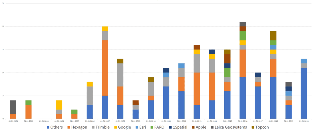
Mergers and Acquisitions in the Geospatial Market (2001-2020)
Andrey Pirogov, founder of GISGeo Project, takes a look at mergers and acquisitions in the geospatial technology market from 2001 to September 2020.

New “Map Projections for Babies” Board Book Helps Encourage Early Communication and Learning
Dan Ford explains how support from the geospatial community will help bring the "Map Projections for Babies" board book to life.

GIS: Thinking Beyond the Map
Now more than ever, GIS data is being used among a diverse set of industries and users.