
Physical Geography
Physical geography focuses on geography as an Earth science (and is sometimes called Earth System Science).
Physical geography is a branch of geography that focuses on the study of the natural features and processes of the Earth’s surface. It includes the examination of landforms, climate, vegetation, soils, and water resources. Physical geographers use a range of scientific methods and tools to analyze and understand the complex interactions between the Earth’s physical systems.
Learn about the different branches of geography that fall under the physical geography category: climatology, geomorphology, biogeography, and more.

More Animals Are Becoming Nocturnal Thanks to Human Activity
Researchers from UC Berkeley undertook a study that looks at the effect of human activity on the daily activity patterns of wildlife.

Lava from Hawaii’s Kilauea Volcano Reaches the Ocean
This image captured by the USGS-HVO shows the active ocean entry of a branch of lava from the Kīlauea Volcano in Hawaii.

The Aorounga Crater in Northern Chad
The Aorounga Crater is an impact crater located in northern Chad just south of the Tibesti Mountains in the central Sahara desert.
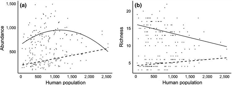
Study Finds a Lower Abundance of Songbirds in Poorer Urban Areas in England
A recently published study looked at the spatial relationship between people and birds across urban areas in Southern England in order to understand patterns of abundance and species richness among birds in populated areas.

King Penguins Like to Maintain Just the Right Amount of Personal Space
Researchers found a liquid-like spacing in King penguin colonies is the result of a balance between territorial pecking and a need to form in large groups as protection against predators.

Marine Heatwaves are Becoming Longer and More Frequent
Researchers, using satellite observations, have found that marine heatwaves are becoming more frequent and longer lasting.
An Eye Protein May Be What Allows Birds to Sense Magnetic North
New research proposes that Cry4, a light-sensitive protein found in the eye's retina may be responsible for magnetoreception in birds.

NASA Wants You to Send Your Name to the Sun
To celebrate an upcoming groundbreaking mission to the Sun's atmosphere, NASA is inviting the public to submit their names to be added to a microchip which will be placed onboard the Parker Solar Probe.

The Great Pacific Garbage Patch is Much Larger Than Previously Thought
Researchers using surface trawl samples and aerial imagery surveys have calculated the amount of plastic debris in the Great Pacific Garbage Patch.

Debris from the 2011 Japanese Tsunami Carried Almost 300 Marine Species Across the Pacific Ocean
A group of researchers inventoried what marine species traveled across the Pacific Ocean between 2012 and 2017 as the result of a biological rafting event created by the 2011 Japanese Tsunami.

How Often Does it Snow in the Sahara Desert?
The sight of snow in the Sahara Desert is rare, but it does happen on occasion.

Nighttime Illumination Continues to Grow Worldwide
A new study used remotely sensed data from an earth observation satellite to analyze the rate of increase in artificial night lights between 2012 and 2016.

Map of Cold and Hot Temperature Anomalies Across the World
NASA has compiled a temperature anomaly map of the world using data acquired between December 26, 2017 and January 2, 2018.

Hurricanes, Sea Salt, Dust, and Smoke
This visualization from the Global Modeling and Assimilation Office (GMAO) at NASA's Goddard Space Flight Center shows how particles flow around the Earth's atmosphere.

How Deep are the Earth’s Tectonic Plates?
Researchers have been able to create a better picture of tectonic plates by using both earthquake vibrations and seismic waves.

Sensing Longitude Among Birds
A study has shown that the Eurasian reed warbler is able to sense magnetic declination and use that information to determine their migratory flight path.

Hurricane Ophelia is the Strongest Hurricane to Form East of the United States
On Saturday, October 15, 2017, Hurricane Ophelia strengthened to Category 3 status making it the first recorded eastern hurricane to be this strong.

Blooms and Scums in Lake Erie
This Landsat 8 satellite image captures a huge bloom that has been occurring in Lake Erie since mid-July, 2017.

Tracking Hurricane Harvey with Satellites
Several satellites have been tracking and measuring the intensity of Hurricane Harvey.

How Light Pollution Affects People and the Environment
While much of the public is aware of a concept of light pollution, its ill effects and influences on society and nature are less clear to most people.

3D Model of the Movement of Carbon Dioxide Through Earth’s Atmosphere
NASA has created a model of the way carbon dioxide moves through Earth’s atmosphere.

Tree Migration Direction Affected by Climate Change
Ecologists have found that climate change, as it changes precipitation levels and temperatures, is causing trees to grow in different locations than they have traditionally taken root.

A Jet Stream in the Middle of the Earth
Researchers from the University of Leeds published an article in the journal Nature GeoScience with data gathered by the Swarm satellites that reveals the existence of a molten core jet stream using changes in the magnetic field.

This Map Lets You Find the Best Cloud-Free Location to View the 2017 Solar Eclipse in the United States
This year a total solar eclipse will occur on August 21st, and will be visible from many states in the United States. The total solar eclipse will be visible in a path from Oregon to South Carolina.

Coral Bleaching of the Great Barrier Reef
The Great Barrier Reef has undergone two severe bleaching events in successive years. This has been caused by the warming of the oceans due to climate change.

By Using High-resolution Satellite Imagery to Survey Drylands, Researchers Boosted Estimates of Global Forest Cover by 9%
Researchers, using high-resolution satellite imagery, have discovered there is about 40-47% more forest cover in dryland biomes than previously thought.