
Physical Geography
Physical geography focuses on geography as an Earth science (and is sometimes called Earth System Science).
Physical geography is a branch of geography that focuses on the study of the natural features and processes of the Earth’s surface. It includes the examination of landforms, climate, vegetation, soils, and water resources. Physical geographers use a range of scientific methods and tools to analyze and understand the complex interactions between the Earth’s physical systems.
Learn about the different branches of geography that fall under the physical geography category: climatology, geomorphology, biogeography, and more.
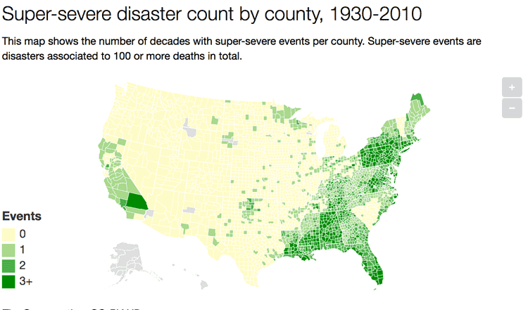
A Look at 90 Years of Natural Disasters by County in the United States
Researchers have mapped out ninety years of natural disasters data by county in the United States.

Using Satellites to Monitor Terrestrial Gamma Ray Flashes
The production of gamma rays that can be seen by satellites are called terrestrial gamma ray flashes, or TGFs.

Adonis: Europe’s Oldest Known Living Tree
A 1,075-year old pine tree known as Adonis is believed to be the oldest tree in Europe.

Great Elephant Census
The group called Elephants Without Borders has recently finished a two-year survey of African elephants across the entire continent, known as the Great Elephant Census (GEC).

Find Ocean Features with this Directory
The GEBCO Undersea Features Gazetteer lets users find information about ocean features.
Review | Worlds Fantastic, Worlds Familiar: A Guided Tour of the Solar System
G.T. Dempsey reviews Bonnie J. Buratti's Worlds Fantastic, Worlds Familiar: A Guided Tour of the Solar System.

Global Landslide Susceptibility Map Highlights Overlooked Regions of the World
NASA satellites and imagery can detect where in the world landslides are likely to occur based on geographical features and the amount of precipitation that has fallen in the area.

Online Atlas Tracks Ecologically Troubled Areas of the World
A new atlas produced by Richard Weller from the University of Pennsylvania tracks how urban sprawl and human activities are endangering bioregions on Earth.

Seven Words to Know About Squirrels
Here are seven words anyone who loves to learn about squirrels should know.

Kambalny Volcano Erupts for the First Time in Almost 250 Years
While the Kamchatka Peninsula has the highest concentration of active volcanoes on Earth, until recently the Kambalny Volcano had been dormant for almost 250 years.

Zealandia: the World’s 8th Continent
As it turns out, we might have one more continent to add to Earth’s collection. The continent, dubbed Zealandia, is composed of nearly 5 million square kilometers of land including New Zealand and New Caledonia and is mostly underwater.

Mercury Levels Greatest Among Marine Birds in Western North America
A research study has identify areas in North America that are hotspots affecting mercury blood levels in birds.

Restoring a Salt Marsh
The San Francisco Bay was once connected to a large salt marsh that contained many different and rare species of plants and animals. Conservationists are now restoring the salt marsh.
Red Sprites and Blue Jets: Electrical Storms in the Upper Atmosphere
Known as red sprites and blue jets, these electrical storms shoot lightening up into space towards the outer edges of Earth's atmosphere instead of towards the surface of the Earth.

These Extremophiles Produce Brilliant Colors
An extremophile is an organism that can live in extreme physical or geochemical conditions.

Study Examines Trends in Global Warming
A multi-institutional study has recently come out with new research that studied the temporary slowdown of rising temperatures around the Earth.

Geography and Paleoclimate
Paleoclimate has had a major effect in shaping not only physical geography but also biodiversity in different parts of the Earth.

Polar Bears Can Be Found in Which Countries?
Learn about which countries contain the habitat range of the polar bear as well as a map of the polar bear habitat.

The Importance of Geomorphology for Physical Geographers
Geomorphology is the study of Earth’s landforms created by mostly physical processes.

Geography Mnemonics to Help Learn About the Great Lakes
Learning the names of the Great Lakes can be aided through the use of mnemonics, a learning device that uses patterns to help with recall.

What Causes Gaps in the Clouds?
Air will rise and fall around large geographic features such as islands and icebergs, affecting the formation of clouds.

Where are the Desolation Islands?
Located in the southern Indian Ocean off the eastern coast of Africa and just north of Antarctica, the Kerguelen Islands have earned the nickname "Desolation Islands" due to their remote location.

Adapting to Live in a Hypersaline Environment
In their field work, the Iranian and French researchers encountered a Günther’s sea snake in the Persian Gulf, beyond what was thought to be its geographical range.

Satellites Delve into the Depths of One of the Earth’s Largest Ecosystems
Satellite imagery is helping marine scientists gain new understanding of ocean ecosystems.

Measuring the Ocean’s Magnetic Field with Satellites
The European Space Agency’s Swarm satellites are investigating the Earth’s magnetic field and the part that shifting ocean tides play.

NASA: September 2016 Warmest on Record:
Nasa’s Goddard Institute for Space Studies (GISS) has announced that September 2016 was the warmest September ever recorded around the globe.