
Physical Geography
Physical geography focuses on geography as an Earth science (and is sometimes called Earth System Science).
Physical geography is a branch of geography that focuses on the study of the natural features and processes of the Earth’s surface. It includes the examination of landforms, climate, vegetation, soils, and water resources. Physical geographers use a range of scientific methods and tools to analyze and understand the complex interactions between the Earth’s physical systems.
Learn about the different branches of geography that fall under the physical geography category: climatology, geomorphology, biogeography, and more.

Coldest Temperature of Clouds Recorded by a Satellite
Researchers measured the coldest temperature ever recorded by a satellite of a cloud.

Tracking Plastic in the Air
Approximately 1,100 tons of microplastics are thought to be floating in the air above the Western United States

80% of Plastic in the Ocean Comes From 1,656 Rivers
A team of researchers analyzed where geographically rivers are the biggest sources of plastic pollution entering the ocean.

Climate Change and the Expansion of Ghost Forests
Along the geography of the East Coast of the United States, large swathes of forest are declining at increasing rates.

Largest Alpine Lake in North America
Located in the Sierra Nevada mountain range, Lake Tahoe is a freshwater lake that straddles the border between California and Nevada.

Geography of Hailstorms in the United States
While hail can form anywhere in the United States experiencing a thunderstorm, geography influences where hailstorms are more likely to occur.
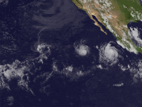
Fujiwhara Effect: When One Storm Absorbs Another
When two storms move towards another, an uncommon phenomenon called the Fujiwhara Effect can happen.

Plateaus in Geography
A plateau is a flat section of land that is sharply raised in contrast to the surrounding landscape on at least one side.

Half of the United States Will Continue to be Affected by Drought for Spring 2021
Drought conditions in much of the United States are forecasted to continue for spring 2021.

North American Continental Divide
The North American Continental Divide separates the watersheds that flow into the Pacific Ocean and those that flow into the Gulf of Mexico and the Atlantic, Caribbean, and Arctic Oceans.

How Much Would the Ocean Rise if Everyone Sat in it?
If everyone in the world decided to sit in the ocean all at once, how much would the sea level rise?

How San Francisco’s Geography and Microclimate Affect Baseball
San Francisco's geography shaped the microclimates that affected baseball at Candlestick Park.

The Earth’s Only Active Volcano Known to Emit Natrocarbonatites
Only one active volcano in the world is known to emit natrocarbonatite.

2020 Hurricane Season
Each year, the World Meteorological Organization creates a list of official names for major storms in the both Northern Pacific and Atlantic oceans.

Billions of Cicadas Will Be Emerging In the United States
Starting sometime in April or May, depending on latitude, one of the largest broods of 17-year cicadas will emerge from underground in a dozen states.

Anthropause: The Impact of Covid-19 Related Slowdowns on Wildlife
Human-animal relations are extremely complex, and our presence - or absence - has greater power over the population dynamics than we commonly think

How Oxbow Lakes Form
An oxbow lake is a uniquely shaped lake resulting from the path of a meandering river.

Sky Islands
Sky islands are like islands of unique ecosystems surrounded by contrasting environments.

From the Arctic to Mexico: Tracking the Epic Migration of Birds
In winter, more than 1 million shorebirds that breed in the Arctic will visit and move throughout the coastline of northwest Mexico.

Eco-fusion: the Mixing of Native and Non-Native Species
Species have moved (and have been moved) around the planet recombining to establish new or “novel” mixes of native and non-native species.

Climate Change is Increasing Post-Wildfire Landslides in Southern California
A recently published study has forecasted that climate change is driving increased wildfire and landslide risk in Southern California.

The United States Ranks Third for Historically Active Volcanoes
The United States ranks behind Indonesia and Japan for historically active volcanoes based on written records.

Review | Yellowstone Wolves: Science and Discovery in the World’s First National Park
This book is a collaborative effort to investigate the successes and failures of the re-introduction of wolves to Yellowstone National Park

Mount Etna Erupts
Mount Etna's latest eruptions occurred on February 16 and again on February 18, 2021.

The Polar Vortex is Causing Extreme Cold in Parts of the United States
A disruption of the polar vortex has allowed extremely cold air to descend to over parts of North America as far south as Texas.