
Google Maps
How to Track Santa Claus in 2023
Learn about the history of tracking Santa's Christmas travels and how to follow Santa using NORAD's app.

You Are Here: How Google Improves Mobile Location Accuracy
Ed Parsons explains how Google continues to innovate in the location technology sector.

Halloween GIS Fun
Looking to add a little geo to your Halloween beyond the proliferation of Halloween Trick or Treater online maps? Halloween ...

How Much Would You Need to be Paid to Give Up Digital Maps?
A trio of economists sought to figure out just how much money it would take users to give up digital services like Google Maps.

How to Find the Latitude and Longitude of a Location Using Google Maps
This tutorial will take you step-by-step through the process of finding the X,Y coordinates of a specific location using Google Maps.

Celebrating Valentine’s Day, Geographer Style
What better way for geographers to say "Happy Valentine's Day" than with geography? Nature supplies us with plenty of heart shape topography found around the world. Heart shaped islands, vegetation, and lakes make up this love themed geography article.

Map of the Earth’s Antineutrino Glow
A new map of antineutrino emissions has been created by scientists using data collected by detectors in Italy and Japan.

How to Make a Map from a Shapefile Using Google Fusion Tables
This tutorial shows you how to make a map in Google Fusion Tables with shapefile data.

How to Make a Map with Excel Data Using Google Fusion Tables
This article will take you though a step-by-step example of using an Excel spreadsheet that contains location information to make a map using Google Fusions Table.


Spatial Unmapped
Geographic maps aren't the only means by which to communicate spatial information.

Interactive Maps of Billionaires
Three interactive maps showing the locations of billionaires around the world.
Geography of Billionaires: Mapping Nationalities and Residency
Forbes recently released an updated list of the world’s billionaires. The listing contains the ranking for 1,226 individuals and families ...

Using GIS to Showcase College Acceptance
Every June, my local paper is filled with the local private school announcements containing lists and lists and lists of ...
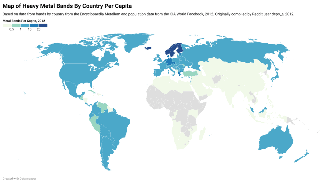
Interactive Map of Heavy Metal Bands By Country Per 100,000 People
Map and table showing where heavy metal bands are the most dense when compared against a country's total population.

Mapping the World at Night
Earth observation satellites are tracking nighttime lights around the world.
Open MapQuest
Google’s recent enforcement of Google Maps API usage, resulting in charges for those exceeding the stated free usage quotas, has ...

Historical Geography and GIS
Historical GIS is the use of GIS data to document the given geography of an area in history. GIS can ...

Online Mapping Sites
Web mapping is now vital to most people, providing virtual geography and driving directions on a daily basis.

Google MapsGL
GoogleMapsGL which combines Google Maps and Web Graphics Library (WebGL) brings 3D graphics to web browsers without the need to install 3D software.
Geocoding Shortcut: Google Maps to ArcMap
Geocoding a dataset to produce a georeferenced layer requires access to a basemap to which the location data is tied. ...

Sometimes Sunrise Doesn’t Exist: Controversial Decisions to Remove Towns from Maps
For about a month, the Florida city of Sunrise was mysteriously missing from Google Maps.

Mapping Out Geotagged Photos
These cartographers have mapped out geotagged photos to show areas where the most pictures by tourists have been taken.
Free Spreadsheet Geocoding
If you have a spreadsheet such as a Microsoft Excel file containing address or x,y coordinates and you want to make a quick map, BatchGeo is a free and easy online application that will convert your location data and geocode it onto Google Maps.

First American Spatial Solutions and Parcels
FASS has promoted their ParcelPoint® GIS database and associated technologies, featuring a nationwide parcel database with over 120 million parcels, now approaching 122 million, as highlighted by their vice president and general manager, Scott Little.
Privacy in GIS Issues
The increase usage of GIS and associated geospatial technologies has brought with it a rise in public concern over privacy. ...