
Caitlin Dempsey

How Many Trees are There in the World?
According to the latest research, the total number of trees in the world is 3.041 trillion (that’s 3,041,000,000,000). The revised number is ...
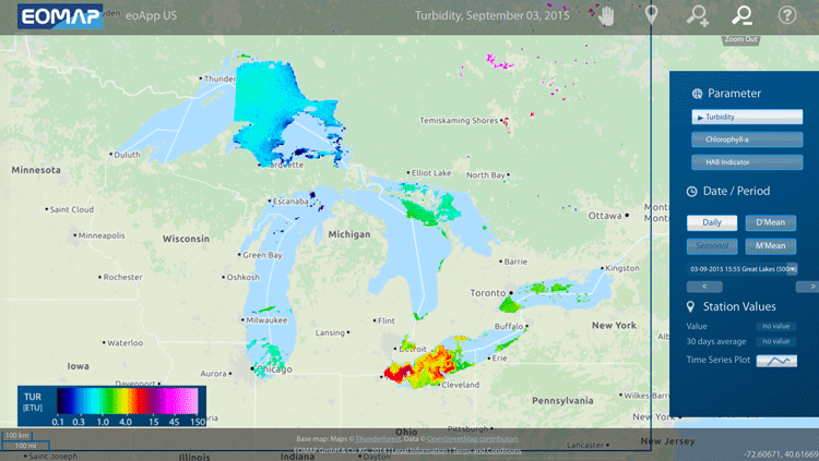
Mapping Algal Blooms in Lake Erie
EOMAP has released a mapping application designed to track algae blooms in Lake Erie.
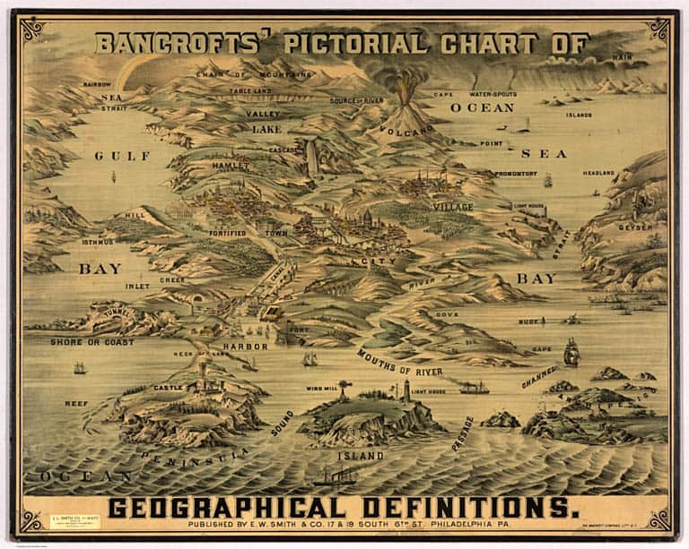
Geography Terms Visualized
This chart by the Bancroft Company from around 1870 defines a range of geographical terms.

Geography of Tree Extremes
Where are the tallest, largest, and oldest trees in the world?


Geography of Fortune 1000 Companies in 2015
This article takes a look at the basic geographical distribution of Fortune 1000 companies in 2015 by state, city, and ZIP code.

Fortune 1000 Companies List for 2015
Below is an excerpt from the list of Fortune 1000 companies for 2015 and is shown to demonstrate the locations ...

River Width GIS Data Created from 1,756 Landsat Images
Researchers used 1,756 Landsat images to develop a GIS database of river widths for the entire North American continent.

Tile Grid Maps
One issue with choropleth maps is that geographic areas that are small in area can oftentimes become indecipherable when viewed on ...

Conjunction Junction Found in the Brain: Helps with Spatial Navigation
Researchers at the University of California, San Diego have identified the area of the brain, the retrosplenial cortex, that helps put together the necessary spatial information for navigation.

A Modern Statistical Atlas of the United States with an 1870s Twist
Modern data maps of the United States based on government data, produced to look like maps created in the 1870s.

Five Books About the Arctic for Early Readers
Discover the Arctic with these 5 captivating books! Perfect for emerging readers (5-8 yrs) seeking adventure in the frozen wilderness.

First Satellite Images from Sentinel-2 Delivered
Four days after its launch, the first images from Sentinel-2 have been delivered. Covering an area from central Europe and the ...

Landsat 8 Data Users Handbook
Launched in 2013 by NASA, Landsat 8 is the latest satellite in the series. The mission of the orbiting satellite is ...

Leap Second to be Added June 30, 2015
On Tuesday June 30, 2015, the day will be a second longer than usual. Similar to how February gains an ...

How Do Jet Contrails Affect Local Climates?
Do jet contrails have an effect on local temperatures?

Using Drones to Protect Indigenous Lands
Indigenous Dayaks in Setulang, Indonesia are using drones to quickly and cheaply map their territories for defending against trespassers.

Map of Global Lightning Strikes
NASA has created a world map showing the intensity of lightning strikes from 1998-2013.

Tracking Public Perception about Climate Change
The Yale Climate Opinion Maps track public opinion among adults on attitudes about climate change.

Geographic Spread of the Indo-European Language Family
A recent study by the Australian Centre for Ancient DNA and Harvard Medical School looked at the initial dissemination of Indo-European languages.

Geoportals
Geoportals provide a single point of access for searching for and downloading GIS data from a multitude of sources. Users looking for GIS ...

New GISP Certification Process and Fees Announced
The GIS Certification Institute (GISCI) announced new terms and fees for its certification and recertification processes starting July 1, 2015.

The World’s Largest Mass Migration
Surrounding the Chinese New Year is a forty-day travel period known as "Chunyun," meaning “Spring Festival Transport”. Each year, Chinese officials calculate that well over 3 billion passenger trips occur during this period and overwhelms the Chinese transportation system.

Abstract Machine: Applying GIS in the Humanities
In Abstract Machine: Humanities GIS, Charles B. Travis, a senior research fellow at Trinity College Dublin in Ireland, uses case studies from history, poetry, and published works to explore out GIS analysis is used to explore and understand events in literature, history, and culture.

Esri Launches Site to Find Open Data
Esri has launched ArcGIS Open Data as a portal for users to search, download, and visualize open data: Since July 2014, ...