
Caitlin Dempsey

This Interferogram Shows Ground Displacement in Italy as a Result of the Recent Earthquake
The European Space Agency posted an interferogram showing ground displacement as a result of the recent earthquake in Italy.

View Landsat 8 Imagery With This Free Tool
Users can search, view, and access Landsat 8 imagery with this free online web viewer developed by EOS Data Analytics.

Norwegian Mapmaker Wants to Give a Mountain to Finland for its 100th Birthday
A retired Norwegian mapmaker has proposed that Norway shift its border 660 feet (200 meters) in order to gift the mountain of Halti to Finland in honor of its 100th anniversary independence.

Which Continent Lies in All Four Hemispheres?
While several of the world's continents are traversed by the separation between two hemispheres, there is only one continent in the world that lies in all four hemispheres: Africa.

After the Map GIS Data Available
A bonus to the book, After the Map, is the companion site, www.afterthemap.info which offers access to all of the imagery, spreadsheets, and GIS data used in the book.

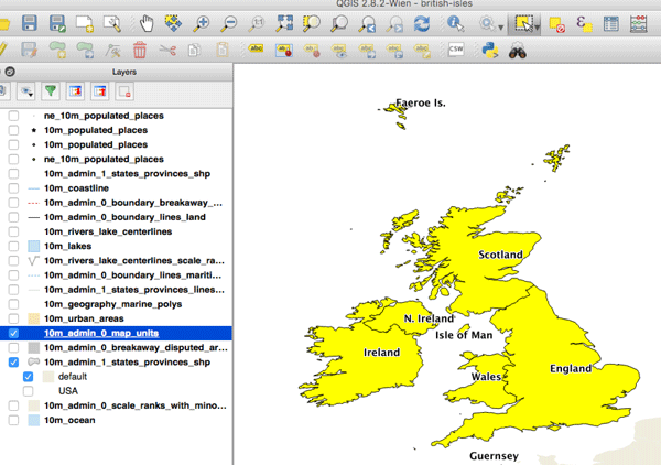
What is the Difference Between The United Kingdom and Great Britain?
This article outlines the differences between the United Kingdom (also known as the UK), Great Britain, and the British Isles.

What is Point Nemo?
Point Nemo is a pole of inaccessibility that marks the furthest location from the ocean to the nearest coastline.
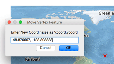
How to Map a Single Set of Coordinates Using QGIS
Here are the steps you need to follow if you want to map a single set of coordinates with QGIS.
How to Convert a Selection into a New GIS Dataset Using QGIS
Here is a step-by-step tutorial on how to convert a geographic selection from one GIS dataset into a new GIS file using QGIS.

How Many Lakes Does Switzerland Have?
Learn about how many lakes there are in Switzerland and which lake is the largest.

Terrapattern: Search Engine for Satellite Imagery
Terrapattern lets users perform "similar-image" searches in unlabeled satellite imagery using deep learning machine vision techniques.

Explore the Literary Geography of London
Authorial London is a project that geolocates geographic references about London from writers that have lived in the United Kingdom's most populous city.

Isodistance and Isochrone Maps
Isodistance measures routes of equal time and isochrone measures routes of equal travel times although both are typically represented as bands of polygons.

Color Maps to Your Heart’s Content With this City Maps Coloring Book
City Maps: A coloring book for adults is a 94-page book containing 44 maps covering cities from around the world.

How to Remember the Difference Between Latitude and Longitude
Here's a simple way to remember the difference between latitude and longitude and which comes first when you encounter a set of coordinates.

Is Sexism a Problem in GIS?
This article takes a look the state of sexism in GIS and reports how those working in the field have spoken about how sexism has impacted them.

Fortune 1000 Companies for 2013
Sortable list of the top 50 Fortune 1000 companies from 2013. Fortune 1000 companies can be filtered by state.

A Look at GIS Salaries
Learn about the average GIS salaries for GIS technicians, analysts, developers, and more.

Landlocked Countries in South America
Learn about which countries in South America are landlocked.

Geographic Profiling of Banksy
Scientists at Queen Mary University of London have used spatial profiling techniques in an attempt to discover the real identity of enigmatic graffiti artist Banksy.
Geography of Fortune 1000 Companies in 2013
A quick look at the geography of Fortune 1000 companies in 2013. Includes a list of the Fortune 1000 rankings for 2013 which can be filtered by state.

Take Map Design to the Next Level with QGIS
QGIS Map Design provides step-by-step instructions covering both basic styling and labeling and advanced cartographic techniques such as illuminated contours and dynamic masking.

Secure Geocoding
World Geocoder for ArcGIS allows users the ability to secure map out addresses and locations from behind a firewall.

Free Trial of Drone2Map: Turn Drone Imagery into GIS Ready Data
Esri has released its beta version of Drone2Map will enables user to quickly develop GIS ready data from drone imagery.

Calculating Nature’s Tipping Point
A recent paper published in Nature describes a new tool that may provide the answer to modeling collapse in biological and technical systems on Earth.

Volunteer to be a Digital Humanitarian and Help With Mapping Projects
The Humanitarian OpenStreetMap Team is able to provide mapping services in large part due to its army of volunteers. Find out ways that you can get involved with HOT.