
Caitlin Dempsey
Geography of Google Search
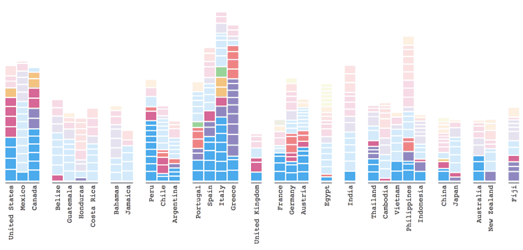
Explore Adventure analyzes where and when people in different countries search for locations in other countries.

How the ‘Quirky Geography’ of ZIP Codes Obscured Flint’s Lead Problem
Richard Casey Sadler, an assistant professor at Michigan State University discusses how the Michigan Department of Health and Human Services' reliance on using ZIP Code level data obscured the link between Flint residents and lead exposure.

Online Atlas Tracks Ecologically Troubled Areas of the World
A new atlas produced by Richard Weller from the University of Pennsylvania tracks how urban sprawl and human activities are endangering bioregions on Earth.

World’s Longest Piers
Learn about the world's largest disembarkation pier, wooden pier, and pleasure pier.

Create Custom Map Projections
Flex Projector is a free and open source, platform agnostic software application that lets users upload GIS data and create customized small scale global map projections.

A Global Landslide Potential Map That Updates Every 30 Minutes
Researchers from NASA have developed a global landslide susceptibility model that maps out areas in danger of potential landslides every thirty minutes.

Seven Words to Know About Squirrels
Here are seven words anyone who loves to learn about squirrels should know.

Kambalny Volcano Erupts for the First Time in Almost 250 Years
While the Kamchatka Peninsula has the highest concentration of active volcanoes on Earth, until recently the Kambalny Volcano had been dormant for almost 250 years.

Teaching Context When it Comes to Map Projections
Context is needed in teaching about distortion created by different map projections.

Understanding Ocean Wave Patterns from Satellite Imagery of Sun Glitter
Researchers have developed a method by which to translate satellite imagery of sun glitter on the water into data about the direction, height and movement of waves.

ESA’s Swarm Satellites Reveal Detailed Variations in the Earth’s Magnetic Field
Three years of data collection the European Space Agency's (ESA) Swarm satellites has resulted in the highest resolution map of Earth’s lithospheric magnetic field.

Color to Your Heart’s Delight With These Historical Map Coloring Pages
Relax and reduce your stress by printing out and coloring in these maps.
Parts of the World That Cartographers Keep Forgetting Exist
Some places and countries seem to be frequently left off of maps because cartographers keep forgetting they exist.

Using Visual Search to Find Geographically Similar Features on Satellite Imagery
Descartes Labs recently unveiled its GeoVisual Search application which uses machine learning to visually search satellite imagery for similar geographic features.

Geography of Global 500 Companies in 2016
Find out which countries, cities and US states have the most Global 500 countries in 2016.

View the Human Footprint on this Rotating Globe
View the global human footprint map developed from 180,000 satellite images.

How to Create a Non-contiguous Cartogram Using QGIS
This article presents a rough idea of how one might mimic a non-contiguous cartogram using QGIS.

Creating Non-contiguous Cartograms
Non-contiguous cartograms are a type of area cartogram. In a non-contiguous cartogram, the features are not connected and enlarge or shrink based on a quantified value.

Celebrating Valentine’s Day, Geographer Style
What better way for geographers to say "Happy Valentine's Day" than with geography? Nature supplies us with plenty of heart shape topography found around the world. Heart shaped islands, vegetation, and lakes make up this love themed geography article.
Red Sprites and Blue Jets: Electrical Storms in the Upper Atmosphere
Known as red sprites and blue jets, these electrical storms shoot lightening up into space towards the outer edges of Earth's atmosphere instead of towards the surface of the Earth.

These Extremophiles Produce Brilliant Colors
An extremophile is an organism that can live in extreme physical or geochemical conditions.

This Map Shows That By 1907, Only 11 Car Trips Across the United States Had Been Made
In 1907, a three-volume publication of the Blue Book included a map showing the 11 recorded transcontinental trips that had been made to date.

Polar Bears Can Be Found in Which Countries?
Learn about which countries contain the habitat range of the polar bear as well as a map of the polar bear habitat.

The History of Mapping Disease
Cartographies of Disease: Maps, Mapping, and Medicine takes a look at how cartography and GIS have been used to map and combat devastating diseases such as cholera, yellow fever, and Ebola.

MapInfo Resources
Here are some suggestions for peer support and resources offered for users of MapInfo.

Open Data Program Launched by DigitalGlobe
The Open Data program offers high-resolution satellite imagery and crowdsourced GIS layers for large-scale natural disasters.