
Caitlin Dempsey
NAIP Aerial Imagery Might be Moved from the Public Domain to a Licensing Model
The Farm Service Agency (FSA) is considering moving its National Agriculture Imagery Program (NAIP) from a free aerial imagery service to a licensing model starting the 2019 fiscal year.

Hurricane Ophelia is the Strongest Hurricane to Form East of the United States
On Saturday, October 15, 2017, Hurricane Ophelia strengthened to Category 3 status making it the first recorded eastern hurricane to be this strong.

Blooms and Scums in Lake Erie
This Landsat 8 satellite image captures a huge bloom that has been occurring in Lake Erie since mid-July, 2017.

How to Animate a Route on a Map Using Photoshop
Here is a step-by-step tutorial showing you how to animate a route on top of an image of a map using Photoshop.

Open Data Site Established for Hurricane Harvey
An open data site has been set up to house GIS data from authoritative sources relating to Hurricane Harvey.

Tracking Hurricane Harvey with Satellites
Several satellites have been tracking and measuring the intensity of Hurricane Harvey.

Researchers are Using Machine Learning to Better Predict Weather Patterns
The enormous amount of data from Earth-observing satellites is pushing researchers to use machine learning to mine the information and improve climate models.

Can Painting City Streets Reduce the Urban Heat Island Effect?
The City of Los Angeles is experimenting with lowering the urban heat island effect by painting its streets a lighter color.

Digitizing Errors in GIS
Digitizing in GIS is the process of converting geographic data either from a hardcopy or a scanned image into vector GIS data by tracing the features. Explained in this article are the types of common digitizing errors found when creating geographic data within GIS.

You Can Help the Humanitarian OpenStreetMap Team With Its Research on Crowdsourced Damage Assessment
The Humanitarian OpenStreetMap Team recently launched three formal research experiments on crowdsourced damage assessment and is seeking volunteers interested in participating.

Landlocked Countries
Learn about how many countries are landlocked, which is the largest landlocked country, and which two countries are double landlocked.

Information Services and the User Experience in the Geographic Information Community
Members of the geographic information community can be considered heavy users of information services. Geographic information (GI) users are “super-encounterers” ...
Information Needs and Information Seeking Behavior Within the Geographic Information Community
As part of the Professional and Occupational information community category (Hansen 2014), members of the geographic information community can be ...

The Geographic Information Community
At its broadest definition, the geographic information community (GIC) is a community of users who are connected by the common interest in visualizing and analyzing spatial (or geographic) information.

Dress Up Your QGIS Install With this Whimsical Plugin
The QGIS hats plugin is a bit of fun that accomplishes no other purpose than to add a hat to the QGIS icon.

These Two ArcGIS Books are Free from Esri
Esri offers two free ArcGIS books: '10 Big Ideas about Applying The Science of Where' & 'Instructional Guide for The ArcGIS Imagery Book'.

Model Predicts Economic Damage from Climate Change to be Greatest in the South in the US
A new model maps out the agriculture, crime, coastal storms, energy, human mortality, and labor costs of climate change in the United States.

By Using High-resolution Satellite Imagery to Survey Drylands, Researchers Boosted Estimates of Global Forest Cover by 9%
Researchers, using high-resolution satellite imagery, have discovered there is about 40-47% more forest cover in dryland biomes than previously thought.
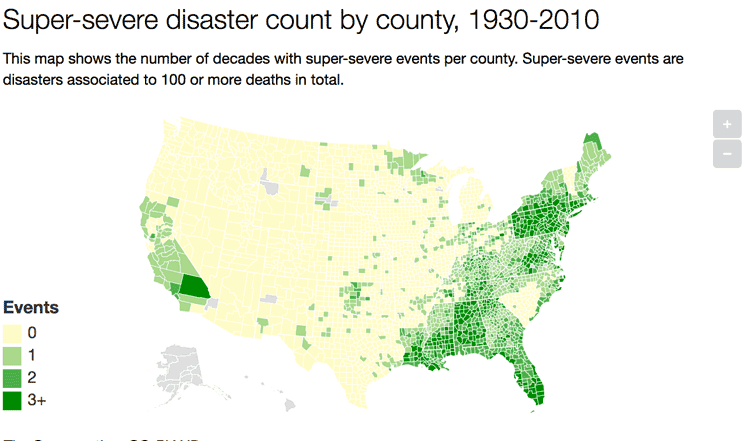
A Look at 90 Years of Natural Disasters by County in the United States
Researchers have mapped out ninety years of natural disasters data by county in the United States.

Be Aware of the Proposed Geospatial Data Act (GDA) of 2017
The Geospatial Data Act (GDA) of 2017 is being reintroduced in Congress. Passage of this bill would have a severe impact on the GIS industry.

This Globe Unfolds Like an Umbrella
John Betts's 15 inch (37.5 cm) diameter collapsible globe expanded much like the mechanism by which an umbrella unfolds.

Medieval Irish and Colorful Winds
Medieval Ireland attributed a different color for each of the cardinal and ordinal directions of the wind.

Mapping Urban Trees and Income in Manhattan
This article analyzes tree and income data for the New York City borough of Manhattan.

How to Find the Latitude and Longitude of a Location Using Google Maps
This tutorial will take you step-by-step through the process of finding the X,Y coordinates of a specific location using Google Maps.

Digital Hegemony: How Local Your Google Search Results are Depends on the Country
Researchers took at look at search results on Google for 188 capital cities to see the country of origin for the top results.
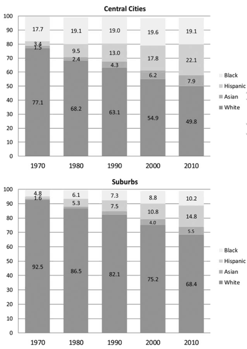
Racial Diversity Still Lacking in US Suburbs Per Study
A study out of Princeton University has found that United States suburbs are still mostly dominated by white residents.