
Caitlin Dempsey

Extreme Fish Stocking: Repopulating Lakes by Air
To repopulate remote lakes, Utah's Division of Wildlife Resources (DWR) uses airplanes to drop fish into lakes.

PaleoDEMs: Map the Earth’s Changing Topography Over the last 540 Million Years
Users can download paleogeographic datasets reconstructing paleotopography and paleobathymetry dating back to 540 millions years ago
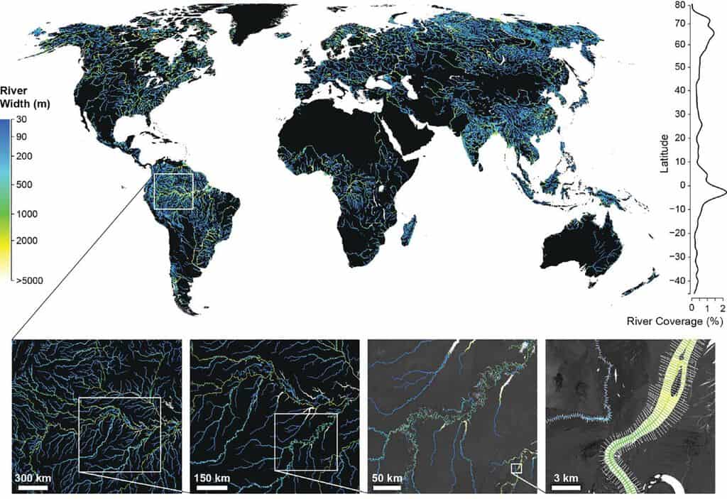
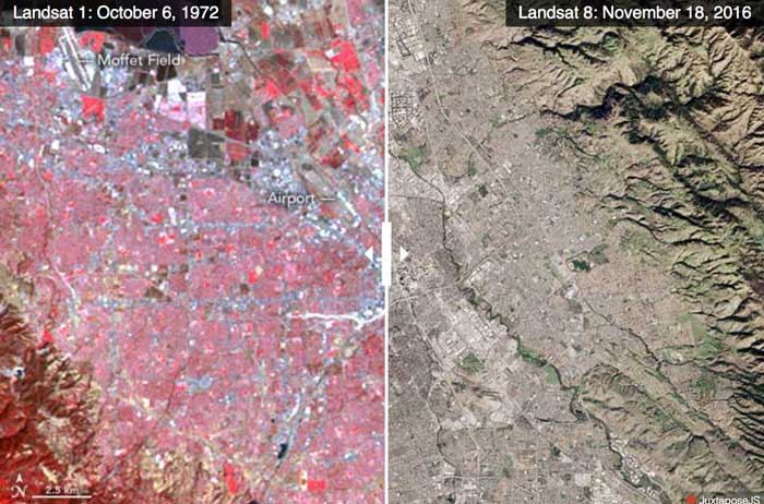
Global Dataset of River Widths Developed from Landsat Imagery
Researchers used a combination of satellite imagery and field measurements coupled with statistical modeling to calculate worldwide river and stream surface measurements which is now available as a GIS dataset.

Interviews with Geographers and Cartographers
Access interviews with prominent geographers from the 1970s to 1990s via the Library of Congress.

Will Self-Driving Cars Make Traffic Worse?
The World Economic Forum and Boston Consulting Group studied the possible effects of autonomous vehicles on Boston's future traffic.

Human Eyesight is Sharper Than It Is For Most Animals
A team of researchers from Duke University assesses the visual acuity of over 600 species encompassing insects, birds, mammals, fish, and other animals.
Cormorant: Raven of the Sea
Cormorants are a family of about 40 aquatic birds, mostly of medium to large size. All species of cormorants are ...
125 Million Building Footprints in the US Now Available as Open GIS Data
Microsoft has made 124,885,597 footprints from all 50 U.S. states available as open data.

Learn to Use GIS to Map and Analyze Surface Water Data
Esri Press recently published a book to teach users how to use GIS to analyze surface water using the National Hydrography Dataset produced by the USGS.

More Animals Are Becoming Nocturnal Thanks to Human Activity
Researchers from UC Berkeley undertook a study that looks at the effect of human activity on the daily activity patterns of wildlife.
QGIS Tutorial: How to Change the Map Projection to be Centered Over the Pacific Ocean
This quick tutorial shows you how to recenter your map project in QGIS so that the center of the map view is on the Pacific Ocean.

How to Use the Color Blind Preview Option in QGIS
With the release of QGIS 3, you can now preview how your maps will look for those with two types of red-green color blindness.

How Much Do GIS Jobs Pay?
Your potential salary as a GIS professional is going to vary depending on several factors such as the location of the job, the title, and experience.
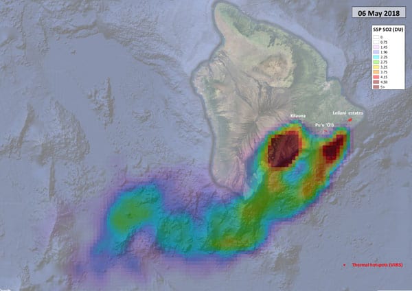
Sentinel-5P Tracking Emissions from Hawaii’s Kīlauea Volcano
Researchers are using data from the Sentinel-5P satellite to map out sulphur dioxide emissions from Hawaii's Kīlauea volcano.

Lava from Hawaii’s Kilauea Volcano Reaches the Ocean
This image captured by the USGS-HVO shows the active ocean entry of a branch of lava from the Kīlauea Volcano in Hawaii.

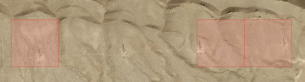
The Aorounga Crater in Northern Chad
The Aorounga Crater is an impact crater located in northern Chad just south of the Tibesti Mountains in the central Sahara desert.

How Much Would You Need to be Paid to Give Up Digital Maps?
A trio of economists sought to figure out just how much money it would take users to give up digital services like Google Maps.

What are Weird Polygons?
The straightforward definition of a weird polygon is a GIS data feature that is missing nodes.
Department of the Interior is Considering Charging for Landsat Data
The Department of the Interior (DOI), which oversees the USGS, has tasked a federal advisory committee with exploring how instituting a fee for Landsat data might impact scientists and other users
Using Machine Learning to Speed Up Electrical Grid Mapping
Development Seed, working for the World Bank Group, created a methodology for integrating machine learning with manual mapping in order to speed up the mapping of high-voltage (HV) grids in developing countries.

Where to Find GIS Data for Historical Country Boundaries
Finding historical GIS data can be hard to find. Listed here are available sites that offer historical country data in GIS file formats.

Review | The Nocturnal City
Robert Shaw's newly published book, The Nocturnal City, is an effort to delve into the city at night which is a “very different time-space from day.”
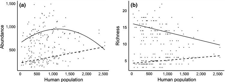
Study Finds a Lower Abundance of Songbirds in Poorer Urban Areas in England
A recently published study looked at the spatial relationship between people and birds across urban areas in Southern England in order to understand patterns of abundance and species richness among birds in populated areas.

King Penguins Like to Maintain Just the Right Amount of Personal Space
Researchers found a liquid-like spacing in King penguin colonies is the result of a balance between territorial pecking and a need to form in large groups as protection against predators.

Viz Palette Helps You Pick Colors for Your Maps and Data Visualizations
There's a new color picker tool to help with selecting a palette for data visualizations.

Marine Heatwaves are Becoming Longer and More Frequent
Researchers, using satellite observations, have found that marine heatwaves are becoming more frequent and longer lasting.