
Caitlin Dempsey

What is the Oldest Surviving Aerial Photograph?
The oldest surviving aerial photograph was taken on October 13, 1860 by James Wallace Black over the city of Boston.

Ground Movement in Norway
Data from InSAR Norway has helped the Geological Survey of Norway learn where there are areas of significant ground movement in both natural and urban areas of Norway.

Mapping Where Norway is Moving
Norway is using Copernicus Sentinel-1 data to detect ground movement across the country.
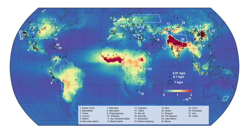
Mapping Out Ammonia Hotspots With Satellite Data
Researchers recently used satellite data to create a high resolution map of ammonia hotspots around the world.

How Much of the Earth is Covered by Clouds?
Exactly how much of the world is covered in clouds?

Changes in Countries and Capital
Listed here are more recently formed countries and capitals that have moved and well as some geography news items about some countries.
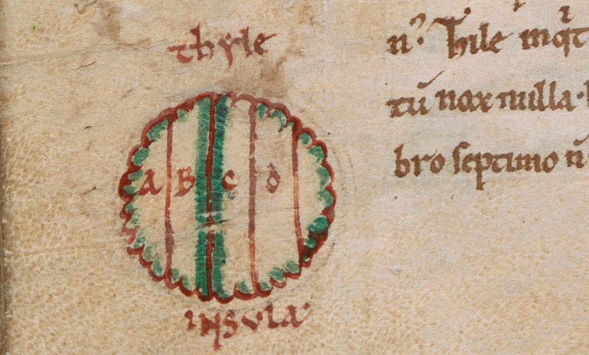
What Does Ultima Thule Mean?
Ultima thule is Latin and has been used over to the centuries to refer to an area of the world that is the most distant and inaccessible.

How To Use the Equal Earth Projection With QGIS on the Mac
Here are a few short steps to set up the Equal Earth map projection in QGIS.

Hand Cut Paper Map of Amsterdam in the Shape of a Leaf
Street artist Nils Westergard created this intricate map of the streets of Amsterdam in the form of a leaf cut out from paper with an X-Acto knife.

PACE: NASA’s Earth Observation Satellite to Launch in 2022
NASA’s PACE (Plankton, Aerosol, Cloud, Ocean Ecosystem) is a planned earth observation satellite with an anticipated launch in 2022.
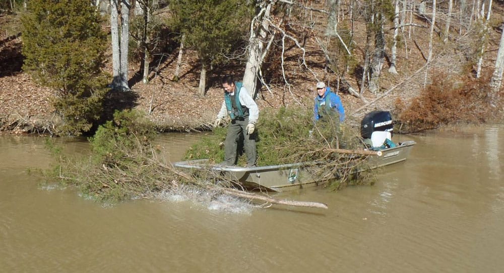
Using Christmas Trees for Habitat Restoration
Upcycling Christmas trees helps to restore fish habitat, restore sand dunes, and supports native marsh grass growth.

This Remote Island Has the Highest Density of Trash in the World
The remote island of Henderson Island is accumulating trash at a rate of 26.8 items per day. With over 671.6 items of debris per square meter along its beaches, this island has the highest density of trash in the world.

Geography Facts About the Mississippi Watershed
The Mississippi watershed is the largest drainage basin in North America.

The Foot-trembling Bird Gets the Worm
Foot-trembling is a foraging technique used by some species of birds to find prey beneath the surface of the ground.

This Lake Looks Like a Christmas Tree
The main body of Lake Dukan takes on a triangular shape that looks like a Christmas tree.

The 2018 Statistic of the Year is About Plastic Recycling
90.5% of all plastics that have ever been produced have never been recycled.

Quickly Make a Map Poster From Any Urban Location on Earth
Figuregrounder by Hans Hack is a fun tool that lets you create a simple map poster in seconds.

Free Urban Planning GIS Book and Exercises
An open access book focusing on the use of GIS in sustainable urban planning and management includes six chapters containing exercises and GIS data.

3D Map of Puerto Rico’s Forest Shows How Hurricane Maria Reduced Tree Height
Researchers who compared before and after LiDAR measurements of Puerto Rico's tropical forests found that Hurricane Maria damaged or uprooted 40-60% of the tallest trees.

Interesting Geography Facts About the US-Canada Border
Here are some interesting geography facts about the Canada–United States border.


These Wolves in Minnesota are Very Very Territorial
Researchers with the Voyageurs Wolf Project released maps showing 68,000 GPS-locations of seven wolves being tracked.

How to Make Map Ornaments and Geography Themed Christmas Decorations
If you want to lend a geographic touch to your Christmas celebrations, check out these ingenious geography crafting ideas.

Using Satellite Imagery to Track Volcanic Ash Clouds
Researchers have developed an algorithm that can distinguish between volcanic and non-volcanic clouds using high-resolution satellite imagery.
The Medieval Physician’s Almanac
During the Middle Ages, the belief that spiritual and cosmological forces affected the body and mind was commonly accepted (BBC, ...

Using Machine Learning and Satellite Imagery for Street Address Generation
Facebook and MIT Labs researchers have developed a method employing machine learning and satellite images to create street addresses in regions lacking unique building addresses.