
Caitlin Dempsey

Urbanization Makes the Surrounding Atmosphere Drier
Researchers in southern China have analyzed the impact of urbanization on local climates, known as the urban dry island (UDI) effects.

Using Dark Fiber to Measure Seismic Activity
Researchers wanted to test if unlit fiber cable could be used to collect measurements of seismic activity to fill in spatial gaps in the data.
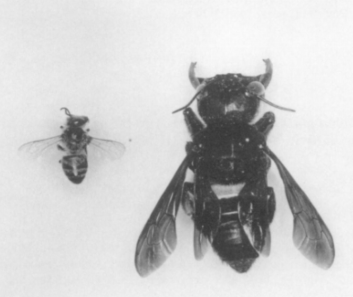
These Two Species Are No Longer Extinct
Recently, two formerly extinct species were separately discovered to still be living.

With Only Numbers and No Street Names, This Norwegian Town is Confusing Tourists
A Norwegian municipality decided to only give the chalets in a development numbers with no corresponding street names.

What are the Benefits of Landsat’s Current Free and Open Policy?
A group of researchers from different universities and government groups have published a study of how Landsat's free and open data policy has benefitted users of the programs satellite imagery products.

What Can You do with a Degree in Geography?
A good geographer should have knowledge of human-environment relationships, spatial and statistical analysis skills, proficiency in data visualization and strong communication skills.

Using Repeat Photography to Capture Landscape Change
By capturing the same view through photography, researchers can study how the landscape is changing over time.
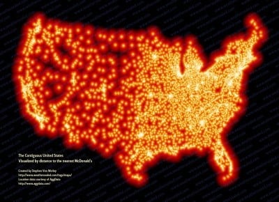
McFarthest in the Lower 48 – Map of McDonald Locations
Stephen Von Worley has mapped 13,000+ locations covering every McDonalds in the continental United States.

USGS 3DEP Lidar Point Cloud Repository Available as an Amazon Public Dataset
Representing trillions of LiDAR points, USGS 3DEP Lidar Point data is now available as an Amazon Public Dataset.

Geography Extremes
Find geography facts about the hottest, coldest, tallest, remote places on Earth.

The Equal Earth Physical Map is Free
Both the physical and political Equal Earth maps are in the public domain which means users can use them however they want to.

Sunday Maptinee: Time-lapse Animation Shows How the World’s Second Largest Atlas Was Digitized
Watch this time-lapse video of the world's second largest atlas being digitized.

Ethiopia’s Church Forests Are Pockets of Biodiversity
Also known as coptic forests, church forests range in size from a few acres to 300 hectares and provide a range of spiritual and ecological benefits to the local community.

What’s the Tallest Point in Niger?
Located in northern Niger, Mont Idoukal-n-Taghes rises to a summit height of 2,022 meters (6,634 feet) above sea level.

ICESat-2: Highest Resolution Laser Altimeter
ICESat-2's purpose is to collect detailed measurements of the Earth's surface using its Advanced Topographic Laser Altimeter System (ATLAS).

This 1835 Map Shows Incredible Detail About the Longest Cave System in the World
In 1835, Cincinnati-based surveyor Edmund F. Lee created this elaborately detailed map of Mammoth Cave.

Updated World Magnetic Model To Be Released
An acceleration in the Earth's magnetic field has triggered an early update to the World Magnetic Model.

Waipā Garden in Kauai, Hawaii Now Holds the 24-Hour Precipitation Record for the United States
A rainfall gauge located at the Waipā Foundation in Kauai, Hawaii set the record for the most rainfall in a 24-hour period in the United States.
What is Necrotecture?
Necrotecture is an urban planning coined termed by Rowland Atkinson to describe the "dead residential space" created by a high density of mostly vacant residential dwellings.

Over 600 Maps Added to South Dakota Digital Archives
The South Dakota State Historical Society has made over 600 maps available online with the South Dakota Digital Archives.

Before There Were Drones: Using Pigeons for Aerial Photography
Back before drones became a cheap and easy way to acquire aerial imagery, a German inventor proposed using pigeons to capture photographs of the earth from above.
GIS From the Past: CARETS
In the early 1970s, a joint pilot project between NASA and the USGS sought to test out the feasibility of integrating data from Landsat and high-altitude aircraft sensors into a regional land use database.

Who Coined the Term ‘Remote Sensing’?
While the origins of remote sensing can be traced to World War II's use of radar, sonar, and thermal detection technologies, the use of the term 'remote sensing' wasn't coined until the late 1950s.

Antarctica is Losing Ice Six Times Faster Than 40 Years Ago
Researchers analyzed ice mass between 1979 and 2017 in Antarctica and found a sixfold increase in yearly ice mass loss.

Atmospheric Rivers
Atmospheric Rivers are trails of moisture in the atmosphere composed of condensed water vapor.

Tracking Ocean Currents With Seabirds
A group of researchers wanted to test if drifting seabirds could offer a novel way of collecting data about sea current velocity and direction.