
Caitlin Dempsey

Online Landslide Inventory Mapping Tool
The USGS has launched an online web map that compiles existing United States landslide data into a searchable tool called the U.S. Landslide Inventory Map.

An Iceberg the Size of Greater London Has Broken Off Amery Ice Shelf in Antarctica
An iceberg the size of Greater London recently broke off the from Amery Ice Shelf in Antarctica.
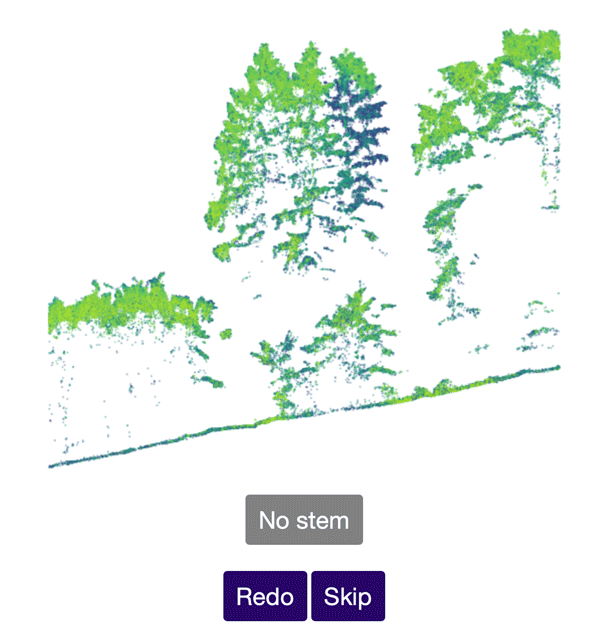
Help Identify Tree Stems from Drone Data
The Tree Mapping project uses crowd sourcing to accurate identify tree stems from laser scanning point cloud data acquired via UAV.

Satellite Imagery Shows How Much of South Dakota’s Flooded Fields Were Unable to be Farmed
In August of 2019, the U.S. Department of Agriculture reported that South Dakota had 3.9 million “prevented planting” acres.

Indonesia Will be Moving Its Capital
Driven by congestion and the gradual sinking of Jakarta, Indonesia announced that it will be moving its capital to a location on the island of Borneo.

How to Calculate the Boundaries of an UTM Zone
A UTM coordinate system's eastern and western borders can be easily determined.

New Study Maps Out the Global Pattern of Soil-based Carbon Storage
Researchers from the Crowther Lab recently published a study in Science which reviewed existing research on soil communities and how climate change will accelerate the loss of carbon stored in the world's soil.

Caltrans Plans to Build the World’s Largest Wildlife Crossing in California
With a proposed design spanning 200 feet (61 meters) across the 101 freeway, Caltrans in Southern California is moving along with plans to build the world's largest wildlife crossing and the first of its kind near a major city.


Geography Facts About the Amazon River
The Amazon River is one of the world's longest and largest rivers. Here are some interesting geographical facts about the Amazon River.

What’s on the Other Side of the World?
The spot diametrically opposed to a location on Earth is called the antipode.

These Two Satellite Images Highlight the Disappearance of a Glacier
Okjökull was once a large glacier in Iceland located in western Iceland on top of the volcanic mountain Ok.

Version 3 of the ASTER Global Digital Elevation Model Released
2.3 million scenes from the ASTER archive were processed to create the latest version of the ASTER Global Digital Elevation Model (GDEM).

What Skills Does a Geographer Need?
To be a successful geographer, certain skills are needed in order to be able to understand the Earth’s physical environment as well as human patterns and processes.

GPS Tracking Shows That Black Bears Avoid Humans During the Day
A recent study found that American black bears tend to become more nocturnal during spring in summer to avoid interacting with humans as they search for food.

The U.S. is Losing 36 Million Trees Per Year
A study from the US Forest Service has found that, nationally, tree cover is declining at a rate of 175,000 acres per year which is the equivalent of about 36 million trees lost each year.

Gulf of Mexico Remains the Second-largest Low-Oxygen Dead Zone on Earth
A newly released forecast by the National Oceanic and Atmospheric Administration (NOAA) has predicted that the Gulf of Mexico will again become the second-largest low-oxygen dead zone on after (after the Baltic Sea).

The Northernmost Permanently Inhabited Spot on Earth
Located 817 kilometers (508 mi) from the North Pole, Alert (82°30'05" ) is the northernmost place with a permanent (year-round) population.

Japan’s Highest Mountain
At 3,776 meters (12,389 feet) tall, Mount Fuji is Japan's highest mountain.
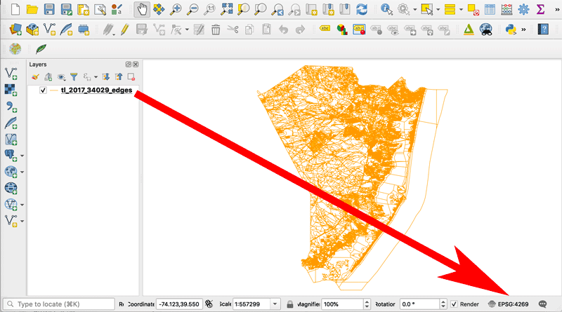
How to Change the Projection of a Shapefile Using QGIS
If you know your shapefile's beginning coordinate system or projection, you can export the data using QGIS.
With the Help of GPS Trackers, 40 Tons of Trash is Removed from the Pacific Ocean
Ocean Voyages Institute (OVI), a nonprofit, recently collected 40 tons of trash from the Pacific Gyre.

NASA is Expanding its Worldwide Landslide Data Catalog Using Volunteers
NASA has developed Landslide Reporter as a way to collect as much information as possible about landslides from citizen scientists from around the world.
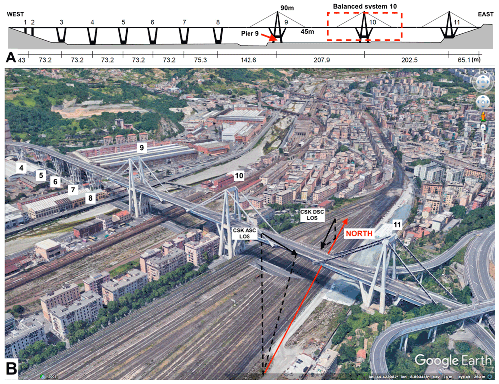
Using Remote Sensing to Detect Structural Changes in Bridges
Researchers are using synthetic aperture radar (SAR) collected from satellites to detect structural changes in bridges.

Mapping Ground Movement From the 2019 California Earthquake with Satellite Data
Researchers with NASA's Jet Propulsion Laboratory have used satellite data to map out surface displacement from the 2019 California earthquakes.

New GIS Dataset: Forest Carbon Stocks for the Western United States
Covering 11 states, this GIS dataset contains annual estimates of carbon stocks, fluxes, and productivity for Arizona, California, Colorado, Idaho, Montana, Nevada, New Mexico, Oregon, Utah, Washington, and Wyoming.

First Practice Exam for GISP Certification Released
A practice exam for the GISP certification has been release which contains 50 questions broken down in the six knowledge categories.