
Caitlin Dempsey

An Incredibly Detailed Map of the Moon’s Geology
Entitled, "Unified Geologic Map of the Moon" the newly created map summarizes the current state of lunar geologic knowledge.

Geography Facts About the Pacific Ocean
Learn some geography facts about the world's largest ocean.

Driest Non-polar Desert in the World
Situated in northern Chile, the Atacama Desert is one of the driest places on Earth.

Voyant: Online Text Analysis Tool
Voyant is an online text analysis tool that allows users to enter one or more URLs, a block of text, or a set of text documents, and see the results of terminology used.

Mapping the Transportation Network of the Roman World
ORBIS is a mapping project developed by researchers at Stanford that reconstructs the financial and spatial challenges of transporting goods and people during Roman times about 200 CE.

Why Do Iguanas Drop From Trees When It’s Cold in Florida?
Occasionally, the temperature in southern Florida approaches freezing, leading to falling iguanas.
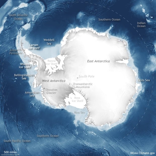
Geography Facts About Antarctica
Learn interesting geography facts about the continent of Antarctica, the driest, coldest, highest continent on Earth.

GeoQuiz: Pioneering Geographers
Take this quiz to test how well you know about the contributions of these geographers.

Spring Bird Migration is Happening Earlier for Some Birds
With changes in temperature due to climate change, researchers looking at 24 years of radar data from the National Oceanic and Atmospheric Administration (NOAA) have found that migrating birds were more likely to arrive at certain stops earlier than they would have twenty years ago.

Plant Life is Expanding in the Area around Mount Everest
Using satellite imagery, researchers have found that subnival vegetation, the vegetation that grows between the treeline and snowline, is increasing in spatial extent around the Mount Everest and Himalaya area.

Satellite Imagery Shows Fire Damage to Australia’s Kangaroo Island
Like parts of mainland Australia, Kangaroo Island has been devastated by bushfires fueled by drought and intense temperatures.

Physical Geography Facts About Iran
Iran, known officially as the Islamic Republic of Iran, is a country located in the Middle East.

The World’s Highest Concentration of Hoodoos
Hoodoos are tall, thin rock spires that occur all around the world.

Seven Summits: The Tallest Mountain on Each Continent
Listed here are the tallest mountains based on summit elevation for each of the seven continents.

What is Snapping in GIS?
Snapping involves connecting a geometric vertex or edges of one feature to another when editing a GIS dataset.


Null Island: Where Geocoding Errors Go to Live
Null Island, a fictional location at the confluence of the Equator and the Prime Meridian, is used for troubleshooting purposes as a way to flag geocoding failures.

Life at the Entrance to the Arctic Ocean
Researchers traveled to the Chukchi Borderlands to learn more about deep ocean life at the entrance to the Arctic Ocean.

The Greenland Ice Sheet Has Lost 3.8 Trillion Tons of Ice
A new report analyzed 26 satellite datasets to track ice loss for the Greenland Ice Sheet.
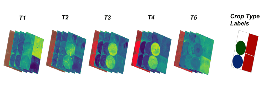
Open Repository for Geospatial Training Data Released
Radiant Earth has launched Radiant MLHub, a cloud-based open library for training geospatial data used by machine learning algorithms.

Satellite Data Shows That Tilling Less Leads to Healthier Soils
Researchers applied machine learning to satellite-derived datasets to to analyze tillage practices and crop yields in the US Corn Belt between 2005 and 2017.

There are Four Trillion Measurements in this Global Sea Surface Temperature Dataset
Researchers have compiled an enormous global dataset with over four trillion satellite-based measurements of sea surface temperature.

Do Bison Influence the Spring Season?
Researchers took a look at the foraging behavior of Yellowstone’s bison (Bison bison) to see how well their grazing behavior fits with the Green Wave Hypothesis.
MERIT Hydro: A High-Resolution Global Hydrography GIS Dataset
Researchers have developed a high-resolution GIS dataset of river systems using remotely sensed data and OpenStreetMap data.

Lowest Natural Point in Japan
At 4 m (13 ft), Lake Hachirō in Akita Prefecture in northern Japan is the lowest natural point in Japan.

Map of Geospatial Companies Around the World
Christoph Rieke has assembled a growing list of commercial geospatial companies with offices located all around the world.