
Articles

How This Remote Island Inhabited by Polar Bears Became Known as Landsat Island
A few unusual pixels in Landsat imagery led to the discovery of a previously unmapped island off the coast of Labrador, Canada.

Kambalny Volcano Erupts for the First Time in Almost 250 Years
While the Kamchatka Peninsula has the highest concentration of active volcanoes on Earth, until recently the Kambalny Volcano had been dormant for almost 250 years.
Sports Geography
Sports, by nature, have location and spatial phenomena that are terrestrial, there are human-environment relationships, and regions have variations with how given sports are played.

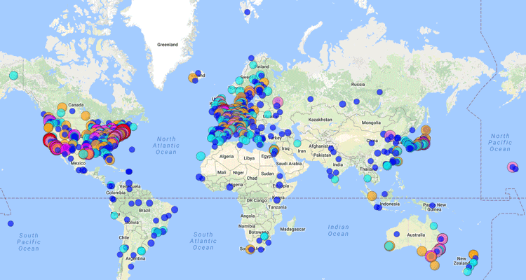
Navigation, GIS, and Voice Command
Progress has been made on developing GIS and GPS technology capable of interpreting natural language and voice commands.

Teaching Context When it Comes to Map Projections
Context is needed in teaching about distortion created by different map projections.

Understanding Ocean Wave Patterns from Satellite Imagery of Sun Glitter
Researchers have developed a method by which to translate satellite imagery of sun glitter on the water into data about the direction, height and movement of waves.

ESA’s Swarm Satellites Reveal Detailed Variations in the Earth’s Magnetic Field
Three years of data collection the European Space Agency's (ESA) Swarm satellites has resulted in the highest resolution map of Earth’s lithospheric magnetic field.

Data Driven: GIS Guiding the Future
Mapping has always been data driven, and the more data we gather, the more important practical visualization of that data becomes.

How 1Spatial is Helping the Arizona Department of Transportation Automate Validation of State-Wide Road Network
Sheila Steffenson discusses how the Arizona Department of Transport will be able to validate and integrate its own road network information with regular updates from multiple contributing government bodies within the state using 1Spatial technology.

Using Terra and Aqua Layers with Open Satellite Map
Georgy Potapov of OpenWeatherMap introduces the availability of low resolution MODIS imagery from Aqua and Terra satellites via the VANE platform.

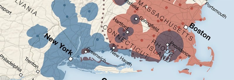
Geography and Family Structure
Factors of geography, economics, and social trends have contributed to diverse ranges of household formation.
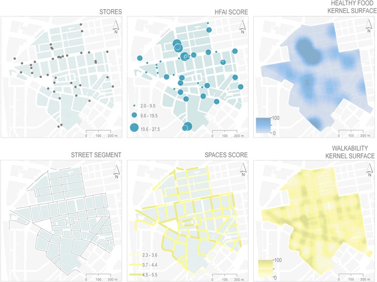
GIS and Obesity
GIS has been used to measure the built environment and its relationship to obesity.

GIS and the Geography of Religion
GIS has become an important historical and contemporary analytical tool used to explain past and current social trends shaping and being shaped by religions.

Color to Your Heart’s Delight With These Historical Map Coloring Pages
Relax and reduce your stress by printing out and coloring in these maps.
Parts of the World That Cartographers Keep Forgetting Exist
Some places and countries seem to be frequently left off of maps because cartographers keep forgetting they exist.

Sign Language on Maps
The Atlantic Provinces Sign Language Place Names map is an interactive map with place names described in American Sign Language, commonly used across the United States and Canada, as well as a regional dialect known as Maritime Sign Language.
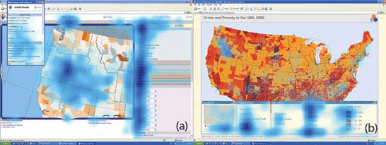
Analyzing Eye Movement For Better Map Design
With new and growing areas where eye monitoring and GIS can be utilized together, big data techniques will be a leading way in which visual and analytical understanding of spatial cognition will be understood in coming years.
Geography of Science
Despite the role of the Internet in allowing greater global connectivity, local geography still plays a dominant role in shaping science.

Using Visual Search to Find Geographically Similar Features on Satellite Imagery
Descartes Labs recently unveiled its GeoVisual Search application which uses machine learning to visually search satellite imagery for similar geographic features.

Geography and the Law
Law geographers have advanced the understanding that law also requires knowledge of geographic and other factors that may intersect in how law is developed and applied.

Tracking Deforestation by Measuring the Distance to the Nearest Forest
Using satellite images, researchers established a method of calculating the distance between any point in the continental United States and the nearest forested area.

The Need For Ethics in GIS
The consideration of a code of ethics in GIS has mostly been overlooked as a critical component in geospatial education and certification.

3.1-Trillion Pixel Landsat 8 Mosaic of the World
Descartes Labs has compiled some of the massive amount of data sent back from the satellites orbiting Earth into a 3.1-trillion pixel composite image of Earth’s surface.

Zealandia: the World’s 8th Continent
As it turns out, we might have one more continent to add to Earth’s collection. The continent, dubbed Zealandia, is composed of nearly 5 million square kilometers of land including New Zealand and New Caledonia and is mostly underwater.

Geography of Global 500 Companies in 2016
Find out which countries, cities and US states have the most Global 500 countries in 2016.

View the Human Footprint on this Rotating Globe
View the global human footprint map developed from 180,000 satellite images.