
Articles
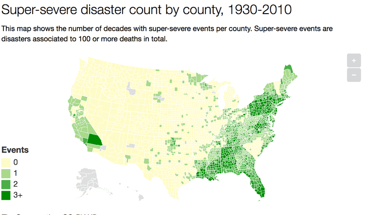
A Look at 90 Years of Natural Disasters by County in the United States
Researchers have mapped out ninety years of natural disasters data by county in the United States.

Using Satellites to Monitor Terrestrial Gamma Ray Flashes
The production of gamma rays that can be seen by satellites are called terrestrial gamma ray flashes, or TGFs.

GIS and Advertising
Advertisers are becoming more sophisticated with the use of GIS as a way to better target their audiences.

Mapping Urban Vacancy
Nicholas de Monchaux, an urban design professor at UC Berkeley, has designed a project called Local Code that maps the underused sites in a city’s infrastructure and analyses how these spaces could be used to improve the local ecology.

Automated Generalization Sped Up Cartographic Output by 40% for This German Mapping Agency
Working with 1Spatial, AdV’s ATKIS-Gen Project Group's cartographic output is 40% faster with automated generalization.

Adonis: Europe’s Oldest Known Living Tree
A 1,075-year old pine tree known as Adonis is believed to be the oldest tree in Europe.

Great Elephant Census
The group called Elephants Without Borders has recently finished a two-year survey of African elephants across the entire continent, known as the Great Elephant Census (GEC).

Be Aware of the Proposed Geospatial Data Act (GDA) of 2017
The Geospatial Data Act (GDA) of 2017 is being reintroduced in Congress. Passage of this bill would have a severe impact on the GIS industry.

Using Free and Open Source GIS to Support Natural Resource Management in the Developing World
Rohan Fisher describes his GIS work for decentralized, evidence-based resource management in developing nations.

Find Ocean Features with this Directory
The GEBCO Undersea Features Gazetteer lets users find information about ocean features.
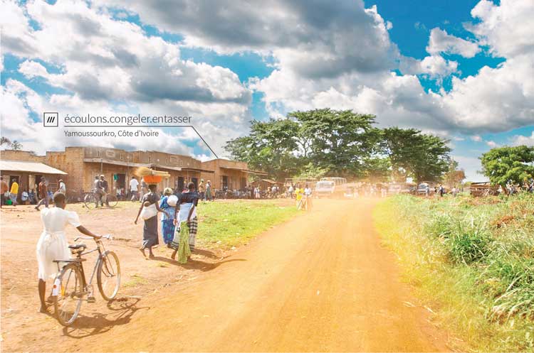
How Three Random Words are Helping with Global Mail Delivery
What3Words has come up with a way of accurately delivering mail even in locations where street addresses don't exist.
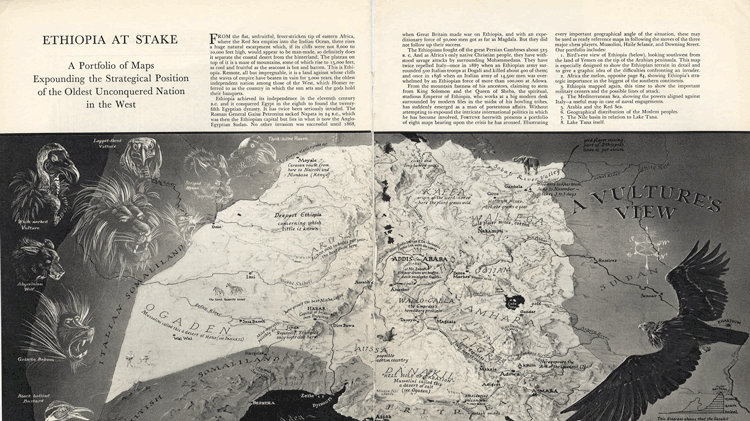
Persuasive Cartography: How Maps are Used to Shape Our Beliefs
Persuasive cartography involves making maps that attempt to shape our beliefs.

This Globe Unfolds Like an Umbrella
John Betts's 15 inch (37.5 cm) diameter collapsible globe expanded much like the mechanism by which an umbrella unfolds.

Geography of the Film Industry
Human geographers have studied how the film industry has developed in different countries and regions within countries.

Mapping Rainforest Chemistry
Researchers mapped 23 chemicals that are released by the rainforests in Peru with laser-guided imaging spectroscopy.

WMS Map Viewer
WMS Map Viewer, developed by Pantelis Rodis, is a http/JavaScript application for visualizing, combining and indexing web maps.

Visualizing the Impact of Gentrification
Graphic designer Herwig Scherabon has developed a book visualizing the impacts of gentrification in a number of cities in the United States and United Kingdom. Combining public access data and research with crisp visuals, Scherabon illustrates the spatial distribution of gentrification and examines the different issues at play.

GIS and Flight Training
The future of aviation technology looks to continue to utilize GIS in ways that allow better training and smarter aircraft.

Medieval Irish and Colorful Winds
Medieval Ireland attributed a different color for each of the cardinal and ordinal directions of the wind.
Review | Worlds Fantastic, Worlds Familiar: A Guided Tour of the Solar System
G.T. Dempsey reviews Bonnie J. Buratti's Worlds Fantastic, Worlds Familiar: A Guided Tour of the Solar System.

How Geography is Used to Study Agriculture
From climate to key trade and shipping hubs, geography has shaped the fortunes of states and agricultural production.

The Use of Python in GIS
Python today is by far the most widely used language by GIS users and programmers.

Streamline GIS Project Workflow with Online Recordkeeping
For efficient collaboration on a GIS project, document and catalog all work in an easily accessible location to overcome common challenges with diverse skill sets.

A New Algorithm to Find Wildfires When It’s Cloudy
New technology called the Firelight Detection Algorithm, or FILDA, can help detect wildfires at night even when the skies are cloudy.

Defining Urban Sprawl
The urban sprawl concept caused researchers to dive into figuring out what city in the world is the biggest based on the size of its urban sprawl.

Mapping Urban Trees and Income in Manhattan
This article analyzes tree and income data for the New York City borough of Manhattan.