
Articles

How to Find the Latitude and Longitude of a Location Using Google Maps
This tutorial will take you step-by-step through the process of finding the X,Y coordinates of a specific location using Google Maps.

Digital Hegemony: How Local Your Google Search Results are Depends on the Country
Researchers took at look at search results on Google for 188 capital cities to see the country of origin for the top results.

Review | Curbing Catastrophe: Natural Hazards and Risk Reduction in the Modern World
G.T Dempsey reviews Timothy H. Dixon's new book, 'Curbing Catastrophe: Natural Hazards and Risk Reduction in the Modern World.'
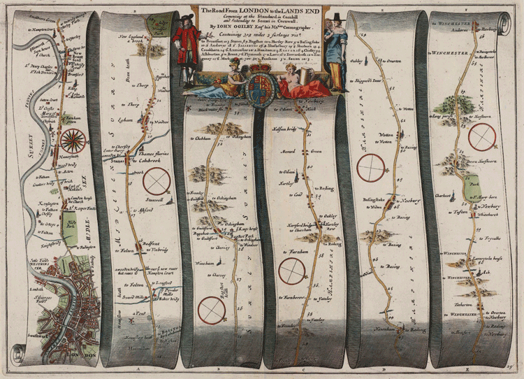
Early Data Visualization Pioneers
RJ Andrews created DataViz based on his collected notes to provide readers with insight into five of the earlier pioneers of data visualization.

GIS and Spatial Autocorrelation
Spatial autocorrelation statistics have become incorporated into commonly used packages such as ArcGIS as well as open source software such as GRASS and QGIS.
Sub-surface Mapping and Subterranean Data Representation
ArcGIS Online advances sub-surface mapping with 3D options, enhancing design, accessibility, and customization for urban planning and transportation.

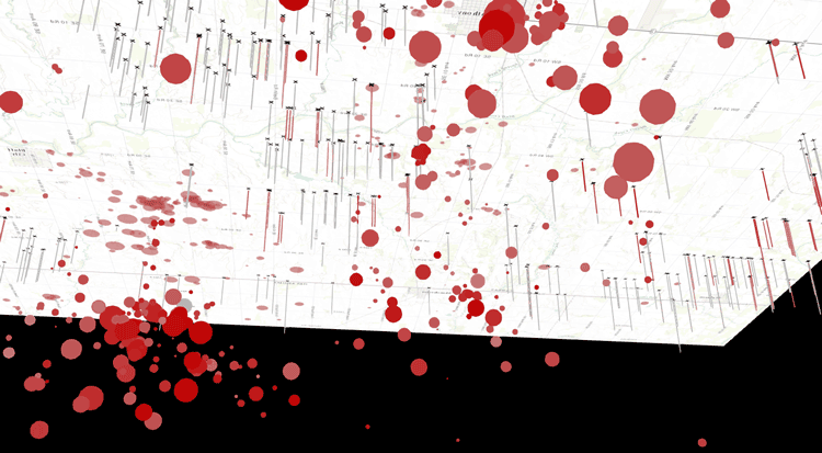
Detecting Spatial Patterns in Drug Abuse With GIS
Drug abuse has been shown to have clear spatial patterns that GIS has helped to demonstrate.

How Agencies Can Harness Geosharing to Improve Infrastructure
How can communities become more engaged with reporting issues with infrastructure? Olivia Harne discusses how an investment in geographical data sharing could be a potential solution.

Creating and Editing Features with MapInfo
This tutorial by Nick Williams, a MapInfo trainer at Acuity Training, provides an overview of how to create, edit, and convert features within MapInfo.

GIS RoadMap and Mobile Strategy for Engaging Missouri Constituents
Douglas Fees, the Information Technology Services Chief with the Missouri Department of Conservation (MDC) discusses how his agency collaborated with Timmons Group to develop a GIS roadmap and mobile strategy that resulted in a suite of applications to better serve citizens, visitors and internal MDC staff.

Global Landslide Susceptibility Map Highlights Overlooked Regions of the World
NASA satellites and imagery can detect where in the world landslides are likely to occur based on geographical features and the amount of precipitation that has fallen in the area.
GIS and Topic Modeling
Topic modeling is a thriving field in humanities and social sciences, with GIS being use to identify trends in social media.
Using Geolocation to Connect Geography with Genealogy
The ability to create a potential geographic scrapbook could add a new dimension to the popularity of genealogical research.
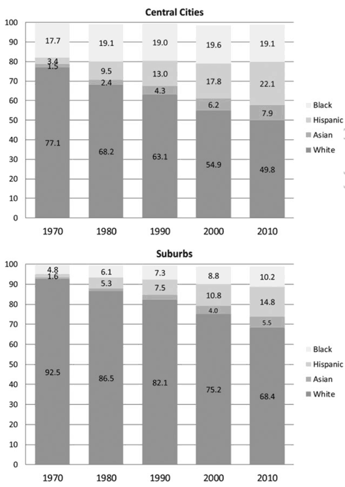
Racial Diversity Still Lacking in US Suburbs Per Study
A study out of Princeton University has found that United States suburbs are still mostly dominated by white residents.
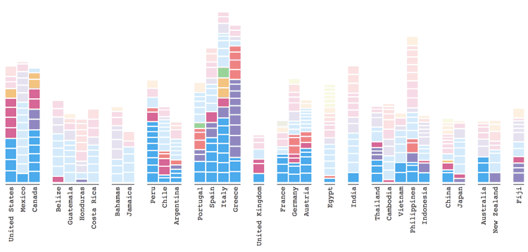
Geography of Google Search
Explore Adventure analyzes where and when people in different countries search for locations in other countries.

How the ‘Quirky Geography’ of ZIP Codes Obscured Flint’s Lead Problem
Richard Casey Sadler, an assistant professor at Michigan State University discusses how the Michigan Department of Health and Human Services' reliance on using ZIP Code level data obscured the link between Flint residents and lead exposure.

Online Atlas Tracks Ecologically Troubled Areas of the World
A new atlas produced by Richard Weller from the University of Pennsylvania tracks how urban sprawl and human activities are endangering bioregions on Earth.

Geography and Segregation
Socio-economic classes, ethnic groups, and race are some of the main factors that affect the geography of segregated populations.
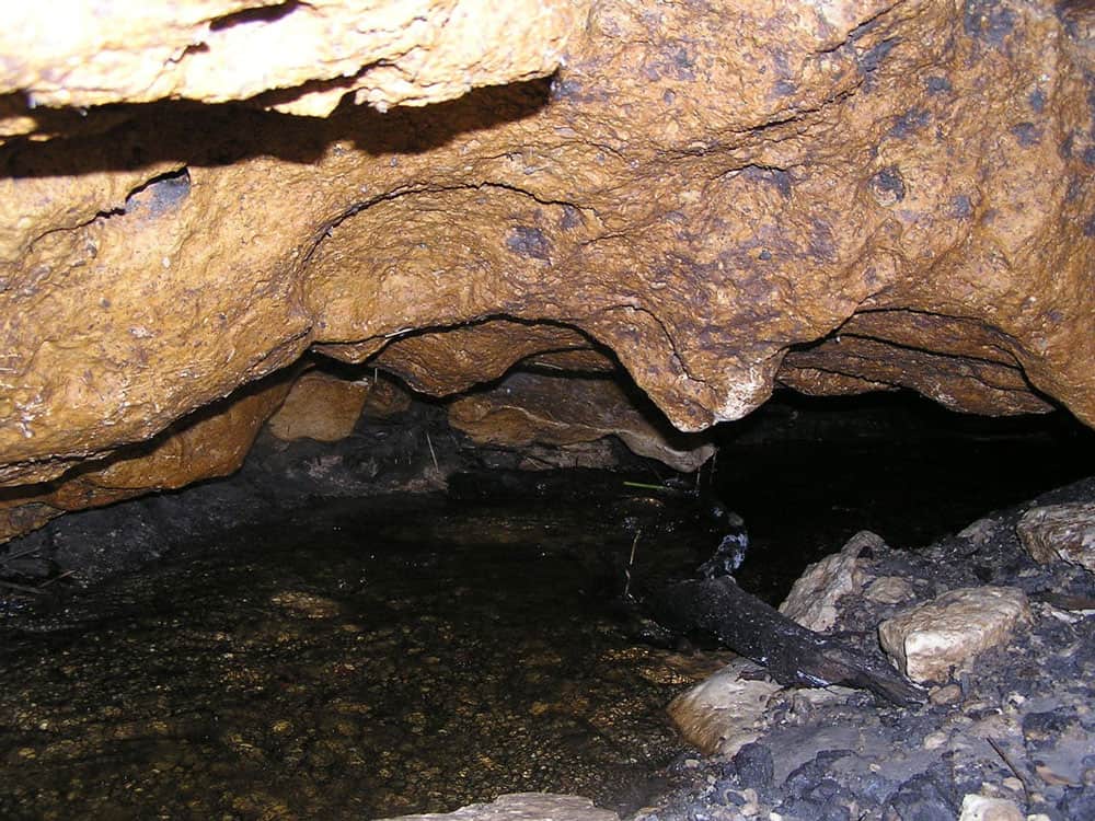
GIS and Karstic Cave Monitoring
GIS and remote sensing have been used to predict likely regions where caves can be found.

Using GIS to Conserve the Greater Sage-Grouse
GIS has emerged as an essential analysis and communication tool for the Oregon BLM in general, and its sage-grouse conservation efforts.

Monitoring Livestock Using GIS
GIS and other geospatial technologies are being used to monitor livestock, understand the role that cattle play in climate change, and estimate biofuel.

Understanding What Six GIS/Map Software Providers Offer
Matt Sheehan from WebMapSolutions is posing a series of six questions to six GIS/map software companies (Pitney Bowes, Esri, Mapbox, Carto, GIS Cloud, and Boundless) to understand their similarities and differences in product offerings.

World’s Longest Piers
Learn about the world's largest disembarkation pier, wooden pier, and pleasure pier.

Create Custom Map Projections
Flex Projector is a free and open source, platform agnostic software application that lets users upload GIS data and create customized small scale global map projections.

A Global Landslide Potential Map That Updates Every 30 Minutes
Researchers from NASA have developed a global landslide susceptibility model that maps out areas in danger of potential landslides every thirty minutes.

Seven Words to Know About Squirrels
Here are seven words anyone who loves to learn about squirrels should know.