
Articles

Mercury Levels Greatest Among Marine Birds in Western North America
A research study has identify areas in North America that are hotspots affecting mercury blood levels in birds.
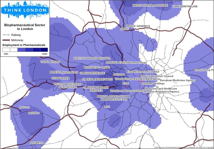
GIS and Entrepreneurs
GIS aids in investment decision-making by unveiling spatial patterns key to entrepreneurial success like labor concentration, knowledge, and opportunities.
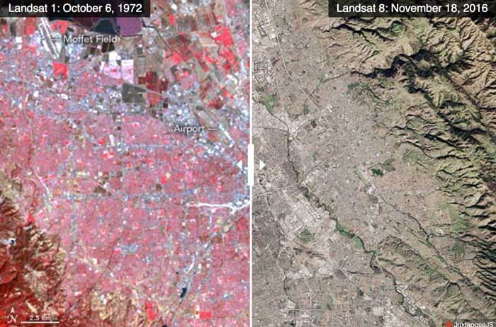
Advances in Landsat Sensors
Since those first images in 1972, multiple Landsat satellites have been launched with the ability to take increasingly detailed pictures of our world.

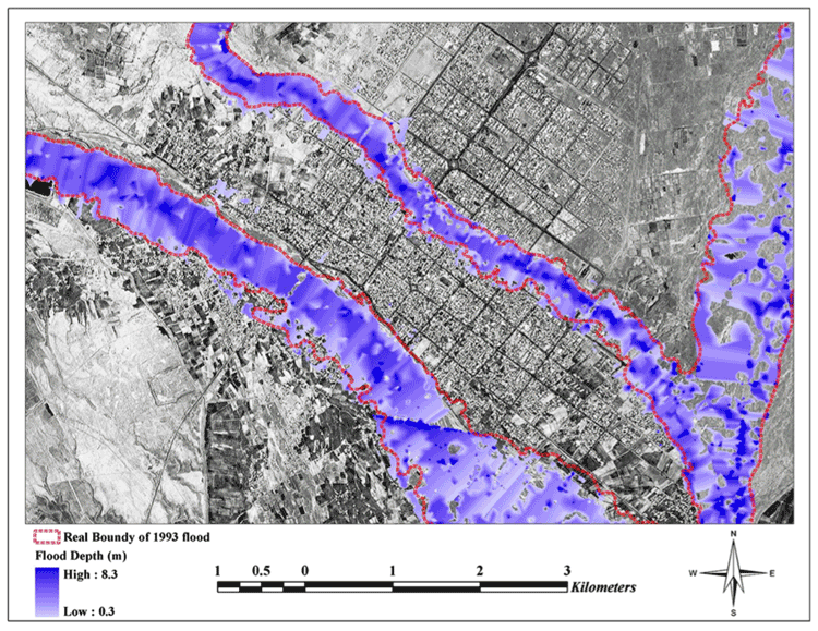
Restoring a Salt Marsh
The San Francisco Bay was once connected to a large salt marsh that contained many different and rare species of plants and animals. Conservationists are now restoring the salt marsh.

These US Towns Each Have Less Than 15 Residents
Here are a few smaller than small towns in the United States.

How GIS Can Help With Football Game Analysis
Football, or Soccer, is a spatial strategy game involving tactical player movements, which can be analyzed effectively using Geographic Information Systems (GIS).

How to Create a Non-contiguous Cartogram Using QGIS
This article presents a rough idea of how one might mimic a non-contiguous cartogram using QGIS.

Creating Non-contiguous Cartograms
Non-contiguous cartograms are a type of area cartogram. In a non-contiguous cartogram, the features are not connected and enlarge or shrink based on a quantified value.

Mapping Urban Trees Using Google Street View imagery
A project by the MIT Senseable City Lab, dubbed Treepedia, has mapped the amount of trees that were growing in major urban areas.

Celebrating Valentine’s Day, Geographer Style
What better way for geographers to say "Happy Valentine's Day" than with geography? Nature supplies us with plenty of heart shape topography found around the world. Heart shaped islands, vegetation, and lakes make up this love themed geography article.
Red Sprites and Blue Jets: Electrical Storms in the Upper Atmosphere
Known as red sprites and blue jets, these electrical storms shoot lightening up into space towards the outer edges of Earth's atmosphere instead of towards the surface of the Earth.
How GIS Helps with Researching Human Evolution
GIS has now provided new avenues of research that has helped physical anthropologists better understand how different hominid species evolve to different environments.

These Extremophiles Produce Brilliant Colors
An extremophile is an organism that can live in extreme physical or geochemical conditions.

Using Green Space to Reduce Water Pollution
Researchers have used satellite data to analyze images for areas that should be protected as green spaces which in turn help protect Atlanta’s water supply.

Study Examines Trends in Global Warming
A multi-institutional study has recently come out with new research that studied the temporary slowdown of rising temperatures around the Earth.
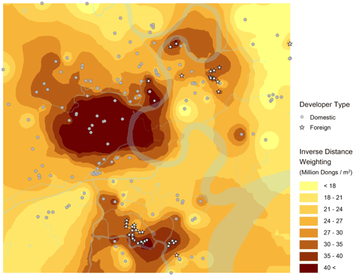
Utilizing GIS for Investment Opportunities
GIS-based spatial understanding can crucially inform where and how to invest in specific markets.

Geography and Paleoclimate
Paleoclimate has had a major effect in shaping not only physical geography but also biodiversity in different parts of the Earth.
Using GIS in the Insurance Industry
Location has a large impact for the insurance industry, as a variety of natural or even social risks, such as crime, could affect insurance rates for life and property.
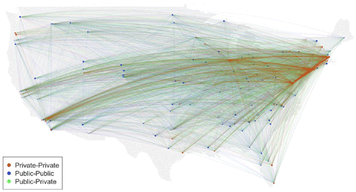
Using GIS to Analyze the Death of Distance Hypothesis
Recent studies using GIS show that geographic factors continue to play a strong role in regulating social, economic, and general Internet use despite technologies that was purported to mitigate the effect of distance.

Finding Love Using GIS
The omnipresence of location, GIS functionality in mapping, and measuring potential dates near you, has had a substantial social change in the dating world.

This Map Shows That By 1907, Only 11 Car Trips Across the United States Had Been Made
In 1907, a three-volume publication of the Blue Book included a map showing the 11 recorded transcontinental trips that had been made to date.

Polar Bears Can Be Found in Which Countries?
Learn about which countries contain the habitat range of the polar bear as well as a map of the polar bear habitat.

The History of Mapping Disease
Cartographies of Disease: Maps, Mapping, and Medicine takes a look at how cartography and GIS have been used to map and combat devastating diseases such as cholera, yellow fever, and Ebola.

MapInfo Resources
Here are some suggestions for peer support and resources offered for users of MapInfo.

Habitat Fragmentation: A Multi-Scale Approach detailing its lasting impact on Earth’s ecosystems
An analysis performed at multiple spatial and temporal scales argues that destruction and degradation of natural ecosystems are the primary cause of global declines in biodiversity.

Open Data Program Launched by DigitalGlobe
The Open Data program offers high-resolution satellite imagery and crowdsourced GIS layers for large-scale natural disasters.