
Articles

Where are the Desolation Islands?
Located in the southern Indian Ocean off the eastern coast of Africa and just north of Antarctica, the Kerguelen Islands have earned the nickname "Desolation Islands" due to their remote location.

What are the Three Plates that Make up the Mendocino Triple Junction?
The Mendocino Triple Junction is located in the Pacific Ocean near Cape Mendocino in northern California.

Analyzing Risk for Radioactive Materials Using GIS
Earlier GIS studies focused on analyzing safe routes for transporting radioactive materials, while recent ones have quantified the storage risk.

Match Scribbles to Features on the Earth
Land Lines is an experimental online tool that matches drawn gestures on the screen with landforms extracted from satellite imagery.

Test Your Topsy Turvy Geography Smarts with this Map Skills Game
‘Up Side Down’, tests your map acumen by either zooming in to a tilted location that you have to identify or placed disparate features together and quizzes you on which one is the answer to the question.

Seven Intriguing Maps from 2016
Here is a handpicked selection of seven of the most intriguing maps published online and in print in 2016.

3 Ways to Send a Geo Season’s Greetings
Here are three ways you can pass along your end of the year cheer to geography enthusiasts no matter where they live.

How the Commutes of 130 Million Commuters Reveals Megaregions in the United States
A study using data from 130 million commuters has revealed commuter-driven megaregions in the United States.

7 Geography Books to Add to Your Bookshelf
Listed here are seven intriguing books about geography that are a great addition to any geographer's collection.

Using Census Data to Define US Commuter “Megaregions”
Researchers analyzed Census data to map out commuter megaregions in the United States.
![Meandering river in Nyingchi, Tibet, China [view in Timelapse] (Image credit: Landsat / Copernicus*). Via: Google](https://www.geographyrealm.com/wp-content/uploads/2020/08/Timelapse-Tibet_China.gif)
Update Google Earth Time Lapse
Google Earth has released a new time-lapse of the Earth, composed of over 5,000,000 satellite images.
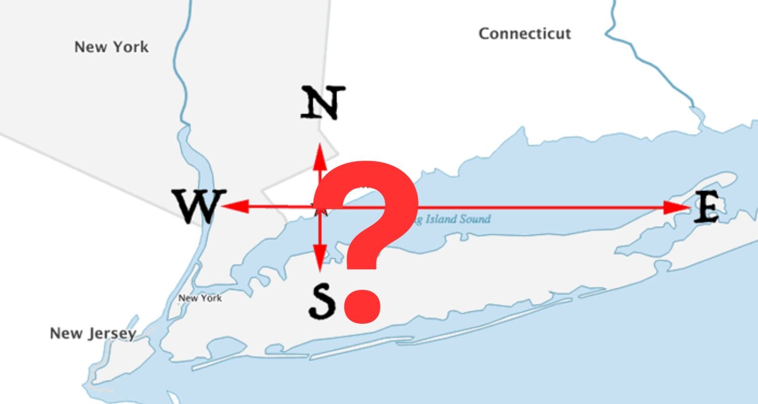
From Which U.S. City Can You Travel North, South, East, or West and End up in the Same State?
Can you answer this geography riddle? From which United States city can you travel due north, south, east, or west and still enter the same bordering state?
7 Fun Stocking Stuffer Gifts for Geographers
Looking for items for your favorite geographer's Christmas stocking? The items on this list make perfect gifts for the geogeek in your life for gift exchanges with small budgets.

7 Nifty Gift Ideas for the GIS Person in Your Life
Whether you are looking for gifts for Christmas, Hanukah, Kwanzaa, Festivus, or just looking for a special gift for any time of the year, here are some gift ideas for a range of budgets. From silly to serious, find the perfect GIS gift idea on this list.

NASA Exploring Using Mini-drones
NASA has gotten in on the drone action themselves, testing unique mini-drones that are manufactured in Sweden.

What are Qanats?
Qanat are underground water channels developed during ancient times to carry water using gravity via a gentle downward slope.

First Data Released From ESA Satellite Sentinel 3-A
The European Space Agency and Eumetsat have just released the first data from their new satellite platform, Sentinel 3-A. This groundbreaking new Earth observation platform can monitor a wide range of Earth systems, and will play a vital role in understanding our planet into the future.

Geography and Inequality
Simple examples of geographic social inequality can be found in major cities, where wealthier urban people generally have access to more housing, food shops, basic amenities, healthcare, and other infrastructure than the urban poor.
How Geography Influences Voting Behavior
Voter turnout in elections is heavily influenced by factors such as geographic proximity to polling places. Voter turnout is influenced by a variety of factors, including race, district size, district redrawing, and even weather.

Geography of Conflict
Geography can show us how physical and social factors shape global conflict today and in the past.


3D Print Your Own Universe
Researchers have created a way for people to 3D print their own tiny universes using physics and modern technology.

Using GIS in Landscape Archaeology
Landscape archaeology is a discipline where space is critical to understanding ancient settlements and human use of ancient space. The use of GIS is steadily growing as a tool in this field.

Landsat 9 Will Launch in 2020
The Landsat series of satellites has been imaging the Earth’s surface for nearly 50 years, providing vital imagery for a range of purposes from the natural sciences to civil administration and conflict monitoring. NASA and the USGS recently announced that the next iteration of the program, Landsat 9, is due to launch in 2020.

Spot the International Space Station Using this Map
Even if you can’t reliably see the night sky, you can track the movement of the International Space Station with NASA’s Spot the Station interactive map.

Is this the Most Accurate Worldwide Map Projection?
This new map, called the AuthaGraph, may be the most accurate map projection created to date.