
GIS and Geospatial Technologies
Articles focusing on the application of geographic information systems (GIS), geospatial technologies, remote sensing, LiDAR, and Global Positioning System (GPS). These technologies serve as critical tools for understanding and interacting with our physical environment. GIS allows for the mapping and analysis of spatial data Geospatial technologies refer to the various tools used to measure and analyze Earth’s lands and resources. Remote sensing provides a way to collect data from a distance, often via satellites or high-flying aircraft, and is commonly used for environmental monitoring and military applications.
GIS subcategories :
GIS Career | GIS Data | GIS Industry | GIS Learning | GIS Software | GPS | Remote Sensing | Spatial Analysis
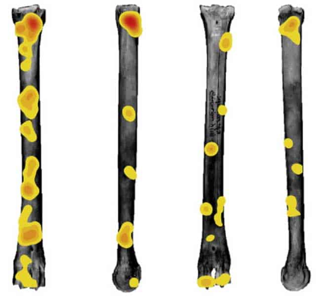
How GIS Helps with Researching Human Evolution
GIS has now provided new avenues of research that has helped physical anthropologists better understand how different hominid species evolve to different environments.
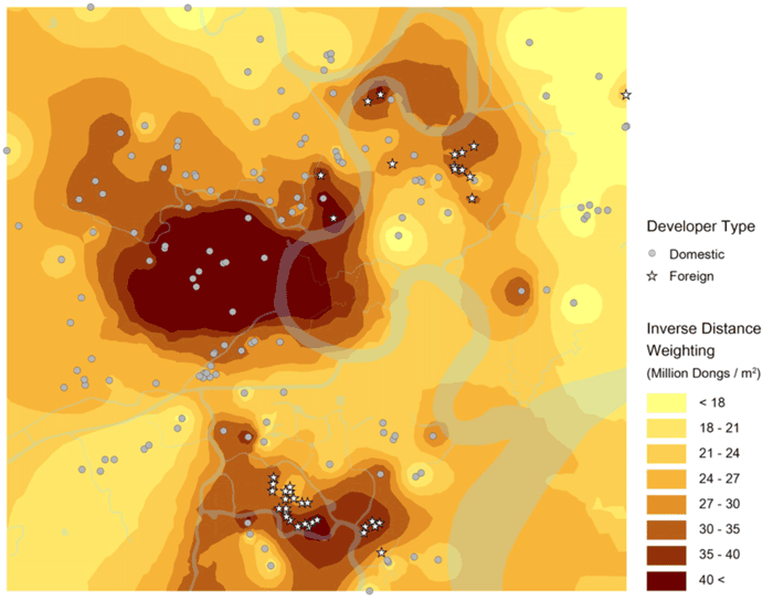
Utilizing GIS for Investment Opportunities
GIS-based spatial understanding can crucially inform where and how to invest in specific markets.
Using GIS in the Insurance Industry
Location has a large impact for the insurance industry, as a variety of natural or even social risks, such as crime, could affect insurance rates for life and property.
Using GIS to Analyze the Death of Distance Hypothesis
Recent studies using GIS show that geographic factors continue to play a strong role in regulating social, economic, and general Internet use despite technologies that was purported to mitigate the effect of distance.

Finding Love Using GIS
The omnipresence of location, GIS functionality in mapping, and measuring potential dates near you, has had a substantial social change in the dating world.

The History of Mapping Disease
Cartographies of Disease: Maps, Mapping, and Medicine takes a look at how cartography and GIS have been used to map and combat devastating diseases such as cholera, yellow fever, and Ebola.

MapInfo Resources
Here are some suggestions for peer support and resources offered for users of MapInfo.

Open Data Program Launched by DigitalGlobe
The Open Data program offers high-resolution satellite imagery and crowdsourced GIS layers for large-scale natural disasters.
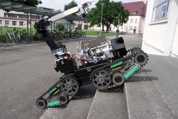
How Robots Can Help Improve GIS Data
Robotic platforms are actively used to collect spatial data, including GPS data, to help map floor plans and wider areas.

Mapping Billions of Data Points in Milliseconds
With its GPU power, MapD can process and map billions of data points in milliseconds.

Helping Chimpanzee Conservation Efforts with Satellite Imagery
NASA has partnered with the Jane Goodall Institute to provide satellite imagery and the analysis needed to understand where habitat loss is the most extreme to protect chimpanzees in the wild.

Learn How to Access and Use Sentinel-3 Data
Learn how to download and use earth observation data from ESA's Sentinel-3 satellite.

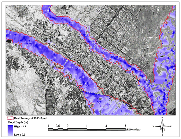
Three Examples of Geospatial Innovation in Emergencies
Bailey Morton outlines three examples of how innovative geospatial analysis can help save lives in emergency situations.
Using GIS to Study Plant Behavior
The application of plant biology with GIS has potentially important implications for the study of plant behavior affecting important factors such as the Earth’s climate and agricultural supplies.

Using Machine Learning and Satellite Imagery to Estimate Corn Crop Production
Descartes Lab, a start-up organization, has created crop production analysis that uses millions of satellite images and machine learning to produce accurate data about the production of agricultural crops.

VANE Query Language: Intuitive Access to Satellite Imagery
Georgy Potapov of OpenWeatherMap introduces the release of the VANE language service, an entirely online service that presents a new concept for accessing satellite imagery. Potapov shares OpenWeatherMap’s vision of how developers can work with satellite and weather data to help the overall geoinformation market to grow.

Find Users of Open GIS Data from Around the World Thanks to the Center for Open Data Enterprise
The Center for Open Data Enterprise is working to improve the quality of open access data worldwide, including GIS data sources.

Using R with GIS Software
With the utility of R, many popular statistical procedures and more advanced analyses, including a variety of simulation applications, can be applied directly within GIS tools such as QGIS.

Using GIS to Assess and Mitigate Rail Hazards
GIS has been of interest to rail companies, NGOs, and governments attempting to minimize a variety of hazards that may affect the rail network.

GIS and Semantics: Enabling the Discoverability of Data
Much like the semantic web, methods exist in GIS to streamline the search of diverse geospatial data through certain protocols and standards.
Harness the Power of Open Source GIS with a Hybrid Architecture
Anthony Calamito, Chief Evangelist at open source GIS company, Boundless, explores how companies can harness the power of their open source GIS systems.

Analyzing Risk for Radioactive Materials Using GIS
Earlier GIS studies focused on analyzing safe routes for transporting radioactive materials, while recent ones have quantified the storage risk.

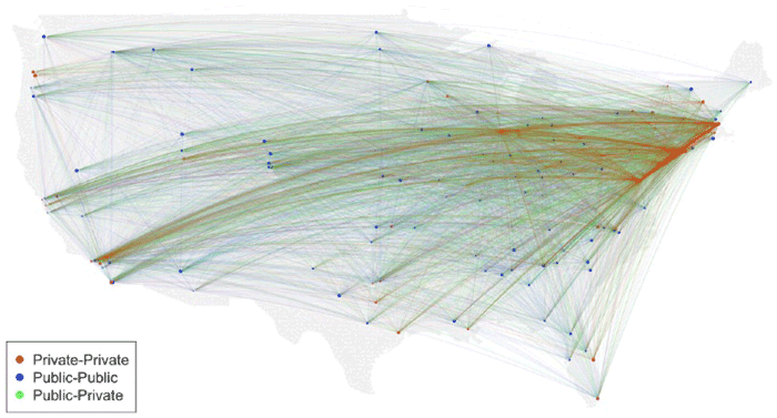
Using Census Data to Define US Commuter “Megaregions”
Researchers analyzed Census data to map out commuter megaregions in the United States.
![Meandering river in Nyingchi, Tibet, China [view in Timelapse] (Image credit: Landsat / Copernicus*). Via: Google](https://www.geographyrealm.com/wp-content/uploads/2020/08/Timelapse-Tibet_China.gif)
Update Google Earth Time Lapse
Google Earth has released a new time-lapse of the Earth, composed of over 5,000,000 satellite images.

NASA Exploring Using Mini-drones
NASA has gotten in on the drone action themselves, testing unique mini-drones that are manufactured in Sweden.

First Data Released From ESA Satellite Sentinel 3-A
The European Space Agency and Eumetsat have just released the first data from their new satellite platform, Sentinel 3-A. This groundbreaking new Earth observation platform can monitor a wide range of Earth systems, and will play a vital role in understanding our planet into the future.