
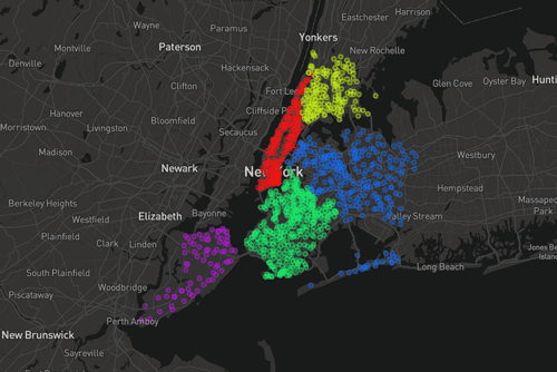
GIS and Geospatial Technologies
Articles focusing on the application of geographic information systems (GIS), geospatial technologies, remote sensing, LiDAR, and Global Positioning System (GPS). These technologies serve as critical tools for understanding and interacting with our physical environment. GIS allows for the mapping and analysis of spatial data Geospatial technologies refer to the various tools used to measure and analyze Earth’s lands and resources. Remote sensing provides a way to collect data from a distance, often via satellites or high-flying aircraft, and is commonly used for environmental monitoring and military applications.
GIS subcategories :
GIS Career | GIS Data | GIS Industry | GIS Learning | GIS Software | GPS | Remote Sensing | Spatial Analysis


Using GIS in Landscape Archaeology
Landscape archaeology is a discipline where space is critical to understanding ancient settlements and human use of ancient space. The use of GIS is steadily growing as a tool in this field.

Landsat 9 Will Launch in 2020
The Landsat series of satellites has been imaging the Earth’s surface for nearly 50 years, providing vital imagery for a range of purposes from the natural sciences to civil administration and conflict monitoring. NASA and the USGS recently announced that the next iteration of the program, Landsat 9, is due to launch in 2020.

Using GIS to Understand Species Evolution
Studies have used spatial modeling and GIS approaches to understanding species evolution.

Using UAVs to Map and Monitor Pipelines
Unmanned Aerial Vehicles (UAVs) are currently being used to not only speed up the pipeline routing process but also to make it both safer and more economical.

GIS and Innovations in Machine Learning
Machine learning or artificial techniques has been rapidly transforming many areas related to GIS and spatial applications

Using Remote Sensing to Understand the Correlation Between Deforestation and Forest Fires
MAAP has used remote sensing to discover a correlation between deforestation and forest fires in Tampbopata, Peru.

GIS and Social Activism
Groups promoting various causes are implementing geospatial approaches and GIS related technologies.

How Spatial Modeling Can Help with Refugee Aid
GIS is being used to address the spatial problem of allocating resources and constructing refugee camps.

Making 3D Models with Photogrammetry
With the prevalence of smartphones and drones, photogrammetry is now widely present as an effective and cost-efficient method to easily recreate 3D models of large areas and specific objects or buildings.

How GIS Can Help Dentists Find Cavities
GIS is making inroads in dentistry, where dentists now use spatial technologies for diagnosis and dental surgery.

Mini Satellite Constellation to Explore the Outer Reaches of Our Atmosphere
An international scientific project is conducting an unprecedented study of the atmosphere’s outermost layer. Fifty tiny satellites will measure the attributes of the thermosphere, a poorly understood but vitally important region.

How GIS is Helping Gardening
GIS is used in gardening to manage and comprehend the spatial layout of plants, from research and public gardens to home and backyard settings.

Using GIS in Space Exploration
While we generally think of GIS applied to objects or systems on Earth, GIS has been of great utility for space exploration.

Collecting GIS Data with Drones
Drones are rapidly being adopted as a way to quickly collect aerial imagery and other forms of geospatial data.

Integrating Spatiotemporal Data with Terra Populous
Terra Populus is a project designed to combine data sets and geographic information to facilitate finding and extracting data for research.
How To Make a Map From Open Data Using a Spreadsheet
Jonathan Goldman explains in this tutorial how to extract an open data feed from a civic data portal and pull it into Google Sheets, and then map it quickly using Geosheets.

Mapping Market Reach
Troy Lambert discusses how colleges can use GIS and mapping technology to better target marketing.
Using Machine Learning to Map Poverty from Satellite Imagery
Satellite images are now being used to map poverty levels around the world using machine learning used to analyze specific poverty data using a convolutional neural network.

Using GIS to Map Telecommunications
Mapping telecommunication networks is of great importance to both urban and rural regions, particularly as telecommunication networks become even more vital for our daily lives. Terrain, vegetation, urban regions, and other potential interference are often assessed together and GIS tools such as ArcGIS have developed into an industry standard for forecasting cellular tower locations.
Connecting to GPS in Tunnels
Waze is testing out technology it calls "Waze Beacons" to keep drivers connected to GPS navigation systems in tunnels.

GIS and Sustainable Energy
GIS has become a critical planning and management tool for addressing where and how to enable sustainable energy efforts.

GIS and Anti-Crime Measures
This article takes a look at methods which demonstrate the wide and growing field of crime prevention utilizing spatial and GIS approaches.

A Look at KML, an Open Standard to Represent and Visualize Spatial Information
Yang Zhang, associate professor, and Matthew W. McBroom, professor, with Stephen F. Austin State University, provide a brief systematic introduction to KML (Keyhole Markup Language) files.
Teaching GIS in Elementary School
Research on how to best implement GIS education for K-12 has looked at the use of web-based GIS and data that is understandable at different levels.
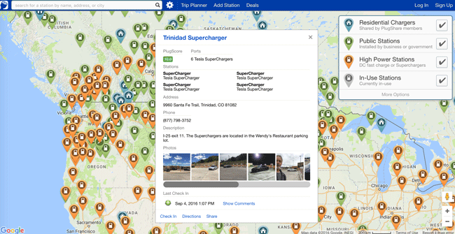
How GIS is Helping Electric Cars on the Road
GIS is playing an important role by helping drivers plan travel that factors in charging stations.