
GIS and Geospatial Technologies
Articles focusing on the application of geographic information systems (GIS), geospatial technologies, remote sensing, LiDAR, and Global Positioning System (GPS). These technologies serve as critical tools for understanding and interacting with our physical environment. GIS allows for the mapping and analysis of spatial data Geospatial technologies refer to the various tools used to measure and analyze Earth’s lands and resources. Remote sensing provides a way to collect data from a distance, often via satellites or high-flying aircraft, and is commonly used for environmental monitoring and military applications.
GIS subcategories :
GIS Career | GIS Data | GIS Industry | GIS Learning | GIS Software | GPS | Remote Sensing | Spatial Analysis

GIS, Pollution, and Health
GIS has been used to assist in showing strong or weak links for given health conditions to different types of pollutants.

GIS and Visualizing Atmospheric Science Data
The use of new data models has allowed more traditional GIS data models to be integrated with those used in atmospheric science.

How GIS Helps Small Ships Navigate
GIS has been utilized in sailing and other small craft to help navigate not just the location of other vessels but also land features and obstacles that may arise or even cause danger to boats.

Improving Satellite Navigation in the Far North
There is currently an effort to extend satellite navigation abilities into the north polar regions for transportation that occurs on land, over the water, and in the air.

Using Satellite Data to Calculate Groundwater
A computer algorithm has been developed at Stanford University that allows researchers to determine groundwater levels using satellite imagery.

View Landsat 8 Imagery With This Free Tool
Users can search, view, and access Landsat 8 imagery with this free online web viewer developed by EOS Data Analytics.

How GIS Helps Drive Hydrography Data
There are more high resolution maps of the Moon and Mars, than the seafloor.

GIS, Elections, and Politics
Political geography focuses on past election cycles in order to look at how voting patterns develop and why. Mark Altaweel discusses how GIS can be used to study those patterns.

Using Remote Sensing to Automate the Detection of Landslides
The Sudden Landslide Identification Product (SLIP) developed by NASA detects landslide potential by analyzing satellite imagery for changes in soil moisture, muddiness, and other surface features.

Use of Earth Observation Data for Oil and Gas
Andrew Cutts, owner of ACGeospatial, discusses the role of GIS and earth observation data in the oil and gas industry in this guest article.

GIS and Quick Response Codes
As smart phones and Quick Response Codes (QR codes) have become ubiquitous, it perhaps should not be surprising we are beginning to see applications integrating QR code data with GIS.

Using GIS to Map Drug Trafficking
GIS has significantly aided police in crime prevention, notably in fighting drug trafficking.

FAO Uses GIS to Protect Agricultural Economy of Vulnerable Countries
Lucia Moro, with the Food and Agriculture Organization (FAO) Geospatial of the United Nations, discusses the agency's work on the development of a global land cover database to support agricultural policy makers and rural land use planners efforts to reduce poverty.
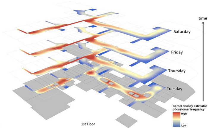
GIS and Small Business Planning
Small businesses increasingly use GIS for spatial analyses like kernel density estimation or Monte Carlo simulation to boost their success.

Using the TravelTime Search API to Generate an Isochrone
This step-by-step guide developed by staff at TravelTime shows how to draw a travel time polygon, filter points of interest by travel time and deliver A to B routing information all in one API call.
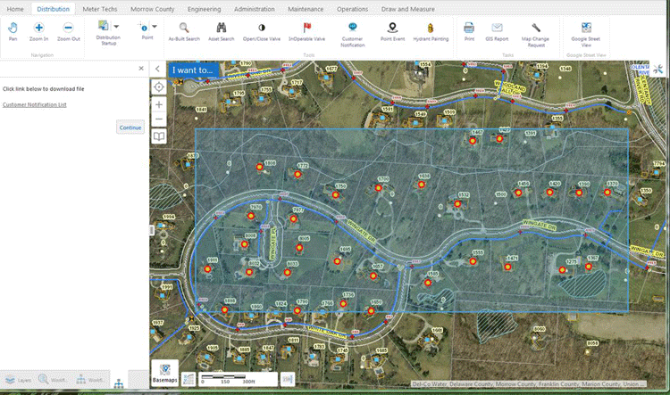
Using GIS to Streamline and Automate Asset Management
Michael Boyd from Novotx writes about how Del-Co Water Company in Ohio uses GIS to to automate workflow processes and streamline operations.

After the Map GIS Data Available
A bonus to the book, After the Map, is the companion site, www.afterthemap.info which offers access to all of the imagery, spreadsheets, and GIS data used in the book.

GIS and Underground Mining
GIS has been utilized to monitor tunnels and areas explored, as it provides both 3D visualization and abilities to integrate various sets of data for visual and quantitative analysis.

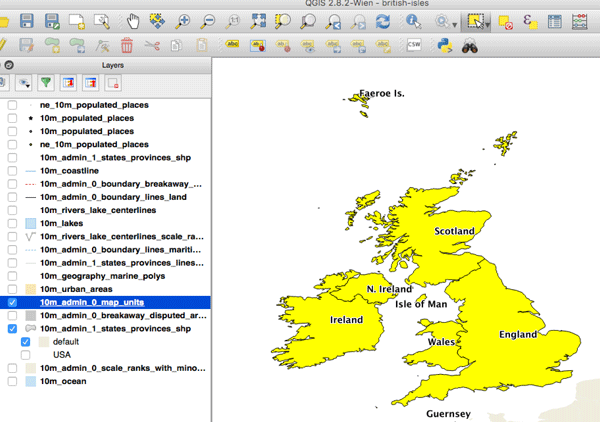
How to Make the Most of QGIS
To get the most out of QGIS it’s not enough to simply know how to write the lines of code you need, and how to integrate with other exciting tools but rather, the more control you have over a tool like QGIS, the more you’ll be able to visualize and explore your ideas.

Building Missing Weather Data
Called the ENACTS (Enhancing National Climate Services) initiative, scientists are using satellite data in order to estimate rainfall, temperature, and other information to fill in a 15 year gap in climate data collection for Rwanda.

Using GIS to Choreograph Dance
Researchers at Ohio State University developed GIS software to help track the movement of dancers over time to see their patterns, which was also then used to choreograph new classical routines
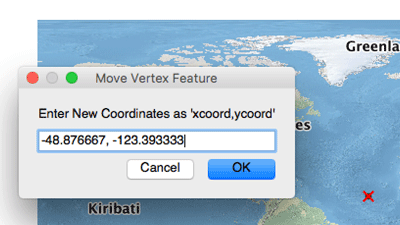
How to Map a Single Set of Coordinates Using QGIS
Here are the steps you need to follow if you want to map a single set of coordinates with QGIS.

Using GIS During Fire Season
Every year, GIS users get better at assembling data and creating meaningful maps that help decision makers predict fires, set fire risk levels, and deploy assets in the most efficient manner possible.
How to Convert a Selection into a New GIS Dataset Using QGIS
Here is a step-by-step tutorial on how to convert a geographic selection from one GIS dataset into a new GIS file using QGIS.

How GIS is Used to Understand History
Historical geography is one area that has applied GIS to understand outcomes of battles, why cities were built in given locations, and using ancient technologies to understand length and difficulty of travel at different times of the year.

GIS and CAD Integration
Mark Altaweel discusses efforts to create a truly integrated system, where CAD components and software concepts work with GIS data.