
GIS and Geospatial Technologies
Articles focusing on the application of geographic information systems (GIS), geospatial technologies, remote sensing, LiDAR, and Global Positioning System (GPS). These technologies serve as critical tools for understanding and interacting with our physical environment. GIS allows for the mapping and analysis of spatial data Geospatial technologies refer to the various tools used to measure and analyze Earth’s lands and resources. Remote sensing provides a way to collect data from a distance, often via satellites or high-flying aircraft, and is commonly used for environmental monitoring and military applications.
GIS subcategories :
GIS Career | GIS Data | GIS Industry | GIS Learning | GIS Software | GPS | Remote Sensing | Spatial Analysis

Using GIS and a Century of Data to Create a New Geologic Map of Alaska
In 2016, the USGS completed a new geologic map of Alaska using GIS.

GIS and Artificial Intelligence Used to Build Facebook’s World Population Map
Facebook has used a combination of existing GIS data, high resolution imagery, and artificial intelligence to develop a detailed population map of the world.

Take Map Design to the Next Level with QGIS
QGIS Map Design provides step-by-step instructions covering both basic styling and labeling and advanced cartographic techniques such as illuminated contours and dynamic masking.

Secure Geocoding
World Geocoder for ArcGIS allows users the ability to secure map out addresses and locations from behind a firewall.

Free Trial of Drone2Map: Turn Drone Imagery into GIS Ready Data
Esri has released its beta version of Drone2Map will enables user to quickly develop GIS ready data from drone imagery.

Open Source Big Spatial Data with GeoMesa
Bob DuCharme, a technical writer with CCRi, writes about how open source GeoMesa can help users with managing large spatio-temporal datasets. GeoMesa can stored petabytes of GIS data and serve up tens of millions of points in seconds.

Volunteer to be a Digital Humanitarian and Help With Mapping Projects
The Humanitarian OpenStreetMap Team is able to provide mapping services in large part due to its army of volunteers. Find out ways that you can get involved with HOT.

Developing Earthquake Damage Maps from Satellite Imagery
Researchers are working on developing remotely sensed maps that may assist locals in assessing damage and managing the aftermath with future earthquakes.

How to Embed Mapillary’s Street Level Imagery Into Any Mapping Platform
MapillaryJS is a platform-agnostic WebGL JavaScript library for displaying street level photos which allows for integration with a variety of mapping applications.

Garmin Acquires DeLorme
Garmin announced the news on February 11, 2016 that it had signed a purchase agreement to acquire DeLorme.

How GIS Supports the Planning and Development of Smart Cities
The Smart City model uses robust GIS for building urban resilience. The GIS framework seamlessly integrates with other technologies supporting visualization and analysis in real time. This becomes the mainstay of ‘smart’ management providing resource optimization, open and participatory governance and efficient management of city infrastructure.

A Web Mapping Tutorial for Beginners
This tutorial by Ardit Sulce guides users through how to create a web map using QGIS.

Automatic Acquisition of 3D City Models
This concept paper on the automatic acquisition of 3D city models was written by Venugopalan Nair who is the Senior Manager of Geo Spatial Services at SBL.

South Dakota’s Custom Enterprise System to Increase Wildlife Management
The Wildlife Inventory and Land Management Application (WILMA) is a web-based application allowing habitat managers to map, track, and report various land management activities on Game Production and Water Access Areas in South Dakota.
Commercial GIS Software Applications
Listed below are GIS software packages that provide all-encompassing mapping and spatial analysis capabilities via the desktop.

Seafloor Mapped Using Measurements of the Earth’s Gravity Field
Researchers have developed a gravity map used to see the sea floor based on Earth’s gravitational field.
Preparing for Urban Pandemics Using GIS and Resilient IT Systems
Geospatial modeling has found that if 30% of the population voluntarily isolated themselves for 8-10 weeks, the total people infected would drop by almost half.

Creating Administrative Choropleth Maps Using R
Learn how to create Administrative Level 1 Choropleth Maps in R with this tutorial by Ari Lamstein.
Transit Explorer: Mapping all of North America’s Transit Routes
Transit Explorer is a mapping application that visualizes current, planned, and proposed transit routes across Canada, the United States, and Mexico.

How to Implement an Effective UX Design Strategy
A designer’s voice on the relevance of User Experience (UX) design in modern GIS application development.

What is a Shapefile?
The shapefile format is now a common format for storing GIS data. Shapefiles store non-topological vector data along with related attribute data.

Line of Sight: Track the Real Time Locations of Satellites
Line of Sight is an online map application that tracks where each and every satellite is above the Earth in real time.

Make Agile Work for You: Six Practices for Location Based App Development
This article takes a look at the Agile process in use at Timmons Group which focuses on six practices: adaptive planning, iterative development, early delivery, continuous improvement, rapid and flexible response to change, and promoting teamwork.

Who is the Father of GIS?
Roger Tomlinson, known as the "Father of GIS," coined the term "geographic information systems."
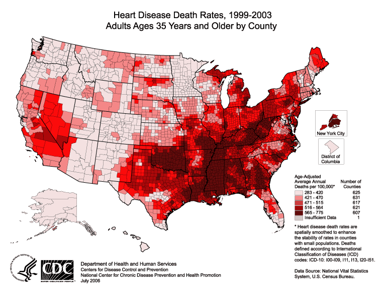
Where Have You Been? Using GIS to Analyze Residential History and Health Care
Troy Lambert takes a look at how the power of GIS can be leveraged to greatly influence healthcare as we know it.

GIS in Oil and Gas
The Oil and Gas industry is leveraging GIS through a seamless integration of geospatial technologies like UAV, sensors and existing computer systems.