
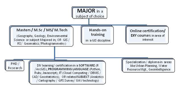
GIS and Geospatial Technologies
Articles focusing on the application of geographic information systems (GIS), geospatial technologies, remote sensing, LiDAR, and Global Positioning System (GPS). These technologies serve as critical tools for understanding and interacting with our physical environment. GIS allows for the mapping and analysis of spatial data Geospatial technologies refer to the various tools used to measure and analyze Earth’s lands and resources. Remote sensing provides a way to collect data from a distance, often via satellites or high-flying aircraft, and is commonly used for environmental monitoring and military applications.
GIS subcategories :
GIS Career | GIS Data | GIS Industry | GIS Learning | GIS Software | GPS | Remote Sensing | Spatial Analysis

GIS and IoT Business Applications
Augmenting IoT data with interactive GIS mapping can significantly improve understanding of spatial data.

The Future of Street Level Photos in Mapping
Using mobile phones, 360-degree cameras, car dashboards and helmet cameras, Mapillary’s users take geo-tagged pictures of the roads they travel which the app automatically uploads to Mapillary’s platform. Then, Mapillary stitches the photos together and turns them into an immersive, navigable, street level view of the world.

Your Mobile GIS Ecosystem
Lowell Ballard discusses the concept of branding your mobile “portfolio” to better create that sense of a unified ecosystem to ensure that clients know that they are using one of your applications.
The Many Aspects of a Career in Geospatial
Sangeeta Deogawanka takes a look at the GIS/geospatial arena that is increasingly embracing new technologies within the spatial niche.

WalMap: The App By Walgreens That Maps Out Community Trends in Real Time
Walgreens uses GIS to power its Flu Index Map, visually tracking flu spread for better healthcare decisions and increased public awareness.

Using Remote Sensing to Count Trees
Tree count management using remote sensing techniques is important for sustaining conservational stability and ecological biodiversity.

Cloud Computing Used to Analyze Landsat Imagery and Detect Deforestation
Landsat, NASA’s longest running initiative for the acquisition of Earth imagery, has generated nearly 50 trillion pixels of data by capturing one image per season, of every place on Earth, for the past 43 years, providing a treasure trove of data for researchers.
GIS vs. Surveyors Court Case to Start on GIS Day
Instead of celebrating GIS on November 18th, one company will be defending its GIS and GPS services as a case against them will start oral arguments in Pennsylvania.
How to Make a Tile Grid Map Using Excel
Step-by-step tutorial for creating a tile grid map of the United States using Excel.

A Brief History of GIS
From the early days in Canada to the high tech world of internet mapping, the field of GIS is older than you may think.
Researchers: Satellite Imagery Could Boost Wildlife Conservation
An increased number of scientists, conservationists and technology scions are banding together to use their various strengths to benefit conservation efforts to track global biodiversity.

Stanford Geophysicists Map What Lies Beneath Southern California Using High-Resolution Sensors
Stanford University researchers mapped subterranean risks in Southern California by measuring human-induced body waves on city streets and sidewalks.

Five Applications of Satellite Data
To illustrate the benefits, here are five uses of satellite imagery and data.

Orbital Insight Shows How Artificial Intelligence (AI) Can Be Used to Study Images from Space
Orbital Insights has developed a “deep learning” processes which uses artificial intelligence to pull data from satellite imagery.

Your Mobile Portfolio: Make it Your Own
Lowell Ballard, Director of Geospatial Solutions for Timmons Group, discusses the importance of making users feel like a part of your company's ecosystem by developing a mobile portfolio.

Advanced Techniques for Measuring Human Behaviors in Urban Public Spaces
Researchers at the University of Copenhagen utilized a combination of thermal cameras, computer vision technology, and GIS analytics to geo-reference the movements of pedestrians in order to asses public spaces.

Satellite Imagery Provides Insights to Global Questions and Changes the Data Landscape
Data extracted from satellite images have been helpful for tracking everything from the number of customers at retail and restaurant chains to tracking the rates of deforestation.

How Government Organizations Are Using Location Intelligence to Drive Digital Engagement
This opinion piece by James Brayshaw, Vice President of LI and Spectrum Business with Pitney Bowes, takes a look at how location intelligence is helping local governments make timely and accurate decisions.
Drones and GIS: A Look at the Legal and Ethical Issues
The ethical and legal issues about gathering geographic data using drones can be divided into four main areas: regulations, privacy, safety, and noise.

Spatial Law and Geospatial Applications
Taking a look at spatial and and geospatial applications, this is the third of a three-article series on Spatial Law that focuses on the issues surrounding spatial technologies, the responsibilities and legalities thereon.

Spatial Law and Geospatial Technologies
Taking a look at spatial and and geospatial technologies, this is the second of a three-article series on Spatial Law that focuses on the issues surrounding spatial technologies, the responsibilities and legalities thereon.

Spatial Law, Policy, and Geospatial Technologies: A Comprehensive Overview
Taking a look at spatial law and its application within GIS is the first of a three-article series on Spatial Law that focuses on the issues surrounding spatial technologies, the responsibilities and legalities thereon.

Extracting 3D GIS Data
This piece by Anil Narendran Pillai, Vice President of Geomatics at SBL, takes a look at 3D GIS data creation using feature extraction methods.

Measuring the Number of Trees in the World
Using a combination of satellite imagery, forest inventories, and supercomputer technologies, researchers estimate there are 3.041 trillion trees in the world.

Chimpanzee Behavior Analyzed Using Innovative GIS Application Offers Insight to Our Human Past
A group of scholars has developed an innovative new application of GIS to understand stone tool use behaviors in chimpanzees during nut-cracking season.

David or Goliath: Establishing Your Mobile GIS Portfolio
Lowell Ballard, the Director of Geospatial Solutions for Timmons Group, discusses the David versus Goliath approach in developing robust and full-featured versus smaller more focused mobile GIS applications.