
GIS and Geospatial Technologies
Articles focusing on the application of geographic information systems (GIS), geospatial technologies, remote sensing, LiDAR, and Global Positioning System (GPS). These technologies serve as critical tools for understanding and interacting with our physical environment. GIS allows for the mapping and analysis of spatial data Geospatial technologies refer to the various tools used to measure and analyze Earth’s lands and resources. Remote sensing provides a way to collect data from a distance, often via satellites or high-flying aircraft, and is commonly used for environmental monitoring and military applications.
GIS subcategories :
GIS Career | GIS Data | GIS Industry | GIS Learning | GIS Software | GPS | Remote Sensing | Spatial Analysis

Working with Coordinate Reference Systems: Mastering QGIS
This section of the free chapter preview of Mastering QGIS looks at working with coordinate systems in QGIS. Mastering QGIS is designed to bring users who want ...

Styling Vector and Raster Data: Mastering QGIS
This section of the free chapter preview of Mastering QGIS looks at styling vector and raster GIS data in QGIS. Mastering QGIS is designed to bring ...

Adding Functionality with Plugins: Mastering QGIS
This section of the free chapter preview of Mastering QGIS looks at using plugins to extend the functionality of QGIS. Mastering QGIS is designed to bring ...

Composing Maps: Mastering QGIS
This section of the free chapter preview of Mastering QGIS looks at making maps in QGIS. Mastering QGIS is designed to bring users who want to go ...

Editing Data: Mastering QGIS
This section of the free chapter preview of Mastering QGIS looks at editing GIS data in QGIS. Mastering QGIS is designed to bring users who want to ...

Working with Tables: Mastering QGIS
This section of the free chapter preview of Mastering QGIS looks at working with tables in QGIS. Mastering QGIS is designed to bring users who want ...

Loading Data: Mastering QGIS
This section of the free chapter preview of Mastering QGIS covers loading different data types into QGIS desktop. Mastering QGIS is designed to bring users who want ...

How Crowdsourced Mapping is Supporting Relief Efforts in Nepal
When Nepal was hit by an earthquake of a icagnitude 7.8 on 25 April 2015, it was a disaster, unprecedented ...

Geointelligence – Empowering Geospatial with Intelligence
Geointelligence is the use of GIS and other geospatial technologies to help with defense and military operations.

Big Data, GIS, and Bikes
The Oregon Department of Transportation (ODOT) has set a precedent for public agencies across the country with the purchase of ...

Defining Waterfall and Agile GIS Project Management Styles
Lowell Ballard, the Director of Geospatial Solutions for Timmons Group, takes a look at effectively engaging clients for GIS projects. ...

LiDAR and Rail Utility Mapping and Digital Asset Preparation
Venugopalan Nair, Senior Manager, SBL, discussed why LiDAR is an efficient and quick technology for mapping rail utilities.
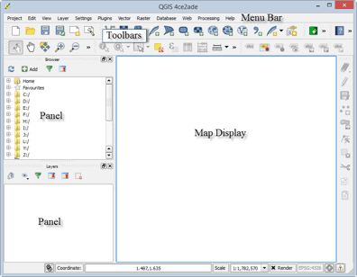
Tour of QGIS: Mastering QGIS
This section of the free chapter preview of Mastering QGIS covers the graphical user interface components of both QGIS Desktop and QGIS Browser. Mastering QGIS is ...
QGIS Download and Installation: Mastering QGIS
This section of the free chapter preview of Mastering QGIS covers downloading and installing QGIS. Mastering QGIS is designed to bring users ...

Learn about GIS in the Cloud
GIS technology and processing in the cloud is on the way to becoming the next big trend. The various functionalities of the cloud can be suitably tailored to fit into an organization’s geospatial workflow.


Ensuring the Future of GIS with Geospatial Education
The U.S. government is helping to guarantee the future of GIS by investing billions of dollars in geospatial education. The ...
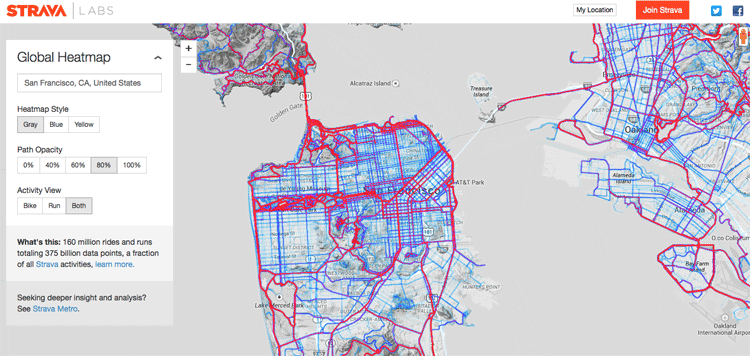
Creating a Global Heat Map from 41.5 Million Runs
Strava, a GPS running and biking application, recently released a detailed global heat map of popular routes across the globe. The map contains over 160 million activities with 375,000,000,000 data points.

Solving Field GIS Wireless Connectivity Issues with Web Apps
WebMapSolutions enhances offline GIS capabilities in the browser by integrating JavaScript widgets that extend functionality in any web app.

Using Satellite Imagery to Track the Ocean’s Acidity
The Earth’s oceans play a vital role in the health of the planet. ocean dynamics impact weather patterns, it provides ...

Maps Serve to Monitor Global Agriculture
As the world’s population grows, the amount of land available for farming is becoming a major concern. Increasing competition for ...

How Spatial Big Data Underpins Smart Cities
Underpinning any smart city program is trusted geospatial information; one single source of reliable, location-specific data.

Using a Heat Map to Show the Level of Happiness by Province in Turkey
Dogus Guler created a heat map showing levels of happiness by province in Turkey using GIS.

Geoportals
Geoportals provide a single point of access for searching for and downloading GIS data from a multitude of sources. Users looking for GIS ...

Free Field Survey Tools
With the immense leaps of cheaper data storage, cellular availability, and awareness toward open source components, the options to create ...

Using Geospatial Technologies to Save the World’s Peatlands
Rezatec has developed “Peat spotter”, a service that uses Earth Observation imagery to locate and create initial mappings of peatlands. This information is enriched with ground data collected by field agents using handheld devices.