
GIS and Geospatial Technologies
Articles focusing on the application of geographic information systems (GIS), geospatial technologies, remote sensing, LiDAR, and Global Positioning System (GPS). These technologies serve as critical tools for understanding and interacting with our physical environment. GIS allows for the mapping and analysis of spatial data Geospatial technologies refer to the various tools used to measure and analyze Earth’s lands and resources. Remote sensing provides a way to collect data from a distance, often via satellites or high-flying aircraft, and is commonly used for environmental monitoring and military applications.
GIS subcategories :
GIS Career | GIS Data | GIS Industry | GIS Learning | GIS Software | GPS | Remote Sensing | Spatial Analysis
New GISP Certification Process and Fees Announced
The GIS Certification Institute (GISCI) announced new terms and fees for its certification and recertification processes starting July 1, 2015.

Abstract Machine: Applying GIS in the Humanities
In Abstract Machine: Humanities GIS, Charles B. Travis, a senior research fellow at Trinity College Dublin in Ireland, uses case studies from history, poetry, and published works to explore out GIS analysis is used to explore and understand events in literature, history, and culture.
Building Better Maps for the Visually Impaired
For those of us who can see, being able to read a map is something that we take advantage of ...

Saying “I Love You” With GPS
Aspiring Romeos around the world have been employing their GPS tools in order to give a voice to their valentines.

Esri Launches Site to Find Open Data
Esri has launched ArcGIS Open Data as a portal for users to search, download, and visualize open data: Since July 2014, ...
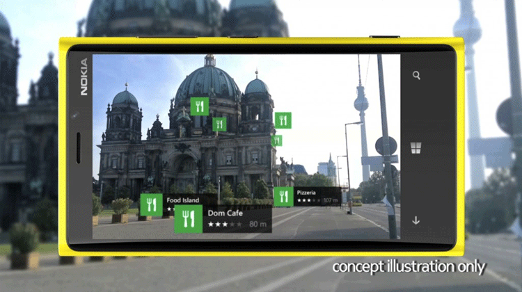
Augmented Reality and the Digital Map Revolution
Groundbreaking technology called augmented reality is affecting digital maps, changing how we find and discover the world around us.

The 25th Anniversary of the U.S. Census Bureau’s TIGER Project
It is something that many of us take for granted every day. If we need to find directions to an ...

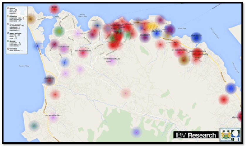
Using GPS Data to Help Cities in Emergencies
In October of 2012, Hurricane Sandy struck the East Coast of the United States causing billions of dollars in damage. ...

Early Efforts to Measure the Circumference of the Earth
For centuries individuals have been creating ways to accurately measure various aspects of the Earth using the tools of their times.
Fun with GPS
A multitude of games and alternatives have emerged to capitalize on the affordability of handheld GPS units.
Empowering GIS with Big Data
Analysis of Big Data in a geographic context has empowered organizations and businesses faced with huge amount of data and diverse technologies. The integration of maps with multiple layers of information tells the full story behind the data. Trends and patterns are revealed. Queries are answered and new questions are also addressed. At the same time, predictive modeling on massive datasets help drive accurate decision-making, profitability and effective resource management.

Using GIS to Identify Milwaukee’s Homeless Population
GIS Cloud has developed a mobile GIS and mapping app that allows for the collection of information about homeless populations in the City of Milwaukee in Wisconsin.
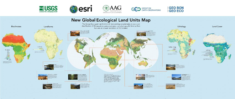
Global Ecological Land Units Map
Esri and the United States Geological Survey (USGS) have developed the highest spatial resolution ecological land units (ELUs) map of the world commissioned by the intergovernmental Group on Earth Observations (GEO).

A Case Study in Environmental GIS: Light Pollution Mapping
Geospatial consultant Marcus Hinds uses remote sensing and environmental GIS methodologies to study light pollution in the Greater Toronto Area in Canada.

GISconnector for Excel – Synchronize Data, Selections, and Filters between ArcGIS and Excel
A new tool is available called GISconnector for Excel which enables bidirectional data transfer between ArcGIS and Excel. The tool, GISconnector, also ...

Disconnected Editing with ArcGIS in the Browser
Matt Sheehan discusses disconnected editing for ArcGIS and the libraries that Web Map Solutions has developed to provide users with disconnected capabilities to any ArcGIS web app in the browser.

Focusing GIS Apps on the User’s Needs
Timmons Group's Lowell Ballard stresses the importance of preventing scope creep in GIS app development to keep them focused and user-friendly.

Generalization in GIS
Generalization is the method used in GIS to reduce detail in data. Learn about how to generalize GIS data using QGIS, ArcGIS, and other software tools.

Land Surveying and GIS Revisited: An Unnecessary Drama
Joseph Magnotta presents an opinion piece about the relationship between surveyors and the GIS industry and why it doesn't need to be contentious.

Latest Release of MapInfo Focuses on an Easier to Use Mapping Experience
Pitney Bowes, the maker of MapInfo, has released an updated version of the GIS software that is aimed towards lowering ...

How GIS is Being Used in Conservation Biology
GIS has a central role in analyzing the geographic distribution of endangered species, in measuring and monitoring biodiversity, and in identifying priorities for conservation management.

Four Ways GIS is Being Used to Help Populations Vulnerable to Long Term Climate Change
GIS is changing the way vulnerable populations relate with their natural world and resources to keep ahead of imminent climate changes.

Using Geospatial Technologies to Map Illegal Fishing
Worldwide overfishing is having a devastating effect on marine ecosystems. A 2014 report from the United Nations Food and Agriculture Organization ...

Mapping the California Drought with Open Data
The Center for Integrated Data Analytics (CIDA) of the United States Geological Survey has created an open source visual description of California's ongoing drought using free and publicly available GIS data sources

Using Drones to Create Fast Orthorectified Maps
Computer scientist Mark Pritt, along with colleagues at Lockheed Martin in Gaithersburg, Maryland, developed a new algorithm to handle thousands of images and speed up the process of creating an orthorectified map from UAV aerial imagery.