
GIS and Geospatial Technologies
Articles focusing on the application of geographic information systems (GIS), geospatial technologies, remote sensing, LiDAR, and Global Positioning System (GPS). These technologies serve as critical tools for understanding and interacting with our physical environment. GIS allows for the mapping and analysis of spatial data Geospatial technologies refer to the various tools used to measure and analyze Earth’s lands and resources. Remote sensing provides a way to collect data from a distance, often via satellites or high-flying aircraft, and is commonly used for environmental monitoring and military applications.
GIS subcategories :
GIS Career | GIS Data | GIS Industry | GIS Learning | GIS Software | GPS | Remote Sensing | Spatial Analysis

National Geospatial-Intelligence Agency’s Web Mercator Advisory Notice
The National Geospatial-Intelligence Agency (NGA) has an advisory notice warning about errors in the widely used Web Mercator map projection.

Mapping the Outbreaks of Diseases
In August of 2014, the World Health Organization declared a public emergency in response to the growing number of Ebola ...

Where is the Cloud in GIS for Watershed Management?
Barbara Horvatic, the Marketing Manager at GIS Cloud, explains how using a cloud-based GIS can help create a collaborative environment ...
Is GIS Use in Crime Analysis Effective at Curbing Crime?
A new study by researchers at Sam Houston State University found that the use of GIS is widespread in analyzing crime ...

Mapping Global Carbon Dioxide Emissions
Researchers recently published the results of developing a system for measuring global carbon dioxide (CO2) emissions in the Journal of Geophysical ...

Mapping Forest Disturbance with Landsat
The Landsat Ecosystem Disturbance Adaptive Processing System (LEDAPS) takes advantage of the 30 year Landsat archive to inventory recent disturbances and forest-cover change.

Some Common Spatial Analysis with Raster Data
Spatial coincidence, proximity, surface analysis, dispersion, and least-cost path analysis are some common spatial analysis done with raster GIS data.

Create Your Own Mental Maps with MindRider Helmets
A mapping application called MindRider hopes to improve biking experiences by creating mental maps of routes with the help of a special helmet.

A Spatial Analysis of Moscow’s Fuel Stations
Andrey Pirogov, a lecturer at the Lomonosov Moscow State University Business School, describes his project to map out and analyze fuel station locations in Moscow, Russia.

Binning in GIS
Binning in GIS helps group data into categories, making it easier to see patterns and densities on maps.

What is the Difference Between a Heat Map and a Hot Spot Map?
Learn about the difference between Heat Maps and Hot Spot Maps in GIS.

EarthCube Data Initiative
Improvements in technology have led to the wide dissemination of information. As long as you have a computer, tablet, or ...

Using Unmanned Aircraft to Help Map Threatened Plant Species
Geography researchers at Central Michigan University have tested out the usability of UAVs in mapping out threatened plant species.
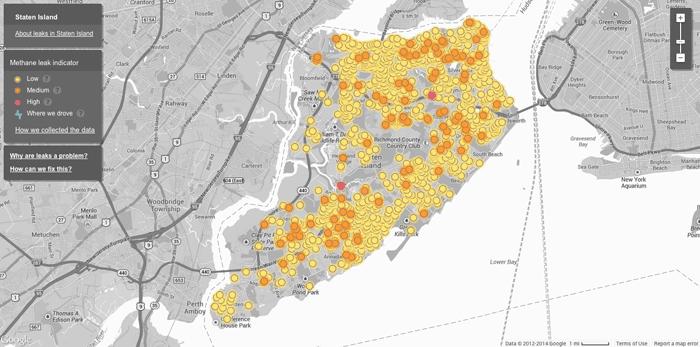
Mapping Methane Leaks with Google Street View Cars
Google partnered with the Environmental Defense Fund on a pilot project to use Google’s fleet of Street View cars to ...

No Drones Zones: Map and GIS Data
Unmanned aircraft, known more commonly as drones, have a blanket ban by the Federal Aviation Authority in the United States over military ...

Using Remote Sensing to Measure the Effect of Drought on Ground Water
This map shows a comparison of modeled relative amount of water stored in underground aquifers in the continental United States for July 7, 2014 as compared to the average for comparable weeks for the sixty year average water storage.
Evaluating Ecosystems from Space
The ESA has launched their Space for Ecosystem project in order to more accurately evaluate the benefits of a natural resource.

Views From the 2014 Esri International User Conference: GIS In Imagery
Photographer Kristina Jacob shares moments she captured from the 2014 Esri International User Conference that was held in July in San Diego, California.

Mapping Soil Moisture from Space
Soil moisture might not be considered a critical factor to the health of our planet but a series of satellite ...

GIS Tutorial for Python Scripting
GIS Tutorial for Python Scripting is a new release from Esri Press. This workbook contains hands-on programming exercises to familiarize GIS users ...
Esri Launches GeoNet
Timing its announcement with the start of the annual Esri International User Conference, Esri has announced the launch of GeoNet, ...

USGS Report on the Uses and Benefits of Landsat Imagery in Water Resources
The USGS recently published a report looking at case studies of Landsat Imagery use in water resource management within public ...

Esri Releases Explorer for ArcGIS for Mac OS
Data viewer from Esri for MacOS which offers limited functionality to "access maps, search for and visualize data."

GIS Data of the World’s Wetlands
There are currently 2,185 sites worldwide that the Ramsar Convention considers to be wetlands of international importance representing over 208,597,750 hectares. GIS Data for Ramsar sites is available from Wetlands International.
Gender in the GIS Workforce
This article takes a look at the state of gender balance in the GIS industry.

Statistics for Thematic Cartography
The Geographic Information Technology Training Alliance (GITTA) has an online lesson plan that provides some helpful information about creating thematic maps. ...