
GIS and Geospatial Technologies
Articles focusing on the application of geographic information systems (GIS), geospatial technologies, remote sensing, LiDAR, and Global Positioning System (GPS). These technologies serve as critical tools for understanding and interacting with our physical environment. GIS allows for the mapping and analysis of spatial data Geospatial technologies refer to the various tools used to measure and analyze Earth’s lands and resources. Remote sensing provides a way to collect data from a distance, often via satellites or high-flying aircraft, and is commonly used for environmental monitoring and military applications.
GIS subcategories :
GIS Career | GIS Data | GIS Industry | GIS Learning | GIS Software | GPS | Remote Sensing | Spatial Analysis

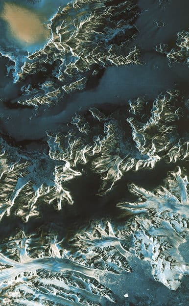
Access CryoSat-2 Ice and Ocean Data Products
CryoSat-2 has been collecting data since its launch in 2010, allowing scientists to better understand changes in the thickness of polar sea ice, the elevation of the ice sheets that blanket Greenland and Antarctica, and mountain glaciers.

Mapping Time: A Detailed Look at Minard’s Flow Map
Mapping Time: Illustrated by Minard’s Map of Napoleon’s Russian Campaign of 1812 combines historical and geographic analysis with cartography to examine mapping change over time.

Verifying Ancient Roman History with GIS
Tom Whitley, an Assistant Professor of Archaeology at the University of Western Australia (UWA), used GIS to test population estimates and patterns of migration and war to see how the historical aspects known about the Gallic Wars measures up to geophysical evidence.

Remotely Tracking Growth of the Sugarcane Industry in São Paulo, Brazil
The use of remote sensing technologies to track the development of the sugarcane industry is a topic of much attention

Crowdshipping: the Newest Development in Mobile GPS
Crowdshipping is the delivery of goods based on the selection of a courier closest to the delivery route. The service ...

GIS Data of the World’s Glaciers
An international group of seventy scientists hailing from more than eighteen countries have created the first global datasets of the ...

ASTER and the Spectral Recipe for Finding Gold
In the last section of this series, we took a look at both the ASTER sensor and the vast library of ...

NASA’s Global Precipitation Measurement
Water is essential for life on the Earth, and the supply of this precious liquid is constantly being recycled through ...

How to Share ArcMap (.mxd) Files
Learn how to set up your GIS data and symbol sets so that you can share ArcMap .mxd files with others.

Overview of Public Health and GIS
This article provides an overview of the use of GIS as in public health. It includes a short history of its development as a tool in the field, explains how GIS is used, different data sources and how the privacy of sensitive health information is maintained. Examples of current research using GIS within the public health field are also provided.
First Satellite Images from Sentinel-1A
Launched on April 3 and reaching operational altitude on April 11, the first images captured by the European Space Agency’s ...

Call for Translators: gvSIG
The developers of open source GIS software gvSIG have issued a call for translators. gvSIG is a freely downloadable GIS ...

Overview of Fuzzy Logic Site Selection in GIS
Site selection is a type of GIS analysis that is used to determine the best site for something and fuzzy logic is one site selection method. It assigns membership values to locations that range from 0 to 1 and is commonly used to find ideal habitat for plants and animals. This article examines fuzzy logic and explains how and when to use it.

Overview of Weighted Site Selection and Suitability Analysis
Site selection is a type of analysis used in GIS to determine the best place or site for something. Weighted site selection analysis is one type of site selection that allows users to rank raster cells and assign a relative importance value to each layer. This article examines weighted site selection by explaining how it works and when it should be used. It also provides an example of a weighted site selection project for reference.
GPS Experts Call for Safeguards After GLONASS Outage
The Russian GLONASS global satellite navigation system went down for 13 hours on April 2, but it’s not causing much ...
Overview of Least Cost Path Analysis
This article presents a summary of least cost path analysis, an important tool in GIS. Least cost path analysis is a distance analysis tool within GIS that uses the least cost path (the path between two locations that costs the least to those travelling along it) to determine the most cost-effective route between a source and destination. This article provides an overview of that topic as well as the requirements and steps for creating a least cost path analysis.

Overview of Flow Mapping
Flow maps are a type of map used in cartography to show the movement of objects between different areas on the Earth’s surface.

3D Mapping with Google Smartphones
Project Tango is an initiative from Google that could revolutionize how the world is mapped and navigated.

The ASTER Spectral Library – a True Monument of Remote Sensing Data
In the first part of this series, Cameron Windham from Apollo Mapping takes a look at the nuts and bolts of the widely-used ASTER Spectral Library.

GIS and Gaming
This article delves into the convergence of GIS and the video game industry, exploring their existing partnership and mutual benefits.
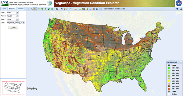
Use of GIS in Agriculture
By using GIS to map current (and potential) farmland scientists and farmers can work together to create more effective and efficient farming techniques.

Imagery and Its Use in GIS
Most imagery for use in GIS projects consist of satellite images or aerial photographs but it can also include, thermal images, digital elevation models (DEMs), scanned maps and land classification maps. This article examines imagery and how to effectively gather, store, process and interpret it for a variety of different GIS projects.
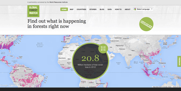
Global Forest Watch: A Real-Time Mapping Project
Data from Global Forest Watch, an online forest monitoring and alert system is now available via an online mapping platform. Users of this data portal can add maps, datasets, and applications to their forest projects and better analyze indicators of forest change.

The Rainforest Magician – Optical Illusions and the Spectra of the Canopy
The findings of a recent paper published in Nature found a sun-sensor geometry arrangement was the cause for historically high readings of green-ness in the rainforest canopy.

Danie Krige and Kriging
This article provides a biography of a Danie Krige, and presents a short overview of geostatistics and kriging.
“Interoperability” for the Surveying Profession
Gavin Schrock, PLS, the editor of Professional Surveyor Magazine, writes about the surveying field changing in the face of the ...