
Physical Geography
Physical geography focuses on geography as an Earth science (and is sometimes called Earth System Science).
Physical geography is a branch of geography that focuses on the study of the natural features and processes of the Earth’s surface. It includes the examination of landforms, climate, vegetation, soils, and water resources. Physical geographers use a range of scientific methods and tools to analyze and understand the complex interactions between the Earth’s physical systems.
Learn about the different branches of geography that fall under the physical geography category: climatology, geomorphology, biogeography, and more.

The World’s Smallest Mountain Range
Surrounded by flat farmland, the Sutter Buttes are an isolated volcanic landform often described as the world's smallest mountain range.

Human-Driven Extinction of Birds
Researchers using models and historical records estimate that up to 11% of all bird species have gone extinct since the Late Pleistocene.

This Bird is Not the Only Crested Jay West of the Rocky Mountains
Since the 1960s, blue jays have steadily expanded their range beyond the Rocky Mountains into western North America.

Weather Forecasting Using Artificial Intelligence
GraphCast is a Google DeepMind effort that uses deep learning to improve medium-range weather forecasting.

Measuring Tree Height with a Pair of Satellites
Using synthetic aperture radar (SAR) data from two satellites, researchers developed a method for estimating tree canopy height.

Using Animals to Collect Weather Data
Attaching sensors to wildlife could give scientists fine-scale weather data from the habitats animals move through.

How Sea Level Rise Will Affect Salt Marshes
Researchers have calculated that about 90 percent of salt marshes are under threat from rising sea levels predicted to occur by the year 2100.

American Chestnut: the Struggle to Save the ‘Redwood of the East’
Scientists and conservationists are working to rescue the American Chestnut from going completely extinct.

Surge Flows: A Rare River Phenomenon
Surge flows are a rare phenomenon where shallow waters, sand or sediment, and steep topography combine to create waves in rivers.
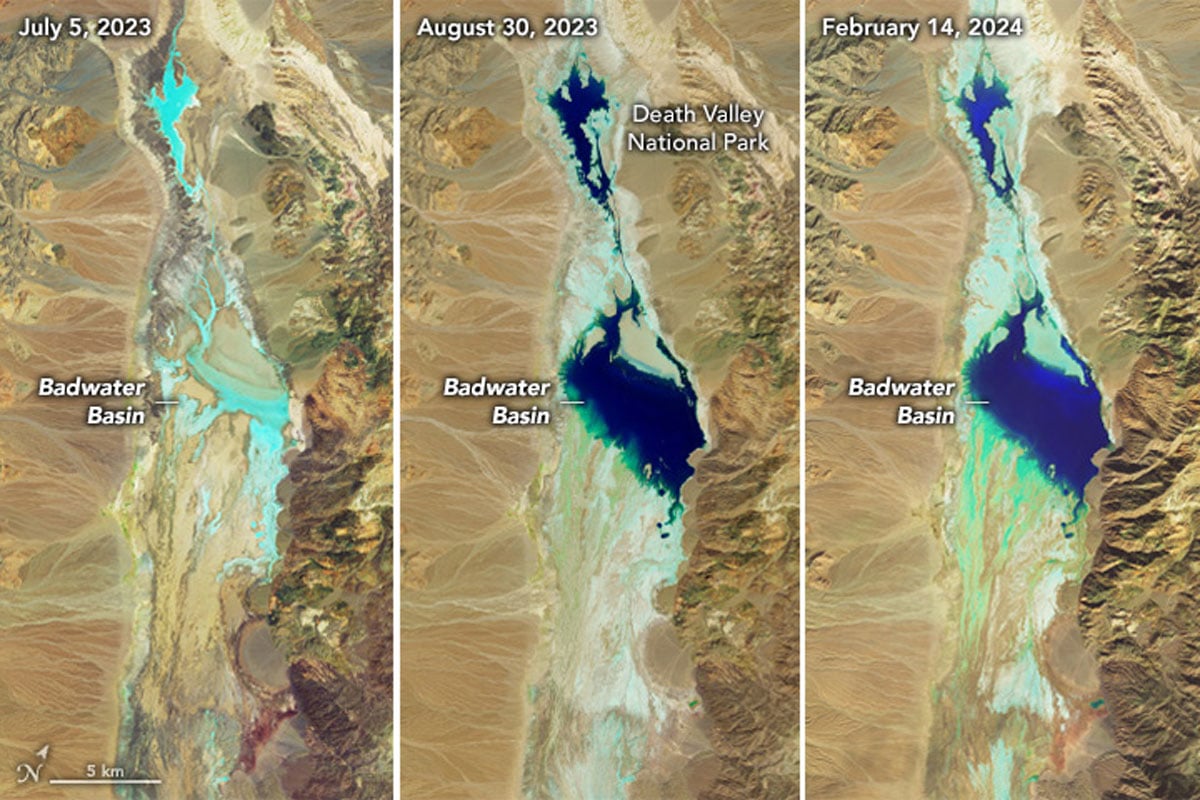
North America’s Lowest Point on Land is Currently a Lake
Two recent heavy rainfall events have filled Badwater Basin, the lowest point in North America on land, up with water.

Geography of Lightning Strikes in the United States
Researchers recently mapped out data from the U.S. National Lightning Detection Network (NLDN) between 2017 and 2022 to see where lightning strikes the most across the contiguous United States.

Why Climate Change is Making Some Animals More Nocturnal
As daytime temperatures rise, some animals are becoming more active at night to avoid heat stress.

Individual Seabird Adaption to Climate Change
Scientists tracked the migratory patterns of 145 seabirds to map how individual shearwaters are adapting to climate change.

Geography of Atolls
Atolls are ring-shaped coral reefs, islands, or a series of islets that encircle a lagoon either partially or completely.

The Role of Secondary Forests in Reducing Atmospheric Carbon
Secondary forests play an important role in carbon capture strategies aimed towards reducing atmospheric carbon.

Using GIS to Map an Individual Animal’s Home Range
GIS can be used to model animal home ranges using location data collected through radio telemetry and GPS tracking.

What is the Outlook for California’s Atmospheric Rivers?
During the winter months, atmospheric rivers carry enormous amounts of water to the state of California.

What is England’s Highest Mountain?
Found at 978 metres (3,209 ft) above sea level, Scafell Pike is located in Lake District National Park in Cumbria.

Sea Otters are a Keystone Species
Keystone species are plants or animals, like the sea otter, whose presence in an ecosystem plays a crucial role in its health.

Mapping Glacier Loss in Western Canada
Researchers are using remotely sensed data and satellite imagery to map glacier loss in Western Canada.

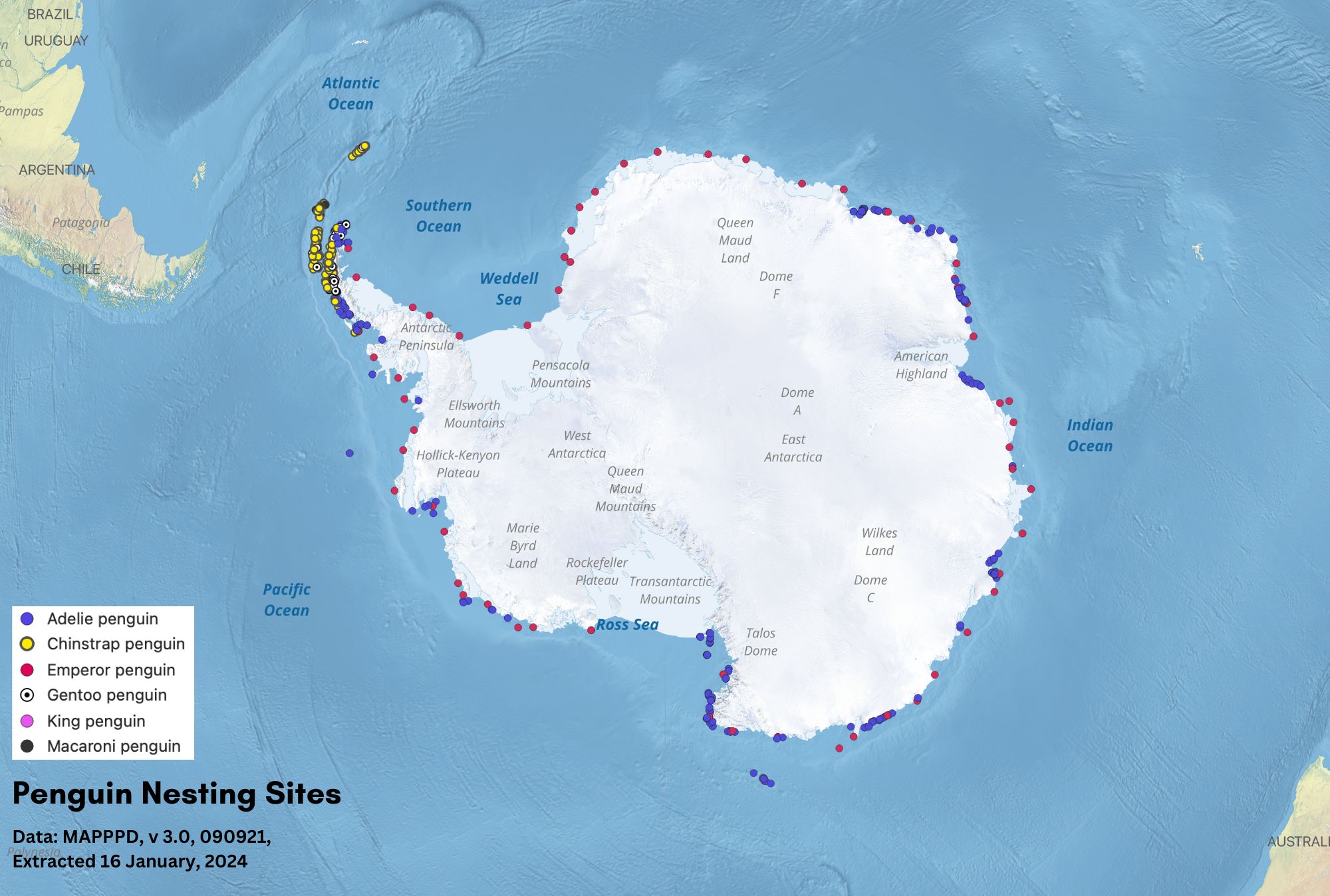
Geography of Penguins
Discover where penguins live, from Antarctic sea ice to tropical islands, and what shapes their geographic distribution.

Geography Facts About the Southern Ocean
The Southern Ocean is the Earth's windiest, southernmost ocean and plays a vital role in Earth's environmental health.

Exploring Rainbows and Moonbows
Rainbows and moonbows occur when light is refracted through drops of water in the sky.

What is Snowliage?
Snowliage is when an early winter storm creates a bright white snowfall that contrasts with the red, oranges, and yellow fall foliage of trees.

The Highest 11 Mountains in the United States
Learn about the highest 11 mountains in the United States.