
Physical Geography
Physical geography focuses on geography as an Earth science (and is sometimes called Earth System Science).
Physical geography is a branch of geography that focuses on the study of the natural features and processes of the Earth’s surface. It includes the examination of landforms, climate, vegetation, soils, and water resources. Physical geographers use a range of scientific methods and tools to analyze and understand the complex interactions between the Earth’s physical systems.
Learn about the different branches of geography that fall under the physical geography category: climatology, geomorphology, biogeography, and more.

Study: More U.S. Homes Burn in Grassland and Shrubland Fires than Forest Wildfires
A new study in Science reports that in the United States, grassland and shrubland fires tend to be more extensive and burn more houses than forest fires.

What Are Microforests? Benefits, Criticisms, and the Miyawaki Method
Microforests, also known as Miyawaki forests, are gaining attention as a way to support biodiversity, cool cities, and restore nature in urban areas.
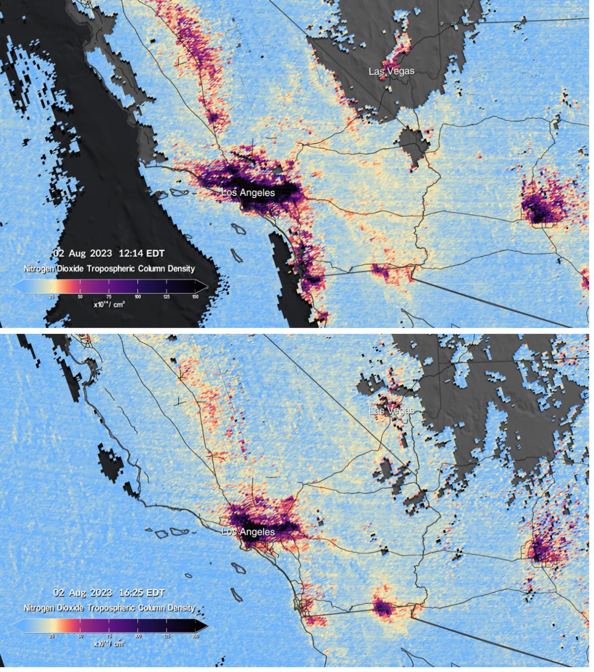
Mapping Air Pollution in the United States
NEMO and TEMPO are two scientific endeavors aimed at producing hourly air pollution maps of the United States.

What is the Difference Between a Crow and a Raven
Here are some ways you can determine the difference between the common raven (Corvus corax) and the American crow (Corvus brachyrhynchos).

Study: Human Activities Have Changed How Wolves Hunt Deer
Logging, linear features, and human infrastructure are changing where wolves hunt for deer.

Rising Sea Levels and Human Migration
Researchers predict that by 2100 between 17 to 72 million people will migrate as a result of coastal land loss due to sea level rise.

Climate Change is Affecting the Color of the Ocean
Researchers are using satellite data to analyzing the levels of phytoplankton in the oceans which are being affected by climate change.

Tallest Active Volcano in Eurasia
With an elevation of 15,597 feet (4,754 meters) Klyuchevskoy is Eurasia's tallest active volcano.

Using Satellites to Map Arctic Amplification
Scientists are using remotely sensed data from Earth observation satellites to map and study Arctic amplification.

Acorn Woodpeckers in Northern California
Acorn woodpeckers can be found in a range of habitats in Northern California where oak trees are present.

Largest Dome Volcano in the World
Lassen Peak is the world's largest dome volcano with a height of 10,457 feet (3,187 meters).

Third Order Islands
Islands with lakes or ponds that contain smaller islands within them are called recursive islands.

A Harbor in the Center of a Volcano
Deception Island is one of the only places in the world where ships can sail directly into the middle of an active volcano.

Where is the World’s Largest Salt Flat?
Salar de Uyuni in Bolivia, is the largest salt flat in the world and one of the world's largest reservoirs of lithium.

Geography Facts about the World’s Continents
Continents are defined as the largest continuous landmasses on earth.

Mapping the World’s Tidal Marshes
The first global map of tidal marsh locations was developed using satellite-based imagery.

Timing Mismatch is Resulting in Fewer Birds
A study has found that shifts in the timing of spring seasons, linked to climate change, are impacting bird breeding patterns and leading to less offspring.

Warmer Ocean Temperatures are Bleaching Coral Reefs
Higher ocean temperatures, along with overfishing and pollution, are leading to more coral bleaching events.

Wildfires in Canada
Canada's boreal forests are facing a strong start to the 2023 wildfire season in Alberta and British Columbia.

Boreal Forests of North America are Shrinking
Boreal forests in North America are defying predictions of northward expansion in response to climate change.

Phytoplankton Blooms in the Northeast Pacific Ocean
During summer in the Northeast Pacific Ocean, phytoplankton blooms proliferate due to the nutrient-rich upwelling along the continental shelf.

2023 Wildfires in the Western United States
So far in early August of 2023, the wildfire season in the western United States has not been as intense as prior years when a years-long drought was raging.

World’s Largest Freshwater Wind Farm
The world's largest freshwater wind farm is the 89-turbine installation in Lake Ijssel located south of the Wadden Sea in the Netherlands.

Potential Collapse of the Atlantic Meridional Overturning Circulation
A new study predicts that the Atlantic meridional overturning circulation (AMOC) could potentially collapse within this century.

Florida’s Burmese Python Invasion
The introduction of the Burmese Python into Florida has resulted in the decline of many native mammals in the Florida Everglades.

When Did the Anthropocene Begin?
The Anthropocene is a proposed geological epoch defined by the significant influence of human activity on Earth's ecosystems and geology.