
climate change

Plant Life is Expanding in the Area around Mount Everest
Using satellite imagery, researchers have found that subnival vegetation, the vegetation that grows between the treeline and snowline, is increasing in spatial extent around the Mount Everest and Himalaya area.

Monitoring Crop Production Via Satellite
To cope with ever-changing agricultural needs and conditions, the USDA’s National Agricultural Statistics Service (or NASS) uses data from Landsat to monitor crops in the contiguous United States.

Biodiversity and Climate Change Adaptation
Many cities globally are forging ahead with climate change adaptation.

The Greenland Ice Sheet Has Lost 3.8 Trillion Tons of Ice
A new report analyzed 26 satellite datasets to track ice loss for the Greenland Ice Sheet.

Sunny Day Flooding is Increasing
Research has shown that the instances of tidal flooding have increased on the Atlantic, Pacific, and Gulf coasts of the United States.

Review | The Citizen’s Guide to Climate Success
This is a most useful primer on climate change and its consequences.

How Wildfires are Changing Boreal Forests and Increasing Emissions
Boreal forests are changing along with our climate.

Where Does the Earth Store All Its Carbon?
It is estimated that 1.845 billion billion metric tons of carbon are settled in mantle and crust, while only 43,500 billion tons can be found on the surface.

Looking at Centuries of California’s Climate to Understand Fire Risk
Researchers examined moisture patterns and atmospheric wind conditions in California using climate models and centuries of paleoclimate data (from 1571 to 2013).

Arctic Permafrost is Now Releasing More Carbon Than it Stores
The researchers found that the Arctic region has transitioned from a carbon sink to a source of carbon emissions.

How New York City is Protecting Its Subway System Against Flooding
A flex-gate is a highly flexible covering that can be quickly deployed to protect a subway's entrance and underground structures in the event of a flood.

How Refugia Will Protect Some Animals and Plants from Climate Change
Scientists and conservationists are working to find refuge areas in order to further land management plans and climate change predictions.
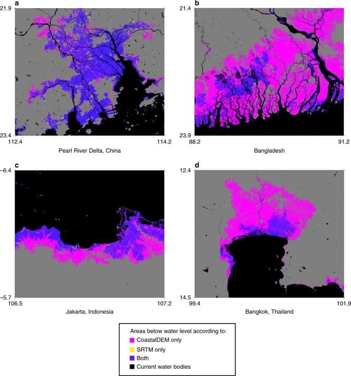
Researchers Estimate Triples the Number of People Affected by Sea Level Rise
New estimates from Climate Central estimate that 340 million to 480 million people would be affected by flooding in coastal areas due to sea level rise.

Mapping Out California’s Methane Emissions
With half of the methane emissions originating from human activities, researchers from NASA wanted to map out point-source emitters in California to understand where the highest volume of methane emissions occur.
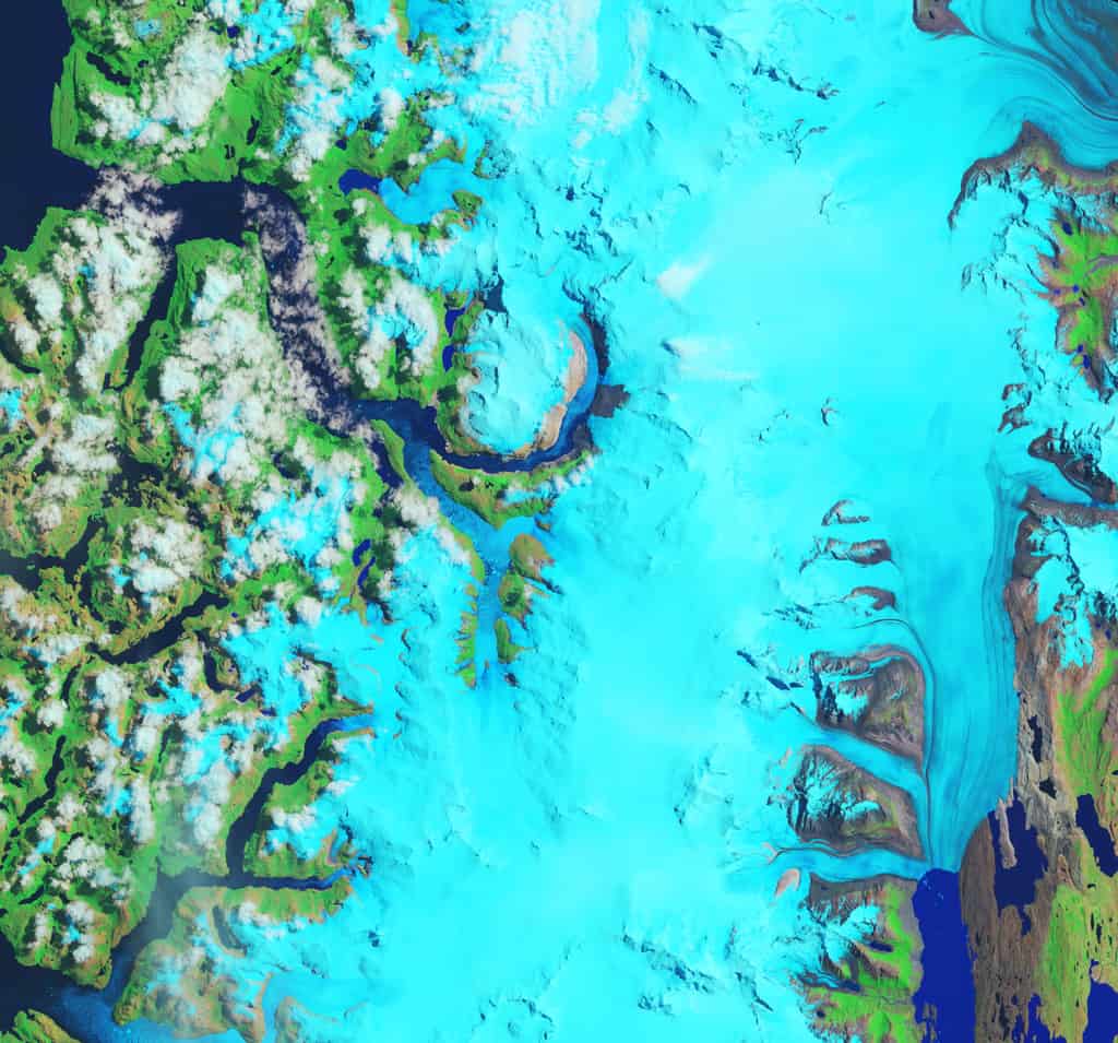
Fastest Thinning Glacier
Hielo Patagónico Sur 12 (HPS-12) in Patagonia is believed to be the fastest thinning glacier in the world.

Earliest Published Research Linking Carbon Dioxide with Global Warming
163 years ago, Eunice Newton Foote was the first scientist to research the link between increased carbon dioxide and a warmer atmosphere.

How Much Carbon Dioxide are the Oceans Absorbing?
New research shows that the world's oceans, which cover 70% of the planet, absorb more carbon dioxide than previously thought.

More Frequent and Intense Tropical Storms Can Change the Geography and Ecology of Coastlines
UNC researchers studied North Carolina tropical cyclones over 120 years.

In The Last Three Years Antarctica Lost Ice the Size of Greenland
A recent report published by the Proceedings of the National Academy of Sciences analyzed satellite data that showed Antarctica’s rapid sea ice decline.

New Findings on How Trees Impact Droughts
Recently published research looked at the question of, "Instead of looking at how drought affects the forest, how might this go the other way around?"

Greenland’s Ice Arch Crumbles Earlier Than Normal
Across the Nares Strait, between Greenland and Ellesmere Island, lies a horizontal ice arch.

The U.S. is Losing 36 Million Trees Per Year
A study from the US Forest Service has found that, nationally, tree cover is declining at a rate of 175,000 acres per year which is the equivalent of about 36 million trees lost each year.

Mapping Where Planting Trees Can Help with Climate Change Mitigation
Researchers have mapped out where to plant trees to mitigate climate change.

Climate Change is Intensifying Drought in Southern California
Researchers from UCLA and Columbia University discovered that the 2012–16 drought impacted Southern California more severely than northern regions.

The Arctic Permafrost is Thawing and It’s Causing Thousands of Landslides
Using Banks Island, Canada as a study area, researchers analyzed trends in permafrost thaw and associated landslides.

Help Map Out Australia’s Dead Trees
By using a GPS-enabled smartphone, volunteers can capture imagery of tree health around Australia to help researchers map out where trees are dying in Australia.