
Articles

The Adams Event – Did Polar Drift Cause Climate Change 42,000 Years Ago?
Some 42,000 years ago, Earth went through several centuries of dramatic climate change and environmental chaos.

Mapping Our World, Saving Lives with Humanitarian OpenStreetMap Team
The “Mapping our World: Saving Lives” episode of the AfricaGeoConvo Podcast, examines the world of mapping and volunteering, with Geoffrey Kateregga.

Storms of the 2021 Hurricane Season
While the official 2021 hurricane season officially lasts from June 1 to November 30, 2021, the first storm of the season has already happened.
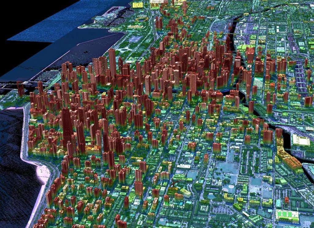
Geiger-mode Lidar and Geospatial Data Acquisition
Paul Nash discuses Geiger-mode lidar and its use in geospatial data acquisition.

NASA Completes the First Global Survey of Fluctuations in Lakes and Reservoirs
ICESat-2 launched in September 2018) with its satellite laser altimeter, allowing NASA to perform the first global survey of freshwater fluctuations.

Ethics in GIS
With more ways to gather geospatial data and share that information, ethics has become even more important to consider.

3 Tips to Help You Get a GIS Promotion
This article from Bootcamp GIS provides tips for how to get promoted in GIS.


Cybersecurity and GIS
GIS can play an important role in ensuring protection of vital infrastructure and data networks.

How to Use ArcGIS Pro to Estimate Areas Prone to Malaria
This tutorial uses Spatial Data Science and Remote Sensing techniques (ArcGIS Pro) to estimate areas that are prone to malaria using ArcGIS Pro.

Preparing for a GIS Job Interview
Navigating the interview process for a GIS position can be challenging due to the field's wide skillset requirements - here are some tips.

Coldest Temperature of Clouds Recorded by a Satellite
Researchers measured the coldest temperature ever recorded by a satellite of a cloud.

Terrestrial Ecoregions GIS Data
The terrestrial ecoregions dataset is available both in shapefile format and as a Google Engine dataset.

Deepfake Satellite Imagery
Deepfake satellite imagery is imagery that has been synthetically to alter or change the appearance of an image, often replacing one scene for another.

Tracking Plastic in the Air
Approximately 1,100 tons of microplastics are thought to be floating in the air above the Western United States

5 Reasons why the GIS industry continues to grow
If you work in GIS, you have seen tremendous growth in software sales, services, and solutions over the past 20 years.

3 Tips to Maximize the Value of Your GIS Internship
Andres Abeyta, the Executive Director of Bootcamp GIS, discusses three ways to get the most of your GIS internship.

Securing a Funded GIS Graduate Program
Adebowale Daniel and Nnenna Nkata from the AfricaGeoconvo podcast share important information about securing a GIS graduate program.


80% of Plastic in the Ocean Comes From 1,656 Rivers
A team of researchers analyzed where geographically rivers are the biggest sources of plastic pollution entering the ocean.

Introduction to Geography: Exploring The World Around Us
Geography is the science that studies the Earth and the physical and human influences that shape it.

How the 2020 U.S. Census Shifted Congressional Seats
With the 2020 Census, seven states lost seats and six states gained seats in the House of Representatives.

Carbon Mapper: A Collaboration to Map Greenhouse Gas Emissions
A new, non-profit organization, Carbon Mapper, is attempting to create better ways to pinpoint methane and CO2 emissions.

Climate Change and the Expansion of Ghost Forests
Along the geography of the East Coast of the United States, large swathes of forest are declining at increasing rates.

Views of Earth from Space
Over the decades, Earth has been captured from near and far by astronauts and spacecraft from space.

Review | Under the Wave at Waimea
Set in Hawaii and with a champion surfer as its central character, "Under the Wave at Waimea" introduces us to the global geography of surfing.