
Articles

GIS and Territorial Disputes
The use of GIS for mapping territorial disputes has played both a positive and negative role in resolving these disputes.

Nighttime Illumination Continues to Grow Worldwide
A new study used remotely sensed data from an earth observation satellite to analyze the rate of increase in artificial night lights between 2012 and 2016.

When Predictions Match Reality: The Power of LiDAR for Flood Warnings
LiDAR data is being used to develop highly accurate elevation-enabled flood inundation mapping in advance of major storms in North Carolina.

Map of Cold and Hot Temperature Anomalies Across the World
NASA has compiled a temperature anomaly map of the world using data acquired between December 26, 2017 and January 2, 2018.

Mappy New Year! Celebrate with Vintage Map Postcards
To celebrate the New Year, here are some vintage map themed postcards.

Watch Landsat 8 Imagery Acquisition in Near Real-time
The FarEarth Global Observer offers visitors the opportunity to view near-live streams of Landsat 8 imagery being acquired in near real-time.

Seafloor Mapping Techniques
Today, seafloor mapping is essentially a form of remote sensing that uses similar concepts and applications to satellite-based systems, albeit adapted to the complex environment of the oceans.

Holiday Season Gift Ideas Created by the GIS Community
Looking for a holiday gift idea for the geographers in your life and want to support the GIS community? Listed here are some great gift ideas produced by geographers.

GIS File Formats
Listed here are some of the more common file formats along with associated file extension for GIS file types.

Is the Newly Revised Geospatial Data Act Worth Supporting?
Anthony Calamito, Chief Geospatial Officer of Boundless, explains why Boundless stands behind the new Geospatial Data Act.

How to Save a Selection as a New File Using QGIS
Learn how to save a selection from a GIS dataset to a new GIS file using QGIS with this quick video tutorial.

Hurricanes, Sea Salt, Dust, and Smoke
This visualization from the Global Modeling and Assimilation Office (GMAO) at NASA's Goddard Space Flight Center shows how particles flow around the Earth's atmosphere.
NAIP Aerial Imagery Might be Moved from the Public Domain to a Licensing Model
The Farm Service Agency (FSA) is considering moving its National Agriculture Imagery Program (NAIP) from a free aerial imagery service to a licensing model starting the 2019 fiscal year.

Mapping the 11 Lost Cities of the Bronze Age
New research methods have led to the narrowing of the search for 11 different Bronze Age cities that have been lost to the tides of time, thanks to new quantitative data analyses by some dedicated economists.
The Rise of Femtosatellites
Femtosatellites, very small-scale satellites (weighing less than 100 grams / 0.22 lbs), have developed over the last fifteen years thanks to advances in nanotechnology.

Rapid Response Monitoring Tools
With rapid data access, new vehicles and tools that can go almost anywhere (e.g., such as unmanned aerial vehicles), and more efficient computing, we are witnessing an age of rapid response monitoring that addresses environmental and social problems as they develop.

Scientists are Improving How They Track Hurricanes with New Satellites
The Atlantic hurricane season in 2017 has given researchers the opportunity to perfect some of their previous methods and put into practice new instruments used to track hurricanes.

How Deep are the Earth’s Tectonic Plates?
Researchers have been able to create a better picture of tectonic plates by using both earthquake vibrations and seismic waves.

UAVs, GIS, and Ecology
With the relatively cheap price and increasing effectiveness of unmanned aerial vehicles (UAVs), often called drones, we are seeing much more accurate estimates and understanding of ecological change.

Will 2017 be Remembered as a Stellar Time for Earth Observation?
Joe Francica, Managing Director Location Intelligence Solutions with Pitney Bowes discusses the growth and direction of Earth Observation satellites.

Monitoring Air Pollution with Sentinel-5P
Sentinel-5p will be one of the first satellites that provides high resolution pollution monitoring and will provide a large data capture that enables daily and even hourly monitoring.
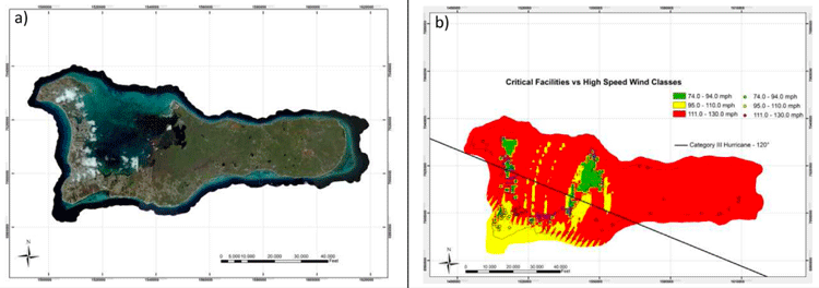
Predicting and Assessing the Impact of Hurricanes with GIS
GIS has become an important tool in assessing the risk of hurricanes and estimating the impact of damage that they may cause.

Cost Distance and GIS
GIS can be used for cost distance mapping by factoring a variety of variables, ranging from economic, social, cultural, environmental, or other barriers to analyze the ‘cost’ in travel or movement.

Tropical Forest Degradation Means More Carbon Dioxide is Released into the Atmosphere Than is Absorbed
Satellite images targeting areas of tropical Asia, Africa, and the Americas have shown that some tropical forests are dispelling more carbon than they are taking in.

Sensing Longitude Among Birds
A study has shown that the Eurasian reed warbler is able to sense magnetic declination and use that information to determine their migratory flight path.

Introduction to Density Mapping With GIS
Density mapping shows where points or lines are concentrated. GIS tools like ArcGIS and QGIS provide point density analyses.