
Mark Altaweel

Using R with GIS Software
With the utility of R, many popular statistical procedures and more advanced analyses, including a variety of simulation applications, can be applied directly within GIS tools such as QGIS.

Using GIS to Assess and Mitigate Rail Hazards
GIS has been of interest to rail companies, NGOs, and governments attempting to minimize a variety of hazards that may affect the rail network.

Geography and Modern Slavery
Human geographers examine the interplay between economics, neoliberal capitalism, geography, and immigration to identify potential hotspots for human trafficking and slavery

GIS and Semantics: Enabling the Discoverability of Data
Much like the semantic web, methods exist in GIS to streamline the search of diverse geospatial data through certain protocols and standards.

Analyzing Risk for Radioactive Materials Using GIS
Earlier GIS studies focused on analyzing safe routes for transporting radioactive materials, while recent ones have quantified the storage risk.

Geography and Inequality
Simple examples of geographic social inequality can be found in major cities, where wealthier urban people generally have access to more housing, food shops, basic amenities, healthcare, and other infrastructure than the urban poor.
How Geography Influences Voting Behavior
Voter turnout in elections is heavily influenced by factors such as geographic proximity to polling places. Voter turnout is influenced by a variety of factors, including race, district size, district redrawing, and even weather.

Geography of Conflict
Geography can show us how physical and social factors shape global conflict today and in the past.

Using GIS in Landscape Archaeology
Landscape archaeology is a discipline where space is critical to understanding ancient settlements and human use of ancient space. The use of GIS is steadily growing as a tool in this field.

Using GIS to Understand Species Evolution
Studies have used spatial modeling and GIS approaches to understanding species evolution.

Geography and Globalization
Globalization, significantly impacting society, has been a popular subject among human geographers.

GIS and Innovations in Machine Learning
Machine learning or artificial techniques has been rapidly transforming many areas related to GIS and spatial applications

GIS and Social Activism
Groups promoting various causes are implementing geospatial approaches and GIS related technologies.

How Spatial Modeling Can Help with Refugee Aid
GIS is being used to address the spatial problem of allocating resources and constructing refugee camps.

Making 3D Models with Photogrammetry
With the prevalence of smartphones and drones, photogrammetry is now widely present as an effective and cost-efficient method to easily recreate 3D models of large areas and specific objects or buildings.

How GIS Can Help Dentists Find Cavities
GIS is making inroads in dentistry, where dentists now use spatial technologies for diagnosis and dental surgery.

How GIS is Helping Gardening
GIS is used in gardening to manage and comprehend the spatial layout of plants, from research and public gardens to home and backyard settings.

Using GIS in Space Exploration
While we generally think of GIS applied to objects or systems on Earth, GIS has been of great utility for space exploration.

Using GIS to Map Telecommunications
Mapping telecommunication networks is of great importance to both urban and rural regions, particularly as telecommunication networks become even more vital for our daily lives. Terrain, vegetation, urban regions, and other potential interference are often assessed together and GIS tools such as ArcGIS have developed into an industry standard for forecasting cellular tower locations.

GIS and Sustainable Energy
GIS has become a critical planning and management tool for addressing where and how to enable sustainable energy efforts.

GIS and Anti-Crime Measures
This article takes a look at methods which demonstrate the wide and growing field of crime prevention utilizing spatial and GIS approaches.
Teaching GIS in Elementary School
Research on how to best implement GIS education for K-12 has looked at the use of web-based GIS and data that is understandable at different levels.
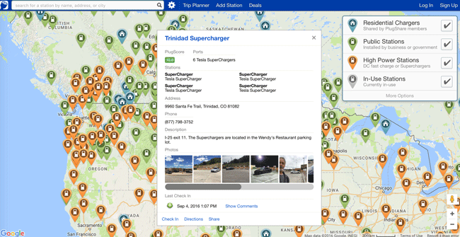
How GIS is Helping Electric Cars on the Road
GIS is playing an important role by helping drivers plan travel that factors in charging stations.

GIS, Pollution, and Health
GIS has been used to assist in showing strong or weak links for given health conditions to different types of pollutants.

GIS and Visualizing Atmospheric Science Data
The use of new data models has allowed more traditional GIS data models to be integrated with those used in atmospheric science.

How GIS Helps Small Ships Navigate
GIS has been utilized in sailing and other small craft to help navigate not just the location of other vessels but also land features and obstacles that may arise or even cause danger to boats.