
Mark Altaweel
Predicting and Assessing the Impact of Hurricanes with GIS
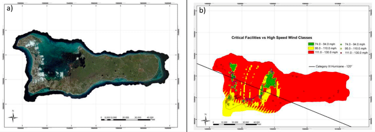
GIS has become an important tool in assessing the risk of hurricanes and estimating the impact of damage that they may cause.

Cost Distance and GIS
GIS can be used for cost distance mapping by factoring a variety of variables, ranging from economic, social, cultural, environmental, or other barriers to analyze the ‘cost’ in travel or movement.

Introduction to Density Mapping With GIS
Density mapping shows where points or lines are concentrated. GIS tools like ArcGIS and QGIS provide point density analyses.

The USGS Landsat Analysis Ready Data (ARD) Program
Landsat data, referenced with WGS84 and provided as GeoTIFF, can be accessed from EarthExplorer for the contiguous US, Alaska, and Hawaii.

Entire National Spatial Reference System (NSRS) to be Modernized in 2022
In 2022, the National Spatial Reference System (NSRS) is scheduled to be modernized, with new reference frames replacing the NAD 83 system and the North American Vertical Datum (NAVD) 88.

Mapping Noise Pollution
As noise pollution continues to be a major issue for expanding urban areas, novel geospatial technologies have been deployed to better monitor and measure noise pollution.
Automated Land Cover Maps
Automating the generation of land cover maps from satellite imagery is becoming easier due to learning-based algorithms improving the understanding of signal data.

Methods for Creating Cloud Free Satellite Imagery: Sentinel 2
Nearly 70% of the globe is covered by clouds at any given time. Several methods have been developed to remove cloud cover from satellite imagery.

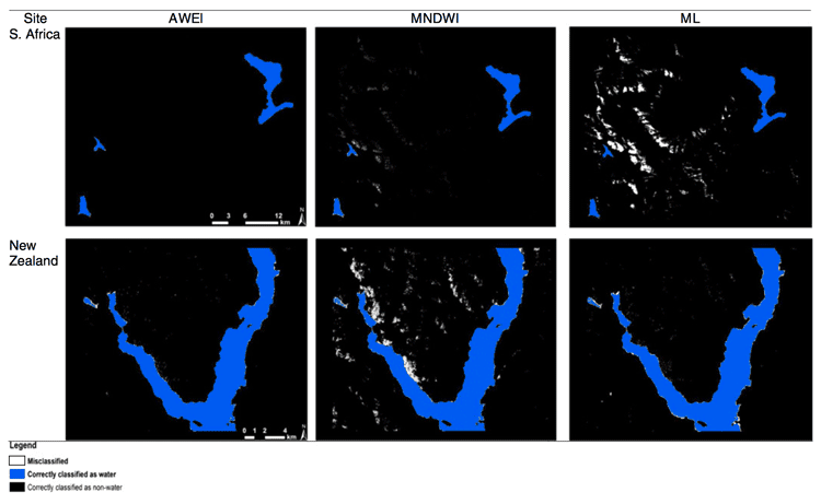
GIS and Machine Learning for Habitat Protection
With gains in computational power and accessibility to off the shelf models, often used in commercial or open source software, applying machine learning techniques with GIS has become far easier for conservation and habitat specialists.
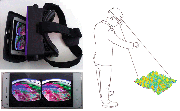
GIS and Virtual Reality
The integration of virtual reality (VR) with GIS is gaining traction in various areas such as urban planning and education.
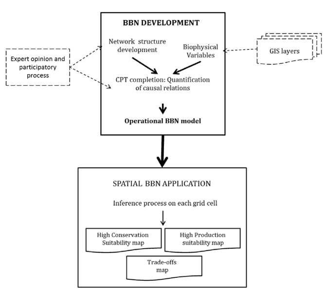
GIS and Bayesian Belief Networks
Bayesian belief networks (BBN) and GIS can be used as decision aides to give an idea of probability of events unfolding.

How Light Pollution Affects People and the Environment
While much of the public is aware of a concept of light pollution, its ill effects and influences on society and nature are less clear to most people.

Where is Open Source GIS Going?
Mark Altaweel discusses the growth and direction of open source GIS tools and software in this opinion piece.
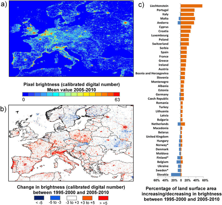
How Geospatial Technologies Are Being Used to Study Light Pollution
Spatial technologies, including remote sensing and GIS, have been used to monitor light pollution and its associated degradation effects.

Noise Pollution and Geography
Noise pollution has long been seen to be particularly acute in regions where transportation and urban development are most pronounced; the disciplines of urban and environmental geography have focused on this topic.
Measuring Vegetation from Satellite Imagery with NDVI
Normalized difference vegetation index (NDVI) is a remote sensing technology that measures vegetation kinds and growth by measuring vegetation fingerprints.

GIS and Stratified Heterogeneity
A method to measure uneven distribution of landscape or population features in a given space is stratified heterogeneity.

GIS and Digital Humanities
GIS significantly influences digital humanities with a spatial focus, increasingly important for various humanities scholars.

The Role of GIS in Wildlife Research and Conservation
Monitoring and studying wildlife habitats has long been a key focus within GIS.

GIS and Advertising
Advertisers are becoming more sophisticated with the use of GIS as a way to better target their audiences.
Persuasive Cartography: How Maps are Used to Shape Our Beliefs
Persuasive cartography involves making maps that attempt to shape our beliefs.

Geography of the Film Industry
Human geographers have studied how the film industry has developed in different countries and regions within countries.

GIS and Flight Training
The future of aviation technology looks to continue to utilize GIS in ways that allow better training and smarter aircraft.

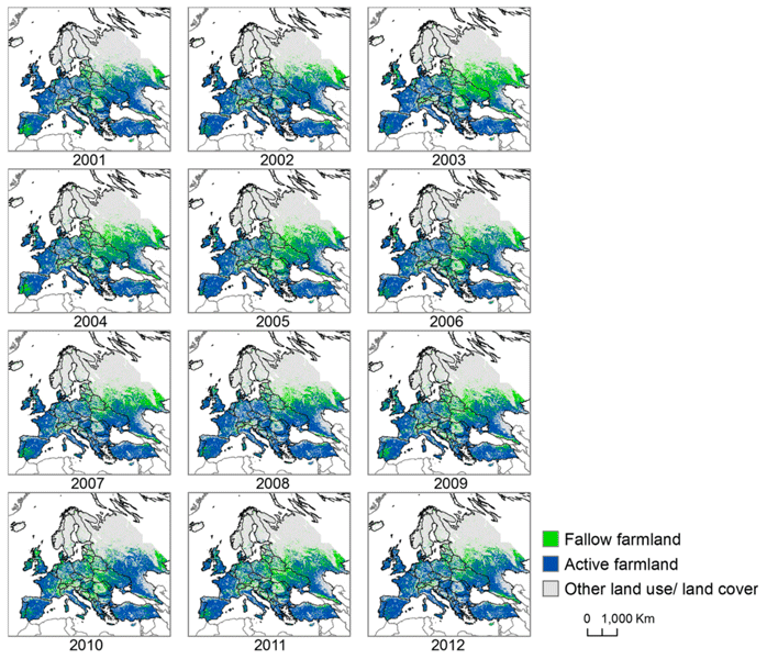
How Geography is Used to Study Agriculture
From climate to key trade and shipping hubs, geography has shaped the fortunes of states and agricultural production.

The Use of Python in GIS
Python today is by far the most widely used language by GIS users and programmers.

GIS and Spatial Autocorrelation
Spatial autocorrelation statistics have become incorporated into commonly used packages such as ArcGIS as well as open source software such as GRASS and QGIS.