
Articles

Geography Facts About the Mississippi Watershed
The Mississippi watershed is the largest drainage basin in North America.

The Foot-trembling Bird Gets the Worm
Foot-trembling is a foraging technique used by some species of birds to find prey beneath the surface of the ground.

This Lake Looks Like a Christmas Tree
The main body of Lake Dukan takes on a triangular shape that looks like a Christmas tree.

The 2018 Statistic of the Year is About Plastic Recycling
90.5% of all plastics that have ever been produced have never been recycled.

Quickly Make a Map Poster From Any Urban Location on Earth
Figuregrounder by Hans Hack is a fun tool that lets you create a simple map poster in seconds.

Free Urban Planning GIS Book and Exercises
An open access book focusing on the use of GIS in sustainable urban planning and management includes six chapters containing exercises and GIS data.

3D Map of Puerto Rico’s Forest Shows How Hurricane Maria Reduced Tree Height
Researchers who compared before and after LiDAR measurements of Puerto Rico's tropical forests found that Hurricane Maria damaged or uprooted 40-60% of the tallest trees.

Interesting Geography Facts About the US-Canada Border
Here are some interesting geography facts about the Canada–United States border.
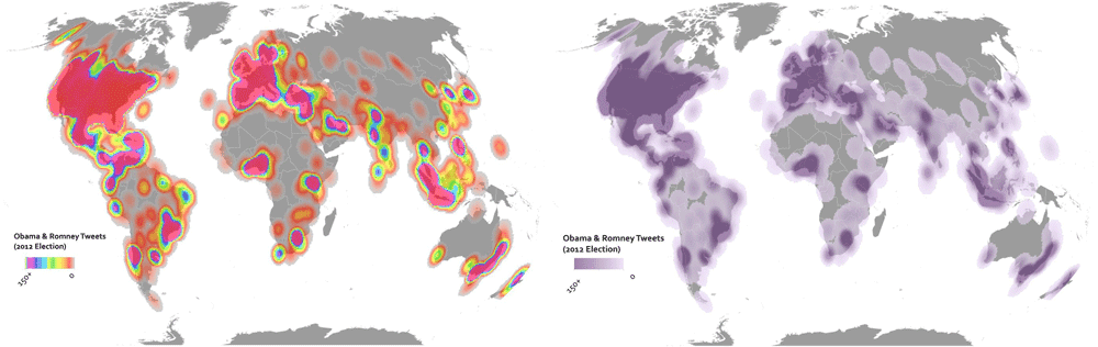
The End of the Rainbow: Picking Color Schemes in GIS
The color symbology in displaying a GIS data on a map is an important decision to make in communicating geographic data.

Mapping the Last Wilderness
An international group of scientists led by James E. M. Watson and James R. Allan mapped the world’s remaining terrestrial wilderness in 2016.

Optimizing Traffic with Autonomous Vehicles and Machine Learning
Improving traffic can be achieved by incorporating geospatial technology in autonomous cars, such as sensors and external information.

When AI Goes Wrong in Spatial Reasoning
Machines can learn ‘wrong’ or biased information, creating large problems and poor conclusions when it comes to spatial data.

Industrial Fishing Has a Global Impact on Bird Populations
A study published in Current Biology - from the Sea Around Us project at the University of British Columbia and French National Center for Scientific Research in Montpellier - provides evidence that industrial fishing practices are starving seabirds around the world.


These Wolves in Minnesota are Very Very Territorial
Researchers with the Voyageurs Wolf Project released maps showing 68,000 GPS-locations of seven wolves being tracked.

How to Make Map Ornaments and Geography Themed Christmas Decorations
If you want to lend a geographic touch to your Christmas celebrations, check out these ingenious geography crafting ideas.

Using Satellite Imagery to Track Volcanic Ash Clouds
Researchers have developed an algorithm that can distinguish between volcanic and non-volcanic clouds using high-resolution satellite imagery.
The Medieval Physician’s Almanac
During the Middle Ages, the belief that spiritual and cosmological forces affected the body and mind was commonly accepted (BBC, ...

Using Machine Learning and Satellite Imagery for Street Address Generation
Facebook and MIT Labs researchers have developed a method employing machine learning and satellite images to create street addresses in regions lacking unique building addresses.
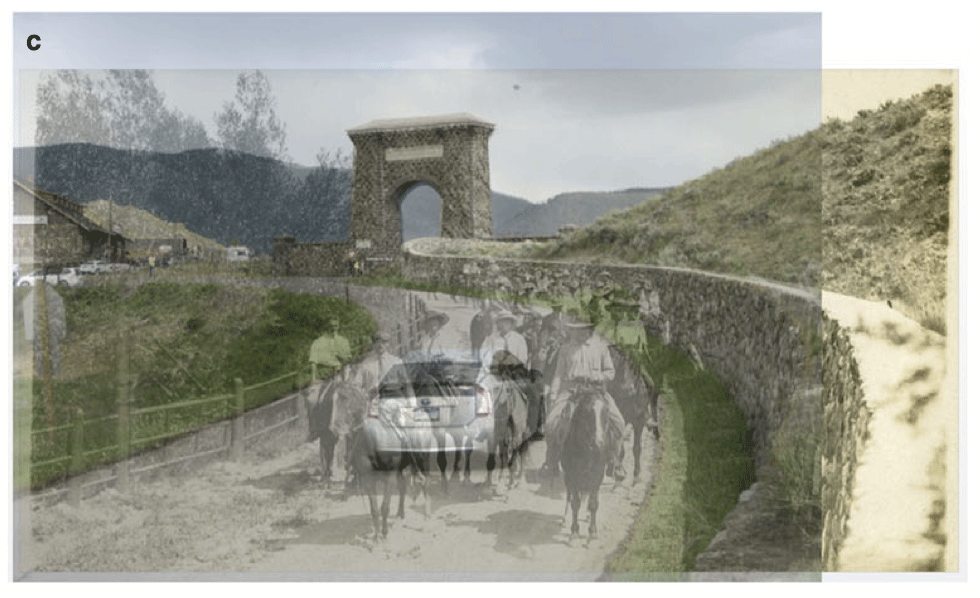
Using Ground-level Imagery to Map Landscape Change
Ground-level photographs have great value to demonstrate landscape change from a human eye-level perspective.

Climate Change Impacting Sea Turtles
What Mass Audubon describes as a, “weather system of gale force winds” is now causing frozen turtles to wash up on New England beaches.
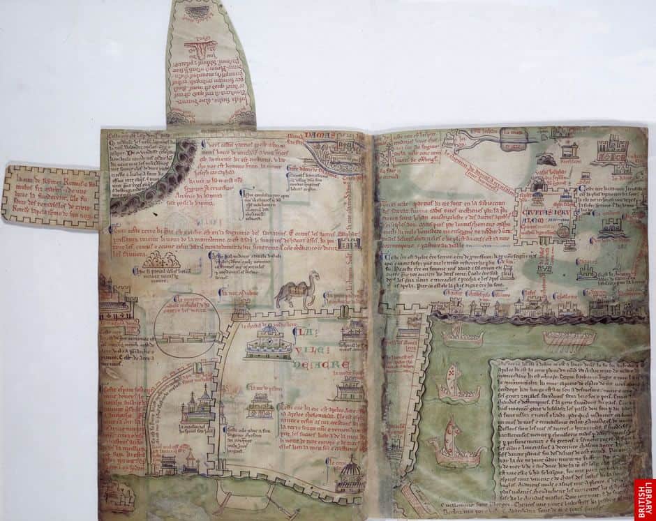
A Brief Look at Medieval Maps and Travel Guides
For many medieval maps created by European cartographers, locations were represented not by their geographic size but sized based on their importance to Christianity.
A Brief Introduction to Medieval Music
Music was an important aspect of Medieval life.

2018 National Climate Assessment Warns of a Future with More Extreme Weather
The 2018 National Climate Assessment presents stark news for climate change and our environment.

2018 Gift Giving Ideas for Geographers and Cartographers
If you're looking for a unique or thoughtful gift for the geo-enthusiast, check out this guide for interesting geography and cartography related gifts for a wide range of budgets.
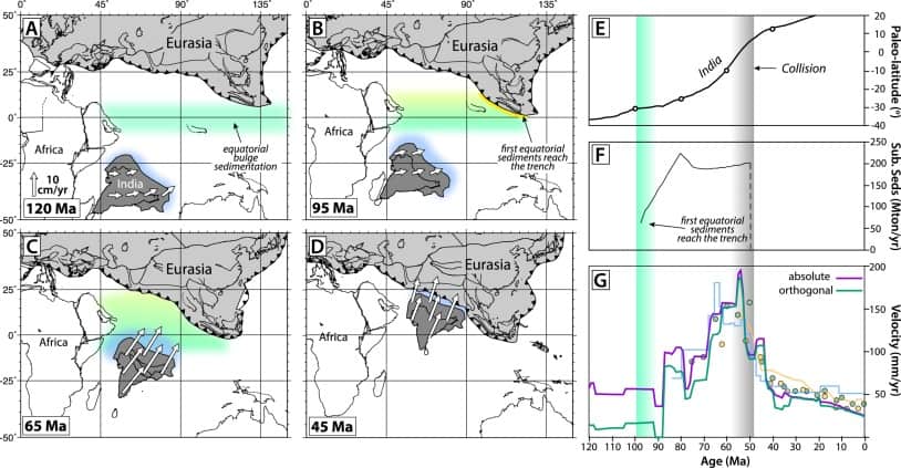
The Link Between Organisms and the Movement of Continents
New research indicates that sediment subducting beneath tectonic plates may regulate their movements.