
Articles

How Texas is Using Geospatial Technologies to Mitigate Forest Fires
Texas A&M Forest Service partnered with Timmons Group, a national geospatial solutions firm, to develop the Texas Wildfire Risk Assessment Portal (TxWRAP).

NOAA Offers Post-Hurricane Aerial Imagery
NOAA has been capturing aerial imagery showing the post-Hurricane Michael destruction across the Florida Panhandle.

Mapping Native Lands
Canadian developer Victor Temprano- founder of Mapster - has created “Native Land,” a map that helps individuals find the original inhabitants of the land they live on.

What a Study of a 130-year-old Brain Coral Means for Open Ocean Health
A team of researchers at Princeton University were able to measure the nitrogen in the coral skeleton to analyze nitrogen pollution, and found it on a far lower level than what had been previously estimated.

Guardacostas Pro: Tracking Illegal Vessels
Argentina’s coast guard, or the Prefectura Naval Argentina will utilize Esri’s platform to create a new, real-time tracking system, aptly titled “Guardacoastas Pro.”

Layers and the Future of Data and Analytics in Business
As location technology becomes more commonplace, democratizing spatial data, and making it accessible to every business profession will be critical to future business planning.

What is the Environmental Insights Explorer (EIE) Tool?
Google has launched a new tool, Environmental Insights Explorer (EIE), with the main purpose of making new climate-relevant datasets easier for cities to access.
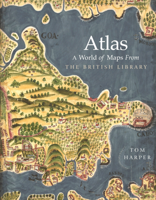
Review | Atlas: A World of Maps from the British Library
Tom Harper's Atlas: A World of Maps from is a ‘definitive showcase’ of the British Library, one of the world’s largest with over four million maps.

Lowest Arctic Sea Ice Minimum Extent for 2018
2018 has tied with 2008 and 2010 for the “sixth lowest summertime minimum extent” for the Arctic based on satellite records.

Study Shows Southern African Ancient Baobabs Are Dying
A study published in the journal Nature Plants found that 9 of out of 13 oldest, and 5 of 6 most massive baobab trees died during the study, many of them suddenly.

Mimicking the Geography of Distance with Letter Writing
Slowly is an interesting social network that reinstates the distance of geography when communicating with others when writing letters.

What Makes Maps Go Viral?
The study of viral geography could be a new, emerging field where researchers are now beginning to look at the elements that make a map viral.

Earth from Above: Green River
An astronaut aboard the International Space Station captured a segment of the river around Boxknot Bend just north of Canyonlands National Park.

Tracking Post-Storm Water Movement Using GPS
NASA researchers recently published a study which uses GPS technology to track water volume and movement post-Harvey

Forecasting Cholera Using Remote Sensing
The NASA cholera forecasting tool effectively takes satellite observations on environmental conditions and combines the data with information on infrastructure and conditions in a country.

Mapping the Best Route for Pedestrian Safety
A team of researchers has published a study that calculates the best pedestrian route based on safety over finding the shortest route.

Mapping Tree Species in the Amazon Using Satellite Imagery and Machine Learning
Researchers have modeled tree species distribution in Peruvian lowland Amazonia using satellite imagery and machine learning techniques.

Florida’s Growing Red Tide
This year’s red tide is so severe that it has forced Florida to declare a state of emergency.

Detecting Storm Intensity from Satellite Imagery Using Machine Learning
The Deep Learning-based Hurricane Intensity Estimator is an experimental portal that uses machine learning techniques to analyze spatial patterns in infrared satellite imagery in order to predict tropical cyclone intensity.

Largest Fires in California’s History
In California, the officially hottest month on the record- July - was topped with the most severe wildfire season that Californians have ever witnessed.
How Plex.Earth is Used in Teaching: An Interview With Professor Martin Cajade
Eleni Natsi of Plexscape interviewed Martin Cajade, a FADU faculty member at the University of the Republic in Uruguay, on his students' use of PlexEarth as a data mining tool.

High Resolution Elevation Data for Antarctica
Recently two high resolution digital elevation models of Antarctica were released for the public to free use.

Google Launches ‘Dataset Search’
Google latest Beta launch, Dataset Search, is designed to make it easier for users to search for and find datasets found across the web.

Startups and the Future of Spatial Analysis
A growing number of startups are developing new approaches to advanced spatial analysis for everyday solutions across many fields and industries.

The Largest Endorheic Lake in the World
The largest endorheic lake also happens to be the largest overall lake in the world.

The Role of GIS Librarians
The learning curve with most GIS software can be lessened with the help of librarians that are able to explain software, recommend useful media, and preserve geospatial data.