
Articles

Extreme Fish Stocking: Repopulating Lakes by Air
To repopulate remote lakes, Utah's Division of Wildlife Resources (DWR) uses airplanes to drop fish into lakes.
GIS and Security Applications
The use of GIS in security software applications allows greater enhancements not just to monitoring but also planning and forecasting potential security threats, both from physical and cyber threats.

What Imagery Source is Best for Your Business?
Erin Jepperson, Technical Sales Engineer at Nearmap, outlines how to weigh the pros and cons of aerial imagery and drone imagery.

A Story Map Journalism Experience
Eudel Cepero shares his experience developing a popular story map for Diario de Cuba using ArcGIS Online.
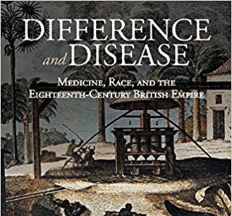
Review | Difference and Disease: Medicine, Race, and the Eighteenth-Century British Empire
The book, Difference and Disease: Medicine, Race, and the Eighteenth-Century British Empire, examines theories of medicine and science within a colonial, racially-mixed population.

Seeing the World with Data: 3D LiDAR with MapD and Uber’s deck.gl
Dipti Kothari, an intern with MapD, has developed an open source project that uses LiDAR to create a 3D visualization of tree coverage around buildings and the impact of rising sea levels on buildings on Jekyll Island, GA.

PaleoDEMs: Map the Earth’s Changing Topography Over the last 540 Million Years
Users can download paleogeographic datasets reconstructing paleotopography and paleobathymetry dating back to 540 millions years ago

GIS and Cancer Screening
GIS can aid cancer screening, especially for cancers linked to environmental, socio-economic, and resource factors.
Mapping Elephant Distribution with Remote Sensing and GIS
A variety of applications using GIS, remote sensing and GPS tracking of individuals per collars have advanced in the last years and are increasingly used for mapping and tracking elephants.

Review | The Ape that Understood the Universe
The Ape that Understood the Universe: How the Mind and Culture Evolve is an engaging, intriguing, and ultimately most satisfying look into what the human mind can do and how it got that way.

Accessing Real-time Satellite Imagery and Data
NASA's LANCE and EarthNow, a space imaging business, are paving the path to real-time and near real-time satellite data.

World Highest Minimum Temperature Record Broken, and Many Follow
The city of Quiryat, Omanon experienced a new world record for the highest minimum temperature on the night of June 26, 2018.

Slower Hurricanes Means More Dangerous Hurricanes
A recent study from NOAA’s Center for Weather and Climate, has found that hurricane speed has slowed significantly in the past six decades

Ocean and Land Observation Data From Sentinel-3B
The main mission of the recently launched Sentinel-3B is to provide quality ocean and land monitoring. As part of the Copernicus program, GIS data and imagery will be made freely available.

Creating Ground-level Views from Satellite Imagery
Recreating a ground-level image and perspective using satellite imagery has only recently been developed.

A New Global Peatland Map Expected for 2020
A new global high-resolution peatland map is expected for 2020.

Geospatial Artificial Intelligence: Emerging Trends and Challenges
There are both challenges and opportunities that Artificial Intelligence (AI) has in applying geospatial and GIS knowledge that also addresses issues of time and spatial bias.

Review | The Consolation of Maps
Set in the world of the international trade in antique maps, this novel’s title seems most apt.
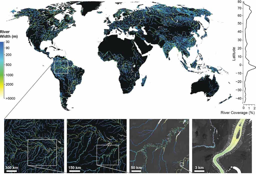
Global Dataset of River Widths Developed from Landsat Imagery
Researchers used a combination of satellite imagery and field measurements coupled with statistical modeling to calculate worldwide river and stream surface measurements which is now available as a GIS dataset.

Interviews with Geographers and Cartographers
Access interviews with prominent geographers from the 1970s to 1990s via the Library of Congress.

Future of Mobile Spatial Applications and Image Recognition
Image recognition software and algorithm development is likely to be increasingly applied with spatial applications.

Will Self-Driving Cars Make Traffic Worse?
The World Economic Forum and Boston Consulting Group studied the possible effects of autonomous vehicles on Boston's future traffic.

Human Eyesight is Sharper Than It Is For Most Animals
A team of researchers from Duke University assesses the visual acuity of over 600 species encompassing insects, birds, mammals, fish, and other animals.
Cormorant: Raven of the Sea
Cormorants are a family of about 40 aquatic birds, mostly of medium to large size. All species of cormorants are ...
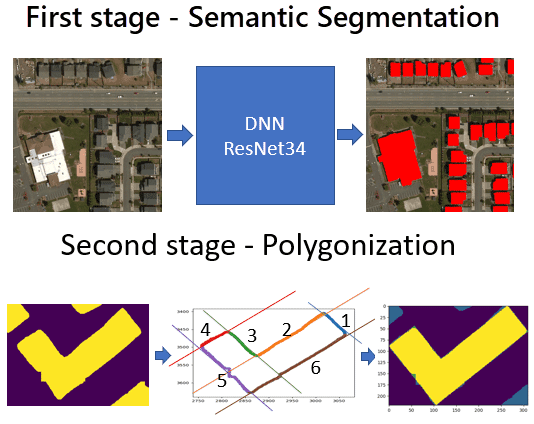
125 Million Building Footprints in the US Now Available as Open GIS Data
Microsoft has made 124,885,597 footprints from all 50 U.S. states available as open data.

Improving Geospatial Data Search
Open standards and protocols have facilitated data sharing and application for spatial information on the web such as using Web Map Service (WMS).