
Articles

How to Make a Tile Grid Map Using Google Sheets
This tutorial provides instructions on how to create a tile grid map using Google Sheets.
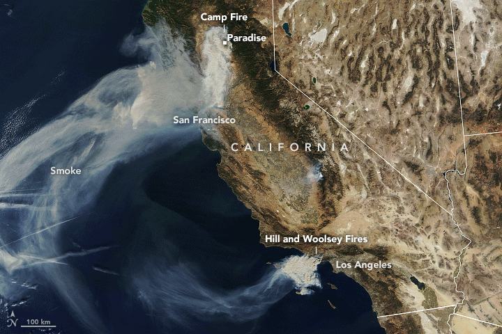
Smoke from the Camp Fire is Making Northern California Air Among the Unhealthiest in the World
The continual arrival of smoke from the Camp Fire has pushed cities in the northern California area to air pollution levels to some of the highest around the world.

Planting Trees with Drones
BioCarbon Engineering is working with Worldview International Foundation and Worldview Impact Foundation to develop an innovative way to speed up tree reforestation projects with the use of drones.

Geography of Fortune 1000 Companies in 2018
Geography of the Fortune 1000 for 2018: learn about which states and cities have the highest number of Fortune 1000 companies.
Map and List of Fortune 1000 Companies for 2018
Map and list of Fortune 1000 companies for 2018, according to Fortune Magazine.

Review | Oxford Atlas of the World, 25th Edition
The Oxford Atlas of the World, 25th edition, has a new feature on Tourism and Travel and new maps on armed conflicts around the world, as well as a new map on Antarctica using the latest data from the British Antarctic Survey.
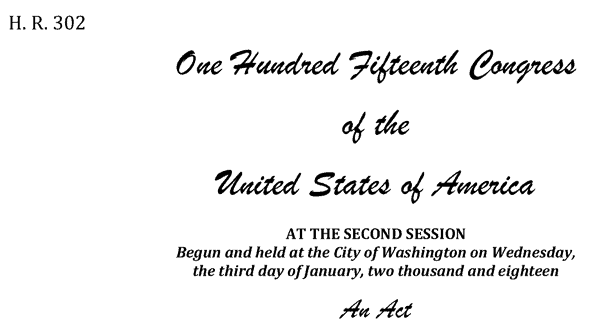
Geospatial Data Act Passes With Industry Support
The Geospatial Data Act of 2018 (GDA) was enacted on October 5, 2018, when the President signed it as a component of the Federal Aviation Administration (FAA) Reauthorization Act (H.R. 302).

QGIS Map Design, 2nd Edition
Updated to be used with QGIS 3.4, the second edition of QGIS Map Design is now available in its final version.

Geography of Fortune 1000 Companies in 2017
Explore the geographic distribution of Fortune 1000 companies for 2017.

Map and List of Fortune 1000 Companies for 2017
List of Fortune 1000 companies for 2017. This page also includes an interactive map showing the mapped location of each Fortune 1000 company in 2017.

Japanese Islet Disappears
A Japanese islet named Esanbe Hanakita Kojim made news after seemingly vanishing.

How to Change the Label Language When Using Natural Earth’s Quick Start QGIS Files
One quirk with the version 3 of the Natural Earth quick start kit .qgs file is that when you load it in to a session of QGIS, it can display labels in a language you weren't expecting.

How Does GPS Technology Affect Our Understanding of Place?
How is an over reliance on GPS technology affecting our understanding and experience of place?

Mapping the Progression of Invasive Species with Crowdsourced Data
Researchers have mapped out approximate 48,510 harlequin ladybird (Harmonia axyridis) sightings – all obtained through participation of the public – over the course of a decade.

Mapping Mediterranean UNESCO World Heritage Sea-level Rise Flood Risk
A Kiel University study has shown that some World Heritage Sites are at risk for damage in the face of changing sea level from climate change.

Review | Medieval Ireland
Medieval Ireland is Clare Downham's comprehensive synthesis of the current state-of-play of the history of medieval Ireland, 400-1500 A.D.

How to Use the Equal Earth Map Projection in Different GIS and Mapping Software Applications
Listed here are GIS and mapping resources that have incorporated the Equal Earth Map Projection.

World’s Largest Water Bridge
The world's largest sea bridge/tunnel system, which took nine years to build, connects Hong Kong to Macau and the mainland Chinese city of Zhuhai.

Using Satellite Imagery to Map Obesity Rates
One study recently looked at about 150,000 high resolution satellite images of cities in the United States along with census data of these areas in order to understand obesity rates in the built environment.

Understanding Climate Change Through Historical Shipping Logs
Geographic information and weather data recorded by ship crews are a valuable source of historical information that could be utilized to understand how our climate has changed.

How to Get the Map View in QGIS to Resize Properly on a Mac
One Mac OS specific bug is the map view canvas doesn't fill the available space in QGIS 3.x versions. Learn how to fix this.

How to Populate a Cell with the ZIP Code Based on an Address in Google Sheets
You can set up a simple function in Google Sheets to be able to populate a separate column with ZIP code dat based on address data.

Awesome Public Datasets
If you're looking for sources of public data tucked into web sites, then check out Awesome Public Datasets, Free GIS Datasets, and Open Data Inception's map of open data portals.

Analysis of U.S. Climate in August 2018
For the summer of 2018, the contiguous United States lived through its 4th warmest summer on record, tying with the summer of 1934.
The Equal Earth Map Projection
Researchers recently announced the development of the Equal Earth map projection, which has quickly gained influence due to its ability in maintaining accurate area without distortion.

How Collecting LiDAR is Being Supported by the USGS 3D Elevation Program
Quantum Spatial (QSI) is currently working on more than two dozen LiDAR collection projects in support of the 3DEP. Here’s a look at three of the projects QSI has worked on in 2018.