
Articles

Deforestation Is Drying Up Atmospheric Rivers
Deforestation has a dramatic impact on climate, reducing evapotranspiration which feed atmospheric rivers.

What Can You do with a Degree in Geography?
A good geographer should have knowledge of human-environment relationships, spatial and statistical analysis skills, proficiency in data visualization and strong communication skills.

Using GIS to Assess Crime Risk
The use of GIS and spatial analysis has become an important tool in understanding crime patterns.

Ice Circles
Ice circles are a rare occurrence in rivers, streams, and creeks worldwide.

Using Repeat Photography to Capture Landscape Change
By capturing the same view through photography, researchers can study how the landscape is changing over time.

Using Machine Learning and Surface Deformation Data to Predict Earthquakes
There is no easy solution for earthquake prediction, but machine learning in particular has made forecasting far better.

GIS and Named Entity Recognition: Identifying Geographic Locations in Text
New methods in natural language processing are being developed that are merging geographic information with basic texts and human language.
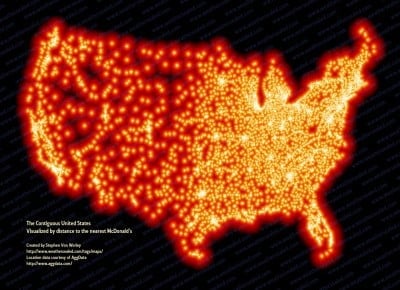
McFarthest in the Lower 48 – Map of McDonald Locations
Stephen Von Worley has mapped 13,000+ locations covering every McDonalds in the continental United States.

USGS 3DEP Lidar Point Cloud Repository Available as an Amazon Public Dataset
Representing trillions of LiDAR points, USGS 3DEP Lidar Point data is now available as an Amazon Public Dataset.

Geography Extremes
Find geography facts about the hottest, coldest, tallest, remote places on Earth.

Using GIS in Golf Course Management
GIS has a growing role in golf from managing courses to facilitating the symbiotic relationship between golf courses and environmental protection.

Automatic Raster Reclassification with ArcMap Model Builder Based on Raster Statistics
Alexandros Voukenas writes about the problem of automatic raster reclassification based on its statistics, using ArcMap’s Model Builder with this step-by-step guide with relevant screenshots and explanations

The Equal Earth Physical Map is Free
Both the physical and political Equal Earth maps are in the public domain which means users can use them however they want to.

Sunday Maptinee: Time-lapse Animation Shows How the World’s Second Largest Atlas Was Digitized
Watch this time-lapse video of the world's second largest atlas being digitized.

Review | Maps (Poetry)
This slim book reminds us that maps are not just lines and images on a surface – on paper or a globe – they are also emotional passages into the remembering and the meaning of our lives.

Ethiopia’s Church Forests Are Pockets of Biodiversity
Also known as coptic forests, church forests range in size from a few acres to 300 hectares and provide a range of spiritual and ecological benefits to the local community.

What’s the Tallest Point in Niger?
Located in northern Niger, Mont Idoukal-n-Taghes rises to a summit height of 2,022 meters (6,634 feet) above sea level.

ICESat-2: Highest Resolution Laser Altimeter
ICESat-2's purpose is to collect detailed measurements of the Earth's surface using its Advanced Topographic Laser Altimeter System (ATLAS).

This 1835 Map Shows Incredible Detail About the Longest Cave System in the World
In 1835, Cincinnati-based surveyor Edmund F. Lee created this elaborately detailed map of Mammoth Cave.

Updated World Magnetic Model To Be Released
An acceleration in the Earth's magnetic field has triggered an early update to the World Magnetic Model.

Waipā Garden in Kauai, Hawaii Now Holds the 24-Hour Precipitation Record for the United States
A rainfall gauge located at the Waipā Foundation in Kauai, Hawaii set the record for the most rainfall in a 24-hour period in the United States.
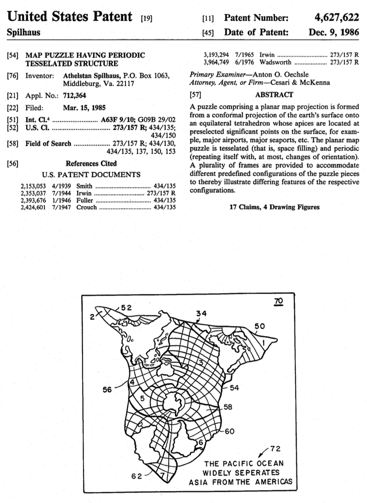
The Spilhaus Endless Ocean Map Projection
However, in 1942, a South African meteorologist, oceanographer, and inventor Athelstan Spilhaus created the world’s first fully ocean-centered map projection.
“Adopt A Pixel” to Help Landsat Science
Adopt A Pixel program has existed for quite some time - from 2013 - in the form of a web service which allowed users to upload geospatially tagged landscape images to complement the remote sensing collections.
What is Necrotecture?
Necrotecture is an urban planning coined termed by Rowland Atkinson to describe the "dead residential space" created by a high density of mostly vacant residential dwellings.

Over 600 Maps Added to South Dakota Digital Archives
The South Dakota State Historical Society has made over 600 maps available online with the South Dakota Digital Archives.

Study Discovers That This Methane Depleting Atmospheric Molecule Can Recycle Itself
The hydroxyl radical’s reactivity has earned it the nickname “air detergent” - because of the way it effectively breaks down other gasses in the atmosphere, especially methane.