
Articles

Fossil Finds Reveal More About the ‘Cambrian explosion’ – When Oceans First Developed Complex Life
Recent fossil finds in China reveal Cambrian seas were more diverse than thought.

Maps on Manhole Covers
Cities like Seattle, Chandigarh (India), and Oldenburg (Germany) have designed manhole covers with maps of their respective cities.

Topography of Australia’s Intertidal Zone Available as Open Data
The National Intertidal Digital Elevation Model (NIDEM) is the first 3D model of Australia's intertidal zone. It is available for downloading as an open source dataset from Australia's National Map portal.

Is a Vitamin Deficiency Killing Wildlife?
Researchers believed that thiamine (Vitamin B1) deficiency is playing a role in declining populations of some wildlife.

Warmer Oceans Will Make Hurricanes More Intense
Since hurricanes draw their energy from ocean heat, warmer waters can increase both their intensity and duration.

Tutorial: Introduction to Geospatial Analysis in R
Explore the "Introduction to Geospatial Analysis in R" tutorial for lessons on importing files, layer management, and making maps.

Lessons From a Viral Map
As public engagement becomes more and more important to society, it’s useful for scientists to know what makes maps and other geospatial content go viral.

Are Safaris the Best Answer for Elephant Conservation?
Tourism can be a great conservation tool as long as it is monitored closely.
The Wide Impact of Tropical Cyclone Idai
The effects of Tropical cyclone Idai were felt as far south as South Africa

How Climate Change is Affecting Tick Season
As the global climate warms, it is more likely that some ticks will remain active through the warmer winters and can expand their habitats into new areas.

Can Humans Sense Earth’s Geomagnetic Field?
A group of researchers wanted to test if humans have the ability to sense the Earth's geomagnetic field.

Children’s Book: “Lindsey the GIS Specialist”
The next time a child asks you to explain what GIS is, you might want to read them this online book about Lindsey the GIS Specialist.

Spatial Income Inequality and Climate Change
The relationship between CO2and climate change emissions in general and wealth inequality is not a clear one.
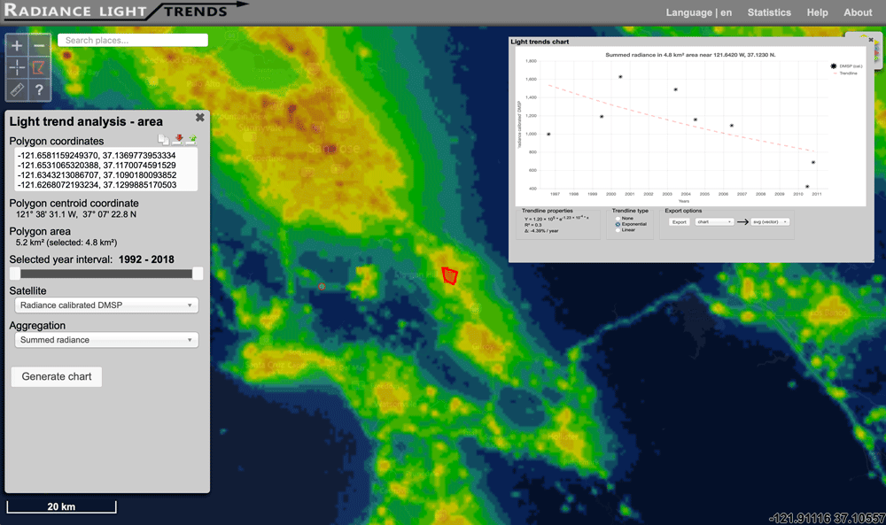
Interactive Map of How Nighttime Light Pollution Has Changed Around the World
The Radiance Light Trends website offers an interactive map where users can see how night light pollution has changed between 1992 to the present.

The Geography of Borrowing Size
Towns can 'borrow size' from nearby urban areas, enhancing their economic prospects and resilience by leveraging networks with larger towns.

Scotland: Defending the Nation, Mapping the Military Landscape | Book Review
'Scotland: Defending the Nation, Mapping the Military Landscape' is a comprehensive history of modern Scotland illustrated through such maps.

How Archaeologists Used GIS to Explore Sounds of the Past
Two archaeologists used GIS tools to model the ancient soundscape of New Mexico’s Chaco Canyon.

LandViewer Has Added New Remote Sensing and Satellite Imagery Analytics
This article by EOS, a company which creates solutions for Earth observation imagery processing and analysis, introduces a host of updated capabilities in its LandViewer tool.

The First Color Images of the Earth from Space
The first color photographs of the full-disk view of the Earth were taken in 1967

Urbanization Makes the Surrounding Atmosphere Drier
Researchers in southern China have analyzed the impact of urbanization on local climates, known as the urban dry island (UDI) effects.

Using Dark Fiber to Measure Seismic Activity
Researchers wanted to test if unlit fiber cable could be used to collect measurements of seismic activity to fill in spatial gaps in the data.
These Two Species Are No Longer Extinct
Recently, two formerly extinct species were separately discovered to still be living.
Review | There is No Planet B: A Handbook for the Make or Break Years
Mike Berners-Lee presents an ‘evidence-based practical guide to the make or break choices we face now’ in the Anthropocene age.
What Helps to Increase Public Participation in GIS?
Community participation in GIS through PPGIS is a worthy goal and has been applied in many studies for decades.

With Only Numbers and No Street Names, This Norwegian Town is Confusing Tourists
A Norwegian municipality decided to only give the chalets in a development numbers with no corresponding street names.

What are the Benefits of Landsat’s Current Free and Open Policy?
A group of researchers from different universities and government groups have published a study of how Landsat's free and open data policy has benefitted users of the programs satellite imagery products.