
Articles

Japan’s Highest Mountain
At 3,776 meters (12,389 feet) tall, Mount Fuji is Japan's highest mountain.
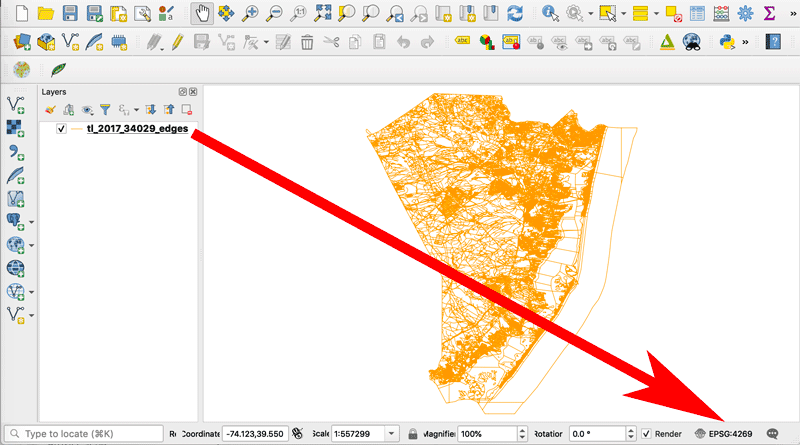
How to Change the Projection of a Shapefile Using QGIS
If you know your shapefile's beginning coordinate system or projection, you can export the data using QGIS.
With the Help of GPS Trackers, 40 Tons of Trash is Removed from the Pacific Ocean
Ocean Voyages Institute (OVI), a nonprofit, recently collected 40 tons of trash from the Pacific Gyre.

How Refugees are Using GIS to Map Their Geographies and Experiences
Story maps are a powerful tool that visualize events and what has happened to those who are displaced.

Analyzing the Benefits of Green Space on Mental Health Using GIS
A study in Denmark combined historical Landsat satellite data and a survey to analyze the relationship between green space and mental health.

NASA is Expanding its Worldwide Landslide Data Catalog Using Volunteers
NASA has developed Landslide Reporter as a way to collect as much information as possible about landslides from citizen scientists from around the world.
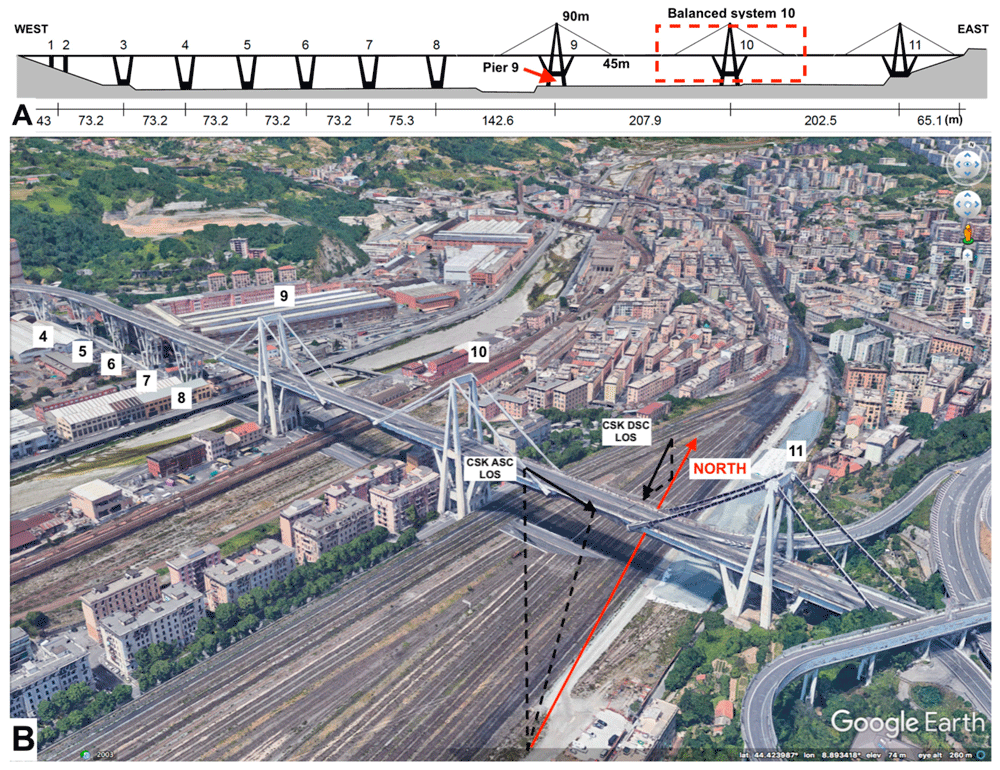
Using Remote Sensing to Detect Structural Changes in Bridges
Researchers are using synthetic aperture radar (SAR) collected from satellites to detect structural changes in bridges.

Mapping Ground Movement From the 2019 California Earthquake with Satellite Data
Researchers with NASA's Jet Propulsion Laboratory have used satellite data to map out surface displacement from the 2019 California earthquakes.

New GIS Dataset: Forest Carbon Stocks for the Western United States
Covering 11 states, this GIS dataset contains annual estimates of carbon stocks, fluxes, and productivity for Arizona, California, Colorado, Idaho, Montana, Nevada, New Mexico, Oregon, Utah, Washington, and Wyoming.

Mapping Where Planting Trees Can Help with Climate Change Mitigation
Researchers have mapped out where to plant trees to mitigate climate change.

Geography of Vulnerability: Which Communities Are Most Affected by Wildfire?
Communities that live close to areas where forest and brush fires occur, at least in the United States, have been recently demonstrated to be predominately African American, Hispanic, or Native American.

First Practice Exam for GISP Certification Released
A practice exam for the GISP certification has been release which contains 50 questions broken down in the six knowledge categories.

Changes to the National Land Cover Database
The National Land Cover Database is a GIS dataset that is seen as critical for monitoring the impact of fires, particularly increased wildfires in the West, general health of ecosystems, biodiversity monitoring, and increasing effects of climate change on land cover.

Gini Coefficient and GIS: Mapping Income Disparities
The Gini coefficient is a long-standing measure used by major organizations, such as the UN and government entities, to measure disparities between income and wealth in countries.

Urban Beehives Help Reveal Sources Of Pollution In Cities
Researchers have tested honey from six Vancouver neighborhoods from varying districts (urban, industrial, residential and agricultural) for levels of lead, copper, zinc, and other pollutants.

GIS and the US 2020 Census
The 2020 Census promises to be the most technically advanced census undertaken, where data, for the first time, will be mostly collected online.

How Redlining Communities Affects Health
New methods have also been created to measure inequality to housing and health so that they can be empirically demonstrated

Mapping Migration Based on Search Data
Researchers have create ways to map migration based on online searches of migrants as they prepare to leave their country of origin.

A Case Study on Converting a Geodatabase From ArcGIS for Use in QGIS
In this article Charles Altendorf outlines a method he developed to convert GIS data located in a geodatabase created in ArcGIS into open source data that can be used in QGIS.

Large Glacier Flour Storm Captured by Satellites
When winds in Greenland are strong enough, they can carry large plumes of glacier flour that have collected on the floor of dried out floodplains.

Review | Sprawlball: A Visual Tour of the New Era of the NBA
Sprawlball demonstrates how basketball – that is, its professional incarnation in the NBA – has become a game of analytics.

Real-time Fire Mapping and Satellite Data
New satellites and improved image processing methods are better enabling the ability to provide real-time and near real-time mapping of wildfires.

Case Study: How Brindisi, Italy is Using GIS to Help Preserve its Ancient Architecture
The city of Brindisi, Italy deployed a solution from Pitney Bowes® that provides 80 to 90 percent faster performance, while dramatically improving the user-friendliness of maps and significantly reducing staff time dedicated to mapping.

First Data from NASA’s GEDI Program to 3D Map Forests
The first set of data that have returned have demonstrated GEDI is able to measure density of forests far better than previous satellite missions.

2018 NAIP Imagery
Aerial imagery covering 20 states has been added to the USDA's direct access site for NAIP imagery.

Free Synthetic Aperture Radar Handbook Available
This free handboo provides insight into how different Synthetic Aperture Radar (SAR) methodologies can be used for forest monitoring and biomass estimation.