
Articles

Platforms for Making Deep Learning Easier for GIS
New tools have been developed to facilitate the integration of deep learning tools within GIS applications.

Maps that put a Twist on Global Population
Cartographers have created maps that showcase the diversity of the world’s population in unique ways.

What’s on the Other Side of the World?
The spot diametrically opposed to a location on Earth is called the antipode.

These Two Satellite Images Highlight the Disappearance of a Glacier
Okjökull was once a large glacier in Iceland located in western Iceland on top of the volcanic mountain Ok.

New Map Shows How Fast Ice is Leaving Antarctica
Researchers used synthetic-aperture radar (SAR) data to look at how the ice is moving and shifting on Antarctica.

Voronoi Diagrams and GIS
Voronoi diagrams can be created by many GIS packages today for understanding spatial patterns.

New Findings on How Trees Impact Droughts
Recently published research looked at the question of, "Instead of looking at how drought affects the forest, how might this go the other way around?"

How Hydropower is Changing the Balkan Landscape
How is the proliferation of hydro power plants (HPPs) changing Balkan peninsula's landscapes?

Mapping the Human Footprint
The world settlement footprint, created in a online application called Urban Thematic Exploration Platform (TEP) sponsored by the European Space Agency (ESA), is the first map that combines optical and radar satellites to create a human urban footprint map of the world.

Increasing Tree Cover Linked to Improved Community Mental Health
Studies show that adults who live in a neighborhood that has 30% or more tree coverage have lower odds of experiencing psychological distress in their lifetime.
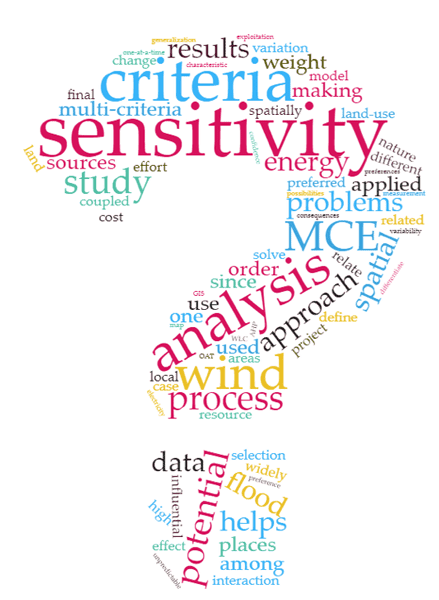
Determining Uncertainty in GIS Data
Multi-Criteria Evaluation (MCE) has widely been coupled with GIS to solve the spatial decision-making problems where there are several measures to be compared and screened for decision alternatives.

Version 3 of the ASTER Global Digital Elevation Model Released
2.3 million scenes from the ASTER archive were processed to create the latest version of the ASTER Global Digital Elevation Model (GDEM).

Using Crowdsourcing and Deep Learning to Map Human Settlements
Machine learning techniques are being used to map new urban and land use patterns that were previously difficult to detect using crowdsourcing data.

3 Ways Geospatial Data is Changing the Way We Manage the Environment Around Us
Dr. Michael Flaxman, director of Geodesign Technologies and Geospatial Community Advocate for OmniSci, presents three example of how newly available geospatial data is being leveraged.

What Skills Does a Geographer Need?
To be a successful geographer, certain skills are needed in order to be able to understand the Earth’s physical environment as well as human patterns and processes.

Greenland’s Ice Arch Crumbles Earlier Than Normal
Across the Nares Strait, between Greenland and Ellesmere Island, lies a horizontal ice arch.

How Google Earth Engine Has Changed Access to Remote Sensing Data
Google Earth Engine provides access to remote sensing data without requiring advanced software or skilled geospatial technicians.
Uber’s Open Source Mapping Tool
In 2016, kepler.gl, Uber’s mapping tool used to track and map journeys on its popular ride hailing application, was released as an open source project by the company.

Working with GIS Data using Python
Explore how Python, a scripting and programming language, enhances problem-solving across spatial sciences, from GIS data handling to visualization.

GPS Tracking Shows That Black Bears Avoid Humans During the Day
A recent study found that American black bears tend to become more nocturnal during spring in summer to avoid interacting with humans as they search for food.

Tracking Lost Dogs with Their Nose Prints
A new Chinese Artificial Intelligence startup called Magvii is working on new technology that could help reunite lost pets and their owners.
Using Historical Photographs to Map Landscape Change
Researchers used historical photographs, some dating back to the mid-19th century, to analyze changes in landscapes.

The U.S. is Losing 36 Million Trees Per Year
A study from the US Forest Service has found that, nationally, tree cover is declining at a rate of 175,000 acres per year which is the equivalent of about 36 million trees lost each year.

Gulf of Mexico Remains the Second-largest Low-Oxygen Dead Zone on Earth
A newly released forecast by the National Oceanic and Atmospheric Administration (NOAA) has predicted that the Gulf of Mexico will again become the second-largest low-oxygen dead zone on after (after the Baltic Sea).
European Global Position System Failure Points to the Importance of Location Technology
What is being called a “major outage” by the European Global Navigation Satellite System (GNSS) Agency, or GSA, highlights the critical importance played by the satellite systems that provide accurate positioning and time information to devices such as mobile phones, car navigation systems and other services such as land surveying.

The Northernmost Permanently Inhabited Spot on Earth
Located 817 kilometers (508 mi) from the North Pole, Alert (82°30'05" ) is the northernmost place with a permanent (year-round) population.