
Articles
Researchers Estimate Triples the Number of People Affected by Sea Level Rise
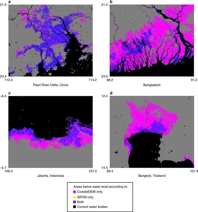
New estimates from Climate Central estimate that 340 million to 480 million people would be affected by flooding in coastal areas due to sea level rise.

What is the Difference Between an Earthquake Swarm and Aftershocks
Learn about the difference between an earthquake swarm and an aftershock.

Mapping Out California’s Methane Emissions
With half of the methane emissions originating from human activities, researchers from NASA wanted to map out point-source emitters in California to understand where the highest volume of methane emissions occur.

PennVet Uses GIS to Identify Disease Hot Spots
Dr. Meghann Pierdon with the University of Pennsylvania’s School of Veterinary Medicine has developed a secure website that uses GIS to map out the incident of diseases among pigs or birds.

Largest Expanse of Sand in Ukraine
Located in southern Ukraine is the largest sand area in the country.
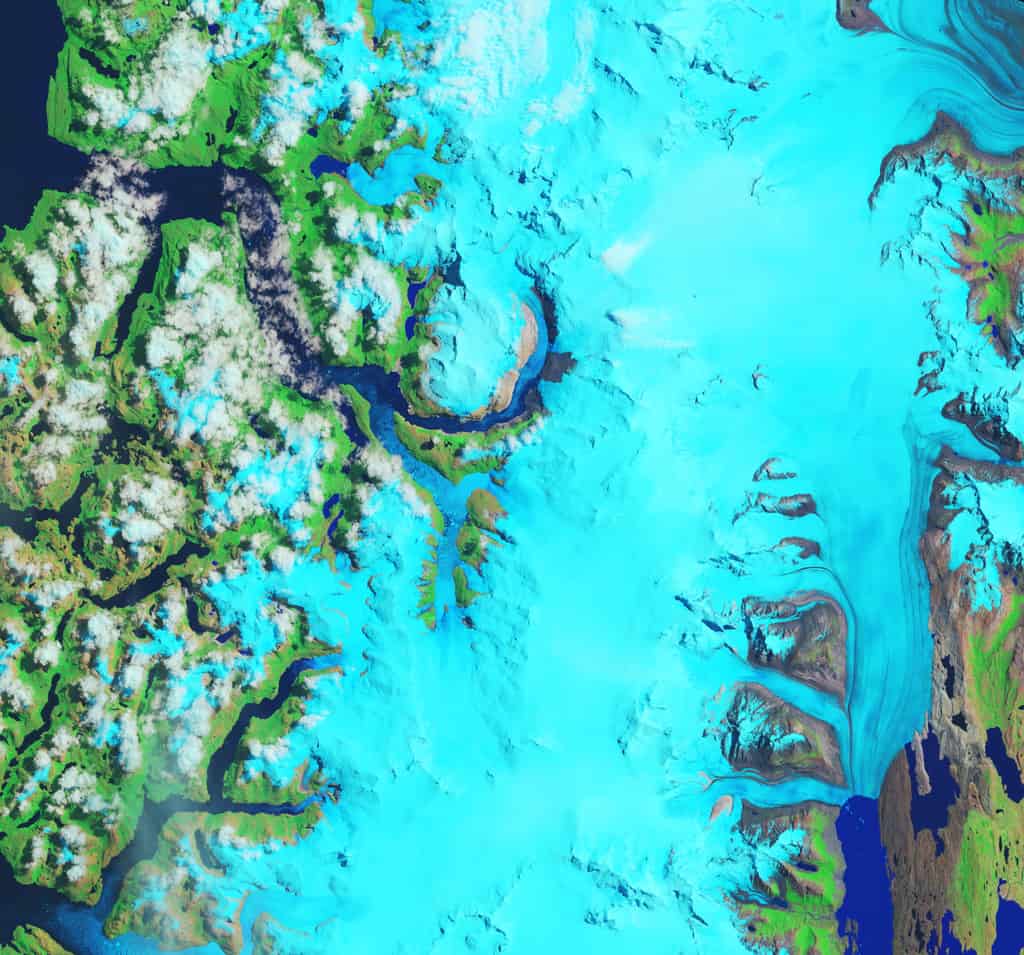
Fastest Thinning Glacier
Hielo Patagónico Sur 12 (HPS-12) in Patagonia is believed to be the fastest thinning glacier in the world.

New Report Values Economic Benefits of Landsat Archive at $3.45 billion
A newly released report from the USGS has estimated the 2017 domestic and international economic benefits of Landsat imagery to be $3.45 billion.

Using GPS to Improve the Accuracy of Drone Mapping
By improving the precision of the GPS devices on UAVs, it is now possible to create much more accurate maps without needing to physically visit the area in order to ground truth.

Earliest Published Research Linking Carbon Dioxide with Global Warming
163 years ago, Eunice Newton Foote was the first scientist to research the link between increased carbon dioxide and a warmer atmosphere.

How Goats in Samothraki are Increasing Landslides
Overgrazing by the island's large goat population has left Samothraki’s hills and valleys unprotected by vegetation, making them vulnerable to landslides and erosion from heavy rainfall and other weather.

How to Use GIS to Make a Lego Map
Depending on the GIS software you want to use, there are a few different ways to create a Lego-style map.

Mapping the World’s Islands
A new USGS and Esri project has mapped 340,691 of Earth's islands, creating a publicly available GIS dataset.

First High Resolution Map of the U.S. Food Supply Chain
A team of researchers used data from several federal sources and the Oak Ridge National Laboratory to produce the first high resolution map of how food moves around the United States.

Portable GIS
Portable GIS is a collection of open source GIS software applications and tools that can be run from a portable drive.

Malvinas Current
The Malvinas Current is a cold water current that flows northward along Patagonia's Atlantic coast.

Researchers Find Thriving Bee Populations in Power Line Corridors
Researchers have found that the bee populations located in the power line corridors were nearly ten times as high as the bee populations living in the more forested areas nearby.

How Much Carbon Dioxide are the Oceans Absorbing?
New research shows that the world's oceans, which cover 70% of the planet, absorb more carbon dioxide than previously thought.
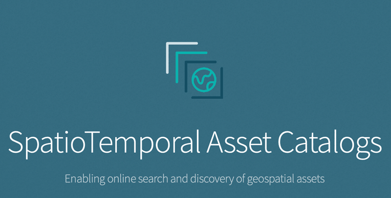
Making Finding Geographic Information Easier: SpatioTemporal Assets Catalogs
SpatioTemporal Assets Catalogs (STAC) provides a common set of search terms so that geospatial information can be found and indexed easily.

This Lake is Home to the Highest Concentrations of Lesser Flamingos in East Africa
The protective salt marshes that ring Lake Natron in Tanzania have nurtured the highest concentrations of lesser and greater flamingos in East Africa.

Online Landslide Inventory Mapping Tool
The USGS has launched an online web map that compiles existing United States landslide data into a searchable tool called the U.S. Landslide Inventory Map.

Mule Deer Create Mental Maps Of Migration Routes
During their seasonal migrations, large grazing mammals like deer are able to easily navigate the state of Wyoming.

Structurally Complex Forests Better At Carbon Capture, Study Shows
Researchers have discovered that structurally diverse forests are better at carbon sequestration that monocultures.

Geospatial Data and Sustainable Development Goals
The new initiative, called Data for Now, will see the linkage of Google Earth satellite data and other GIS data with UN data.

More Frequent and Intense Tropical Storms Can Change the Geography and Ecology of Coastlines
UNC researchers studied North Carolina tropical cyclones over 120 years.

An Iceberg the Size of Greater London Has Broken Off Amery Ice Shelf in Antarctica
An iceberg the size of Greater London recently broke off the from Amery Ice Shelf in Antarctica.

Using Satellites to Map Air Pollution from Wildfires
The Copernicus Sentinel-5P mission is designed to monitor pollutants entering the atmosphere because of major forest fires.