
Articles

GeoQuiz: Pioneering Geographers
Take this quiz to test how well you know about the contributions of these geographers.

Spring Bird Migration is Happening Earlier for Some Birds
With changes in temperature due to climate change, researchers looking at 24 years of radar data from the National Oceanic and Atmospheric Administration (NOAA) have found that migrating birds were more likely to arrive at certain stops earlier than they would have twenty years ago.

Plant Life is Expanding in the Area around Mount Everest
Using satellite imagery, researchers have found that subnival vegetation, the vegetation that grows between the treeline and snowline, is increasing in spatial extent around the Mount Everest and Himalaya area.

Satellite Imagery Shows Fire Damage to Australia’s Kangaroo Island
Like parts of mainland Australia, Kangaroo Island has been devastated by bushfires fueled by drought and intense temperatures.

Physical Geography Facts About Iran
Iran, known officially as the Islamic Republic of Iran, is a country located in the Middle East.
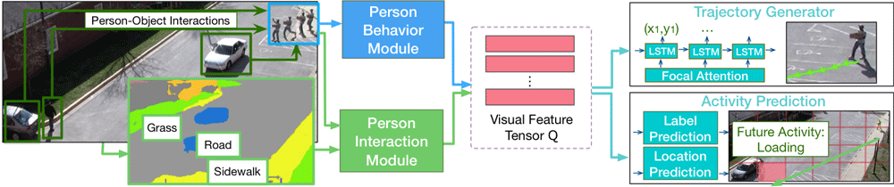
Predicting Future Movements of Pedestrians and Autonomous Vehicles
As driverless cars and motion detection technologies are increasingly integrated into our everyday lives, applications are now being developed to help with predicting movements undertaken by both pedestrians and vehicles.

The World’s Highest Concentration of Hoodoos
Hoodoos are tall, thin rock spires that occur all around the world.

Seven Summits: The Tallest Mountain on Each Continent
Listed here are the tallest mountains based on summit elevation for each of the seven continents.

What is Snapping in GIS?
Snapping involves connecting a geometric vertex or edges of one feature to another when editing a GIS dataset.


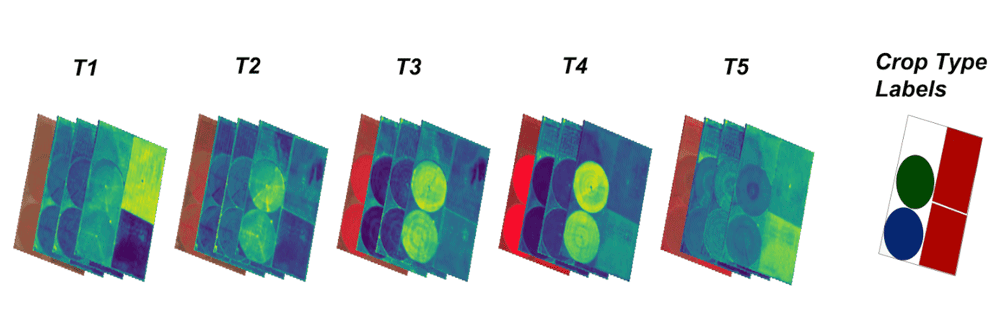
Monitoring Crop Production Via Satellite
To cope with ever-changing agricultural needs and conditions, the USDA’s National Agricultural Statistics Service (or NASS) uses data from Landsat to monitor crops in the contiguous United States.

Null Island: Where Geocoding Errors Go to Live
Null Island, a fictional location at the confluence of the Equator and the Prime Meridian, is used for troubleshooting purposes as a way to flag geocoding failures.

Connecting Fragmented Habitat Improves Biodiversity
Researchers found that connecting natural corridors of habitat to one another promotes biodiversity in the plants and animals that are able to thrive in those locations.

Biodiversity and Climate Change Adaptation
Many cities globally are forging ahead with climate change adaptation.

Life at the Entrance to the Arctic Ocean
Researchers traveled to the Chukchi Borderlands to learn more about deep ocean life at the entrance to the Arctic Ocean.

The Greenland Ice Sheet Has Lost 3.8 Trillion Tons of Ice
A new report analyzed 26 satellite datasets to track ice loss for the Greenland Ice Sheet.

Automated Remote Sensing of Underground Features
Below ground mapping can now better utilize remotely sensed data to create more accurate maps.
Open Repository for Geospatial Training Data Released
Radiant Earth has launched Radiant MLHub, a cloud-based open library for training geospatial data used by machine learning algorithms.

Sunny Day Flooding is Increasing
Research has shown that the instances of tidal flooding have increased on the Atlantic, Pacific, and Gulf coasts of the United States.

Review | The Citizen’s Guide to Climate Success
This is a most useful primer on climate change and its consequences.

Satellite Data Shows That Tilling Less Leads to Healthier Soils
Researchers applied machine learning to satellite-derived datasets to to analyze tillage practices and crop yields in the US Corn Belt between 2005 and 2017.

There are Four Trillion Measurements in this Global Sea Surface Temperature Dataset
Researchers have compiled an enormous global dataset with over four trillion satellite-based measurements of sea surface temperature.

Do Bison Influence the Spring Season?
Researchers took a look at the foraging behavior of Yellowstone’s bison (Bison bison) to see how well their grazing behavior fits with the Green Wave Hypothesis.
MERIT Hydro: A High-Resolution Global Hydrography GIS Dataset
Researchers have developed a high-resolution GIS dataset of river systems using remotely sensed data and OpenStreetMap data.

EarthPy: Python Package for Plotting and Working with Spatial Data
A Python language spatial package, called EarthPy, has been released for free download for working with GIS data.

How Wildfires are Changing Boreal Forests and Increasing Emissions
Boreal forests are changing along with our climate.