
Articles

Open Access Novel Coronavirus Data
A newly published article in Nature's Sci Data decribes how epidemiologists collected and curated individual-level novel coronavirus data from a variety of national, local, and news sources.

See the First Atlas Created of a Country
The "Atlas of the Counties of England and Wales," published in 1579, is the first atlas produced for any country.
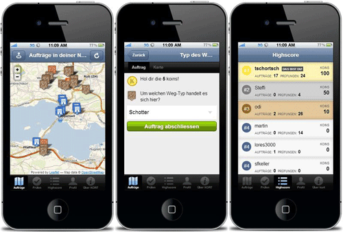
How to Volunteer Your GIS and Cartography Skills
Those with GIS and cartography skills that want to volunteer to help out can do so remotely with these calls for actions as mapping non-profits respond to the coronavirus pandemic.

Giant Sequoia Forest Earns Protected Status
A privately owned forest comprised of giant sequoia trees has recently earned protected status, thanks to a long-term effort by California’s Save the Redwoods League.

GIS and Cartography Material Available for Online Teaching
Several institutions and professors have offered up readily available online resources that can be used to virtual teach cartography and GIS courses.
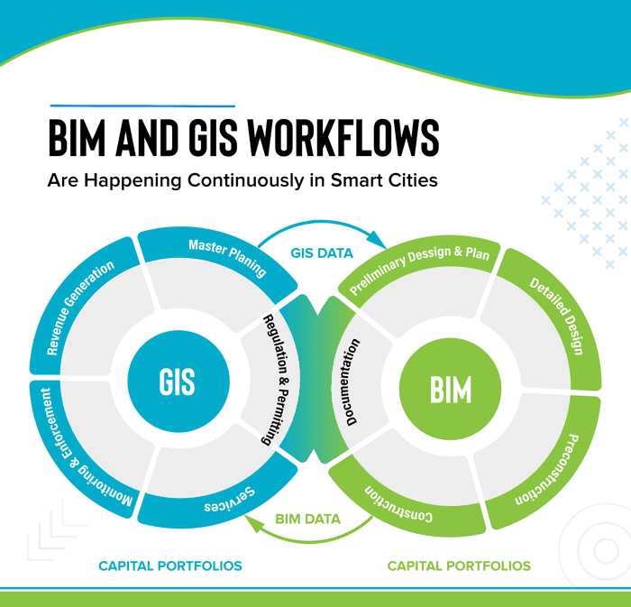
GIS and BIM Integration in Infrastructure Design and Construction
The latest advancements in geospatial services are making changes in the AEC industry. BIM for infrastructure design helps improve the workflow and saves valuable data through every stage of the process. Read about how GIS and BIM integration will transform these industries.

Geography of Quarantines
Geographic research can be used to assess the effectiveness of past quarantines in controlling viral diseases.

Higher Carbon Dioxide Makes Grasslands Less Nutritious for Grasshoppers
One group of researchers looked at more than 40 species of grasshopper in the Konza Prairie in Kansas to see the effect of changing plant nutrients on insect populations.

Fire and Drought in the Amazon is Decimating Dung Beetle Populations
Fire and drought are killing off dung beetles in the Amazon.

Access Open GIS Data for Almost 11 Million Trees with OpenTrees
Developed by Steve Bennett, OpenTrees.org lets you visualize and download GIS data for almost 11 million city and park trees around the world.

Australia’s Yarrabubba is the Oldest Impact Crater on Earth
Recently published research indicates that the Yarrabubba impact structure in Australia may be the world's oldest.
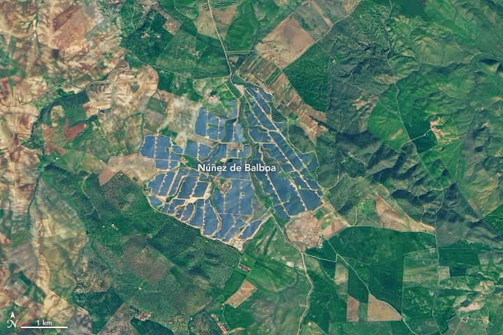
Europe’s Largest Solar Energy Plant
With 1,430,000 solar panels, Núñez de Balboa in Spain is currently Europe's largest solar plant.

Oceans Are Warming 40 Percent Faster Than Previously Estimated
A review of available studies, published in Science in January 2019, has revealed that the rate of ocean warming is as much as 40% faster than that suggested by IPCC.

Updated Global Elevation Data Released by NASA
A new global digital elevation model (DEM) has been released by NASA.

Geography of Beliefs
Geographic factors can shape our beliefs not only in our early life and development years, but they can also affect us as we move and change where we reside throughout our lives
Geotargeting by Advertisers and Government Agencies
Geotargeting by advertisers, which is the practice of sending advertisement based on location, has gained increased importance for companies marketing their product in recent years.

Mapping the Entire Surface of the Earth with LiDAR
A project called the Earth Archive plans to use Light Detection And Ranging (LiDAR) to map the entire surface of the Earth.

Geography of the Himalayas
Learn about the Himalayas, the tallest mountain range in the world. The Himalayas' peaks include Mount Everest, the world's highest.

Glaciers
Learn about glaciers including the types of glaciers and how glaciers move.

How GIS is Used in All Phases of Emergency Management
In this guest article, Brian Sekita discusses how GIS is vital to all phases of the emergency management process.

Mapping the Universe
New satellite technology achieved in in the last decade are helping scientists to more accurately map the universe.

Using GIS to Map and Track Vandalism
GIS is being used to better understand current and potentially future patterns of vandalism.

This Detailed Map Shows 119 Years of Earthquakes
The USGS has released a highly detailed and updated map of seismicity from 1900 to 2018.


Using Remote Sensing to Understand Steve in the Sky
Scientists took a scene from the movie and applied it to real life. When they observed something in the sky they didn’t understand and couldn’t readily identify, they called it Steve.

Counter Mapping and Cultural Preservation
A group of A:shiwi elders and artists are working to change how maps are drawn of their ancestral lands.