
Articles

UCLA Researchers Map the Biodiversity of Los Angeles County
UCLA researchers have mapped the biodiversity of Los Angeles County.

Niue Designated the First Dark Sky Nation
The Pacific island nation of Niue has made history as the first designated dark sky nation on Earth.

Study Shows Loss of Forest Linked to Spread of Disease
A study out of the Stanford Woods Institute for the Environment has shed new light on the many impacts to humans and wildlife that come through the practice of deforestation.

Mapping the Amount of Snow on Arctic Sea Ice
Scientists are using satellite data to measure and map the amount of snow on Arctic sea ice.

Help Map the World’s Coral Reefs
NASA has invited video game enthusiasts and people with a scientific bent to help them map the world’s coral reefs.
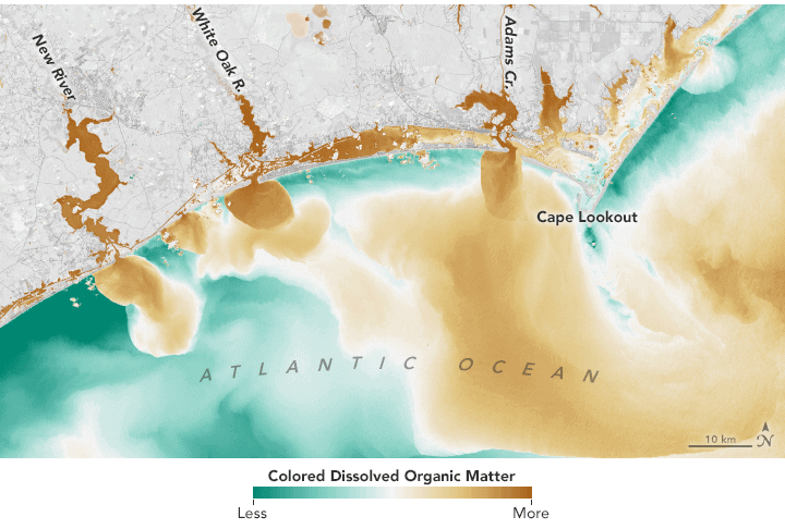
Monitoring Lakes Using Remote Sensing Data
Satellite-based remote sensing is proving to be a useful tool to allow effective monitoring of lakes around the world.

The Importance of GIS
David Falk writes about how GIS plays an important role in his career as an Army Officer, in his field as an engineer, and in his civilian life as potential homeowner and resident.

Review: Maps for Time Travelers
A survey of the geospatial technological advances which have enabled today’s archaeologists to map the ancient world.

Which Countries Have No Airport?
How many countries in the world have no airports? There are five countries, all located in Europe, out of the 196 countries in the world that have no airports located within their borders.
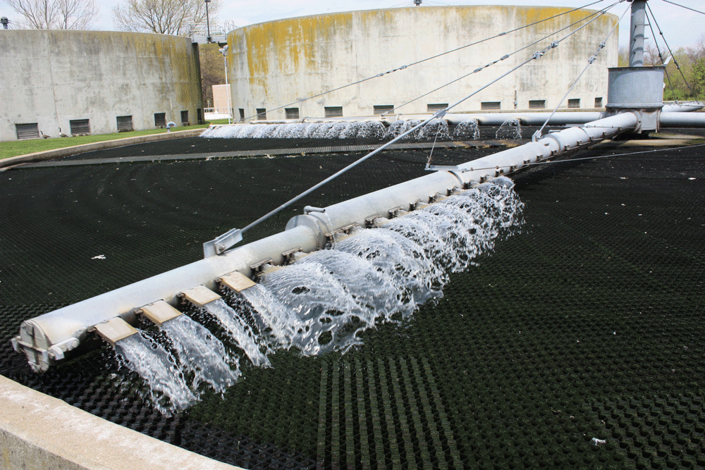
Tracking COVID-19 Through Sewage, Air, and Thermal Cameras
Given the limitations of testing, companies and researchers are using different proxies to better understand the extent of COVID-19.

Amphan is the Strongest Super Cyclone Ever Recorded in the Bay of Bengal
Amphan is a powerful cyclone that has formed in the Bay on Bengal.

Arthur is the First Named Storm of the 2020 Hurricane Season
Arthur is the first named storm of the 2020 hurricane season which officially begins on June 1, 2020.

Using Mobile Phone Data to Limit the Spread of COVID-19
Mobile phone data could be used to limit the spread of the virus while medical experts can also use it to project next steps in fighting a pandemic.

Defining the Role of GIS and Needed Skills
A recently published open access journal article presents three case studies to help analyze the level of GIS expertise needed for interdisciplinary studies.

A View of Hokkaido’s Lattice Windbreaks From Space
The landscape of the Konsen Plateau viewed from above looks like a lattice with crisscrossing lines of narrow strips of forest.

What is “Horror Vacui” in Cartography?
If you've ever looked at a map created in the 1500s and 1600s, you might notice that many cartographers have filled every space with some kind of detail.

Poplar Fluff is Highly Flammable
This video captured from a burn in Parque del Cidacos de Calahorra in Spain, shows the speed at which poplar fluff is burned.

Using Geospatial Technologies to Map Locust Swarms
Using a combination of satellite and UAV monitoring, the impact of locusts can be minimized by anticipating where swarms are likely to form next.

Building a Model with ArcGIS ModelBuilder Saves Time
Emmanuel Jolaiya shows users how to use ArcGIS ModelBuilder to develop a model for for analyzing and manipulating GIS Data.

An Introduction to ArcGIS ModelBuilder
In this overview, Emmanuel Jolaiya introduces readers to ModelBuilder in ArcGIS which can be used to build models for analyzing and manipulating GIS Data.

Lowest Latitude Sea Ice South of the Arctic
One of the lowest latitudes in the Northern Hemisphere where sea ice forms in the Northern Hemisphere is the Sea of Okhotsk.

Satellite Mapping of Oceans and Coral Reefs
In 2018, NASA launched the ICESat-2 satellite to monitor levels of ice. Researchers have found that this satellite can also measure coral reef systems.

There are Three Billion Fewer Birds in North America Than 50 Years Ago
Scientists have noticed a steep decrease in both rare and common bird species tha are found in North America.

Using Geospatial Technologies to Map and Track Food Supply Chains
Geospatial and Big Data firms such as Orbital Insight are using and combining satellite data, cellphone geolocation data, and UAV data to track food supply chains.

Atmospheric Ozone Hole Over Arctic Region
A combination of atmospheric factors have led to the creation of the lowest levels of ozone in a decade over the Arctic.

Mapping the Spread of the Novel Coronavirus: COVID-19
Johns Hopkins University (JHU) is mapping the spread of the coronavirus in near-realtime.