
Articles

Hot Cities Getting Hotter in the US
Climate Central has published a new report that took at look at the increases in temperature in sixty of the largest U.S. cities.

Urban Heat Islands
Urban heat islands are places in the world that have higher temperatures than the locations around them. These urban heat ...

Binning in GIS
Binning in GIS helps group data into categories, making it easier to see patterns and densities on maps.

Travel through Time with New York City’s Maps
The New York City Public Library introduces an online map warping tool, offering access to over 10,000 historical maps of the city.

Borders that are Visible on Satellite Imagery
Here are international borders that are visible on satellite imagery.

Geography of Fortune 1000 Companies in 2014
The 2014 listing of Fortune 1000 companies were mapped out in order to understand the answers to such questions as which states have the most Fortune 1000 companies and where are there geographic clusters of Fortune 1000 companies.
Fortune 1000 and Fortune 500 Companies by State for 2014
This table shows the total number of Fortune 1000 and Fortune 500 companies by U.S. state and territory (Puerto Rico). The list can be sorted by state, number of Fortune 1000 companies, and number of Fortune 500 companies.
List of Fortune 1000 Companies by Urban Area for 2014
A list of the total number of Fortune 1000 by urban area as defined by the US Census Bureau. The list can be sorted by urban name, total number of Fortune 1000 companies, and by 2010 population.
Fortune 1000 Companies List for 2014
Excerpt of Fortune 1000 companies for 2014 which can be filtered by state.

What is a Map?
A map is something we’ve all likely held in our hands, scratched our heads over or marked with pushpins to ...

What is the Difference Between a Heat Map and a Hot Spot Map?
Learn about the difference between Heat Maps and Hot Spot Maps in GIS.

EarthCube Data Initiative
Improvements in technology have led to the wide dissemination of information. As long as you have a computer, tablet, or ...

Using Unmanned Aircraft to Help Map Threatened Plant Species
Geography researchers at Central Michigan University have tested out the usability of UAVs in mapping out threatened plant species.

Ten Things to Know About the World’s Population
Here are 10 of the most interesting facts about the world population from the past, present, and what they can mean for the future.

Legal Geography Explained
Legal Geography is a subset of geography that takes into consideration the connections between the law and legal system and ...
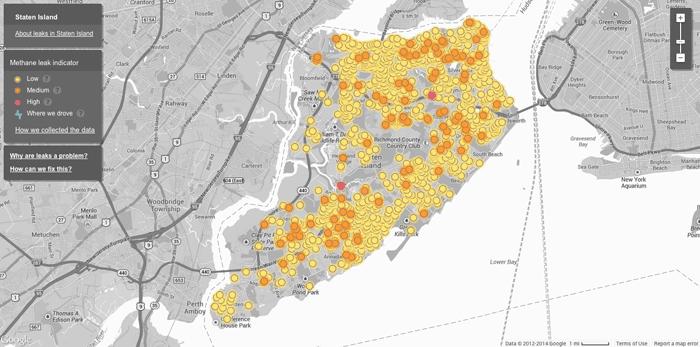
Mapping Methane Leaks with Google Street View Cars
Google partnered with the Environmental Defense Fund on a pilot project to use Google’s fleet of Street View cars to ...

No Drones Zones: Map and GIS Data
Unmanned aircraft, known more commonly as drones, have a blanket ban by the Federal Aviation Authority in the United States over military ...

Carless Cities
Cities are seeing growing problems with smog and the resulting health effects, noise pollutions, and motor vehicle related fatalities. A few cities have already put restrictions on the number of automobile in an effort to build a carless city.

Using Remote Sensing to Measure the Effect of Drought on Ground Water
This map shows a comparison of modeled relative amount of water stored in underground aquifers in the continental United States for July 7, 2014 as compared to the average for comparable weeks for the sixty year average water storage.


Geography of Industry in the US
Mapping the geographical distribution of industries in the US can provide valuable insights into the economy, opportunities for growth, and potential investment areas for scientists, economists, and the general public.
Evaluating Ecosystems from Space
The ESA has launched their Space for Ecosystem project in order to more accurately evaluate the benefits of a natural resource.
History of Geography as a Timeline
Listed here are significant events that happened in the field of Geography.

Views From the 2014 Esri International User Conference: GIS In Imagery
Photographer Kristina Jacob shares moments she captured from the 2014 Esri International User Conference that was held in July in San Diego, California.

Mapping Soil Moisture from Space
Soil moisture might not be considered a critical factor to the health of our planet but a series of satellite ...

Maps of Israel
Printable maps of Israel. This collection of maps showing the country of Israel include a detailed map showing major cities ...